
Revillagigedo Islands facts for kids
|
Native name:
Islas Revillagigedo
|
|
|---|---|
 |
|
| Geography | |
| Location | Pacific Ocean |
| Coordinates | 18°50′N 112°50′W / 18.833°N 112.833°W |
| Total islands | 4 |
| Area | 157.81 km2 (60.93 sq mi) |
| Highest elevation | 1,130 m (3,710 ft) |
| Highest point | Cerro Evermann |
| State | Colima |
| Demographics | |
| Population | 54 |
| Additional information | |
| Time zone |
|
| Official name: Archipiélago de Revillagigedo | |
| Type: | Natural |
| Criteria: | vii, ix, x |
| Designated: | 2016 (40th session) |
| Reference #: | 1510 |
| Region: | Latin America and the Caribbean |
| Official name: Reserva de la Biosfera Archipiélago de Revillagigedo | |
| Designated: | 2 February 2004 |
| Reference #: | 1357 |
The Revillagigedo Islands are a group of four volcanic islands in the Pacific Ocean. They are famous for their amazing and unique plants and animals. These islands are about 458 kilometers (285 miles) from Socorro Island and southwest of Cabo San Lucas. They are also about 698 to 1092 kilometers (434 to 679 miles) west of Manzanillo.
Even though they are far out in the ocean, the islands belong to Mexico. They were given to the Mexican state of Colima in 1861. Today, they are under the direct control of the Mexican federal government.
In July 2016, the Revillagigedo Islands became a UNESCO World Heritage Site. This means they are very important to the world's natural history. In November 2017, they were made a huge marine reserve and a national park. Some of the volcanoes on the islands are still active. The last eruptions were in 1953 and 1993. It takes about 26 to 30 hours to reach the islands by boat. There is a small military airstrip on Socorro Island.
Contents
Geography of the Revillagigedo Islands

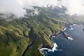
The Revillagigedo Islands cover a total area of about 157.81 square kilometers (60.93 square miles). They stretch out over 420 kilometers (261 miles) from east to west.
There are only a few people living on the islands. A naval station on Socorro Island has about 45 staff members. On Clarión, there is a small naval base with nine men. The rest of the islands are not inhabited. The islands are named after Don Juan Vicente de Güemes, 2nd Count of Revillagigedo. He was a viceroy of New Spain a long time ago.
Island Details and Time Zones
The Revillagigedo Islands are made up of four main islands:
- San Benedicto: This island is about 4.3 kilometers long and 2.5 kilometers wide. It covers 5.94 square kilometers. Its highest point is Bárcena, which is 310 meters high.
- Socorro: Also known as San Tomás, this is the largest island. It is about 16.8 kilometers long and 15.6 kilometers wide. It covers 132.06 square kilometers. Its highest point is Mount (Cerro) Evermann, at 1130 meters.
- Roca Partida: This is a very small island, only 0.246 kilometers long and 0.073 kilometers wide. It covers just 0.014 square kilometers and is 34 meters high.
- Clarión: Also called Santa Rosa, this island is about 8.5 kilometers long and 3.7 kilometers wide. It covers 19.80 square kilometers. Its highest point is Monte Gallegos, at 335 meters.
The three eastern islands (San Benedicto, Socorro, and Roca Partida) are in the Mountain Time Zone (UTC-7). Clarión Island is much farther west, over 200 kilometers away from the other islands. It is in the Pacific Time Zone (UTC-8). These islands are unique because they are not on the continental shelf, unlike most islands close to a mainland.
History of the Islands

No one lived on these islands before they were found by Spanish explorers.
Early Discoveries (1500s-1800s)
- In 1533, Hernando de Grijalva and his crew found an uninhabited island on December 19. They named it Santo Tomás (now Socorro Island). On December 28, they found Isla de los Inocentes (now San Benedicto Island).
- In 1542, Ruy López de Villalobos rediscovered these islands. He was the first to see and name Roca Partida.
- In 1608, Martín Yánez de Armida visited Anublada (Socorro) and renamed it Socorro.
- In 1779, José Camacho was the first to report seeing the last island, which he called Santa Rosa. This island was later renamed Clarion.
Many other explorers visited the islands over the years. On July 25, 1861, Mexican President Benito Juárez signed a law. This law gave control of the four islands to the state of Colima. He wanted to build a prison on Socorro Island, but it never happened. However, the law connecting them to Colima has never been changed. In 1865, a scientist named Andrew Jackson Grayson explored the islands. He discovered several unique birds, like the Socorro dove and the Socorro mockingbird.
Twentieth Century Events

In the early 1900s, Dr. Barton Warren Evermann helped organize scientific trips to the islands. Many important collections of plants and animals were made then. The volcano on Socorro Island was named after him.
In 1957, the Mexican Navy built a base on Socorro Island. They have had people living there ever since. There is also a small outpost on Clarión. In 1972, the Governor of Colima visited the islands to show that they belonged to his state.
The waters around the islands are popular for scuba diving. Divers can see amazing marine life like cetaceans (whales and dolphins), sharks, and manta rays. Visitors usually stay on boats to protect the islands' environment. It is hard to land on the islands, so it can be dangerous to visit them for anything other than diving.
Sometimes, amateur radio operators visit the islands. Scientists also visit regularly to study and protect the unique wildlife. There are no hotels or tourist facilities on the islands. They also don't have their own reliable source of fresh water.
Twenty-first Century Protections
On November 24, 2017, President of Mexico Enrique Peña Nieto created North America's largest marine protected area around the Revillagigedo Islands. This huge protected area covers about 147,600 square kilometers (57,000 square miles) around the islands. It bans fishing, mining, and tourism development in the area and on the islands. This protection helps the ocean's diversity and fights climate change. A study found that fishing in the protected zone dropped by 82% after it was created.
Ecology and Wildlife
The Revillagigedo Islands are home to many plants and animals found nowhere else in the world. Because of this, they are sometimes called Mexico's "little Hawaii". They are recognized as a special terrestrial ecoregion. Socorro Island has the most different types of plants, animals, and landscapes. The Mexican Government made the islands a Biosphere Reserve in 1994. Experts say it's one of the most diverse and exciting marine places on Earth.

The islands are mostly covered with tropical dry forests. Different plant groups grow depending on the elevation, soil, and how much sun they get. Some common trees are hopbush and Guettarda insularis. Along the coast, you can find green buttonwood mangrove and Hibiscus tiliaceus.
Unique Birds of the Islands
The islands are very important for birds. Many of the 16 types of landbirds that live here are found only on these islands. These include:
- Clarión wren
- Socorro wren
- Socorro mockingbird
- Socorro dove
- Socorro parakeet
Clarión Island has its own unique types of burrowing owl, mourning dove, and common raven. A special type of yellow-crowned night heron lives only on Socorro. The Townsend's shearwater is a seabird that nests only around Cerro Evermann on Socorro. It used to nest on Clarión and San Benedicto, but not anymore.
Other Endemic Animals
The islands have four native land animals that are also found nowhere else. These include:
- A whip snake (Masticophis anthonyi)
- A night snake (Hypsiglena unaocularis)
- Two types of iguanid lizards (Urosaurus auriculatus and U. clarionensis)
Many seabirds also nest here. However, some common seabirds like storm-petrels and albatrosses are not usually found breeding here. The islands are also a winter home for humpback whales in the North Pacific.
Plant Life and Recovery
Socorro Island has many unique plant types. Clarión has fewer. The plants and animals on San Benedicto Island were almost completely destroyed in 1952. This happened when the Bárcena volcano erupted. The island's ecosystem has recovered since then. However, the eruption caused the San Benedicto rock wren to become extinct. Most of the native plants on San Benedicto today are also found on Clarión. This is because of the winds and ocean currents.
The plants and animals that first came to these islands likely came from the mainland of Mexico, mostly from the northeast. For example, many plants came from Baja California. The ancestors of the unique reptiles probably came from the Sonora-Sinaloa area. The ancestors of the landbirds likely came from southern North and northern Central America. Each type of bird on the islands seems to have developed on its own island. The Revillagigedo Islands are recognized as an Important Bird Area (IBA) because of their breeding seabirds and unique landbirds.
Many plant species are found only on Socorro Island, such as Ilex socorroensis and Aristolochia socorroensis. Portulaca masonii is unique to Clarión. Aristolochia islandica and Erigeron crenatus are found only on San Benedicto. Some plants are found on two or more islands, like Cryptantha foliosa and Teucrium townsendii.
Threats and Conservation Efforts

For a long time, people thought the islands' wildlife was safe. But over the years, new animals brought by humans have caused problems. These are called invasive species.
- Sheep were brought to Socorro in 1869.
- Cats started living on the islands after 1953.
- Pigs were brought to Clarión in 1979.
- Rabbits also became wild on the islands.
These introduced animals have harmed the native species. Several unique animals on Socorro are now in danger of disappearing forever.
- The Socorro mockingbird has fewer than 400 birds left.
- The Socorro parakeet and Townsend's shearwater are also endangered.
- The Socorro dove no longer lives in the wild. However, scientists are breeding them in zoos to try and bring them back.
- A type of elf owl from Socorro seems to have become extinct.
Many groups are working to protect the islands' natural environment. Scientists have been working since 1988 to breed and reintroduce the Socorro dove. A group called the "Scientific Committee for the Conservation and Restoration of the Revillagigedo Islands" was formed in 1996. This committee includes many organizations. They are working to remove the non-native animals from the islands, especially the sheep on Socorro. They also want to create a plan to help the native species recover.
Scientists have warned that bringing new animals like rabbits, cats, and goats to islands can cause disaster for the plants and animals that live there naturally.
Marine Protected Area Benefits
On November 25, 2017, the Mexican President created a huge marine protected area around the islands. This area bans mining, fishing, and tourism development. This protection helps the ocean's diversity. It also improves fishing in nearby areas and helps fight climate change. A study done five years later showed that fishing activity inside the protected zone dropped by 82%. This shows that protecting these areas really works!
Images for kids
-
-
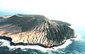
Montículo Cinerítico (front) and Bárcena (behind), volcanic cones on San Benedicto, one of the Revillagigedo Islands. Bárcena has existed only since 1952.
-
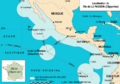
Location of Socorro Island and the rest of the Revillagigedo Archipelago, and extent of Mexico's western EEZ in the Pacific
-
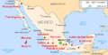
Socorro and Bárcena on San Benedicto are indicated on this map of Mexican volcanoes
-
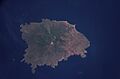
Socorro as seen from space. North is to the upper left corner.
-
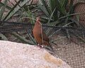
The Socorro dove (Zenaida graysoni), as of 2019, survives only in captivity
See also
 In Spanish: Archipiélago de Revillagigedo para niños
