Mulholland Highway facts for kids

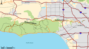
Map of Mulholland Drive (orange) and Mulholland Highway (brown) in Los Angeles County
|
|
| Namesake | William Mulholland |
|---|---|
| Tourist routes |
|
| West end | |
| Major junctions |
|
| East end | |

Mulholland Highway is a famous scenic road in Los Angeles County, California. It stretches for about 50 miles through the beautiful western Santa Monica Mountains. This road connects Calabasas near US Route 101 to Highway 1 (Pacific Coast Highway) near Malibu. It ends close to Leo Carrillo State Park and the Pacific Ocean.
Mulholland Highway is the more rural, western part of a longer scenic route. The eastern part is called Mulholland Drive. Both were named after William Mulholland, a civil engineer in Los Angeles. These roads were built in the 1920s to help people travel from the city to the ocean.
Some parts of Mulholland Highway are officially recognized as a California Scenic Highway. This means these sections pass through "memorable landscapes" with amazing views. People in the community really love these special parts of the highway.
Contents
Exploring Mulholland Highway
Mulholland Highway is about 30 miles long. It starts near Woodland Hills and goes all the way to Leo Carrillo State Park on the Pacific Coast Highway. This beautiful road was officially opened in 1928. It winds and turns through the Santa Monica Mountains, which are a range of hills in Southern California.
What You Can See Along the Way
As you travel along Mulholland Highway, you'll find many interesting things. The road gives you access to several regional parks within the Santa Monica Mountains National Recreation Area. These parks are great for hiking and exploring nature.
The highway runs east to west along the top of the Santa Monica Mountains. It offers amazing views of the canyons below. You can see the native plants that grow in this area all along the route.
Mulholland Drive: A Sister Road
Mulholland Drive is the eastern part of this famous route. In the early 1970s, many local people worked together to keep a large section of Mulholland Drive unpaved. This part is now known as "Dirt Mulholland." It's a special place only for cyclists and people walking.
East of the Mulholland Bridge, the paved Mulholland Drive winds through the fancy Hollywood Hills. It ends near Universal Studios at Cahuenga Boulevard. After that, it becomes an unpaved path again, leading towards Griffith Park.
See also
- Malibu Creek State Park
- The Rock Store
 | Tommie Smith |
 | Simone Manuel |
 | Shani Davis |
 | Simone Biles |
 | Alice Coachman |

