
Beaumont, California facts for kids
Quick facts for kids
Beaumont, California
|
|||
|---|---|---|---|
.jpg)
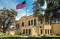
Beaumont Library in Beaumont
|
|||
|
|||

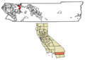
Location of Beaumont in Riverside County, California
|
|||

Beaumont, California
Location in southern California

Beaumont, California
Location in California

Beaumont, California
Location in the United States

Beaumont, California
Location in North America
|
|||
| Country | |||
| State | |||
| County | |||
| Incorporated | November 18, 1912 | ||
| Government | |||
| • Type | Council-Manager | ||
| Area | |||
| • Total | 30.33 sq mi (78.56 km2) | ||
| • Land | 30.32 sq mi (78.52 km2) | ||
| • Water | 0.01 sq mi (0.04 km2) 0.04% | ||
| Elevation | 2,612 ft (796 m) | ||
| Population
(2020)
|
|||
| • Total | 53,036 | ||
| • Density | 1,749.38/sq mi (675.43/km2) | ||
| Time zone | UTC−8 (PST) | ||
| • Summer (DST) | UTC−7 (PDT) | ||
| ZIP Code |
92223
|
||
| Area code | 951 | ||
| FIPS code | 06-04758 | ||
| GNIS feature IDs | 1660318, 2409805 | ||

Beaumont is a city in Riverside County, California, United States. It sits high up in the San Gorgonio Pass. This pass is a natural gap between two big mountain ranges. To the north are the San Bernardino Mountains and Mount San Gorgonio. To the south are the San Jacinto Mountains. You can even see Mount San Jacinto from the city. It's about 18 miles (30 kilometers) southeast of Beaumont.
Contents
History of Beaumont
What Does Beaumont Mean?
Beaumont is a French word. It means "Beautiful Mountain." The city got its name in 1887 from Henry C. Sigler. He was the president of a company called Southern California Investment Company. He chose the name because Mount San Jacinto is so close and easy to see from the city.
How Beaumont Started
The first people to live in this area were Native Americans.
In the early 1850s, groups explored the area where Beaumont is now. They were looking for a pass to connect the eastern United States to the Pacific Ocean. The San Gorgonio Pass was first explored in 1853. This was part of an expedition by Lieutenant R.S. Williamson. People soon realized a railway to the ocean was possible.
By the early 1860s, stagecoaches traveled through the pass. A stop was set up called Edgar Station. It was named after a doctor who lived there.

.jpg)
In 1875, the Southern Pacific Railroad built tracks here. They created a stop called Summit Station. It was a place for train travelers to rest. These travelers were coming from the Mojave Desert on their way to Los Angeles. In 1884, a company started a town called San Gorgonio. Another company bought the town in 1887. They renamed it Beaumont. The city officially became a city on November 18, 1912.
By 1927, Beaumont was a small city with 857 people. It had five churches, a public library, a bank, and a high school. It was known for growing apples. Locals called it "the land of the big red apple." By 1930, the apple industry was worth $200,000.
Beaumont became more popular as Palm Springs grew as a resort city. Beaumont also tried to attract tourists. It opened guest ranches. For example, the Highland Springs Guest Ranch offered many activities. These included horseback riding, tennis, swimming, and dancing.
Beaumont's Growth in the 1900s

During the Cold War, a rocket test site was built south of Beaumont. It was run by a company called Rocketdyne. In 2003, most of this site was sold to the state of California. The California Department of Fish and Game is planning to open it to the public.
Since 2000, many people have moved to the Beaumont area. This is because housing costs are lower here than in Los Angeles. This has caused a big jump in the city's population. Beaumont became one of the fastest-growing cities in California. This growth has led to more students in schools. It also means more demand for water and more traffic on Interstate 10. A study in 2008 showed that Beaumont's population was growing fast. It was expected to reach 310,000 by 2015.
Beaumont has many planned communities. These are neighborhoods built with specific designs. Some of these include Oak Valley Greens, Three Rings Ranch, and Sundance. These communities often have homeowner associations (HOAs).
Geography of Beaumont
Beaumont is next to Banning to the east. It is also next to Calimesa to the northwest.
The city is about 2,500 to 3,000 feet (762 to 914 meters) above sea level. It is at the highest point of the San Gorgonio Pass. This pass is between San Bernardino and Palm Springs. Major highways like Interstate 10 and State Route 60 pass through Beaumont. If you drive east or west, you will notice a gradual downhill slope.
The United States Census Bureau says Beaumont covers about 30.9 square miles (79.9 square kilometers). Almost all of this area is land. Only a tiny part is water.
Beaumont's Climate
Beaumont has hot summers and mild winters. In summer, the average high temperature is about 95°F (35°C). In winter, the average low is about 38°F (3°C). Because it's higher up, Beaumont is usually 5-10°F (3-6°C) cooler than nearby cities. These include Moreno Valley and Palm Springs. Snow can fall, but it usually melts quickly.
Beaumont has a Hot-summer Mediterranean climate. This means it has hot, dry summers and mild, wet winters. The cooler temperatures and cleaner air make it a nice place to live. However, Beaumont is one of the windiest cities in Southern California.
The city gets about 19.3 inches (489.8 mm) of rain each year.
| Climate data for Beaumont, California, 1981–2010 normals, extremes 1939–2010 | |||||||||||||
|---|---|---|---|---|---|---|---|---|---|---|---|---|---|
| Month | Jan | Feb | Mar | Apr | May | Jun | Jul | Aug | Sep | Oct | Nov | Dec | Year |
| Record high °F (°C) | 83 (28) |
88 (31) |
95 (35) |
100 (38) |
111 (44) |
109 (43) |
114 (46) |
113 (45) |
112 (44) |
106 (41) |
94 (34) |
86 (30) |
114 (46) |
| Mean daily maximum °F (°C) | 63.1 (17.3) |
64.5 (18.1) |
68.6 (20.3) |
74.3 (23.5) |
80.9 (27.2) |
89.4 (31.9) |
96.3 (35.7) |
96.8 (36.0) |
91.5 (33.1) |
81.2 (27.3) |
70.8 (21.6) |
62.6 (17.0) |
78.3 (25.8) |
| Daily mean °F (°C) | 51.9 (11.1) |
52.6 (11.4) |
55.2 (12.9) |
59.4 (15.2) |
65.5 (18.6) |
71.9 (22.2) |
78.3 (25.7) |
78.7 (25.9) |
74.2 (23.4) |
65.6 (18.7) |
57.6 (14.2) |
51.2 (10.7) |
63.5 (17.5) |
| Mean daily minimum °F (°C) | 40.6 (4.8) |
40.7 (4.8) |
41.7 (5.4) |
44.5 (6.9) |
50.1 (10.1) |
54.4 (12.4) |
60.2 (15.7) |
60.6 (15.9) |
56.9 (13.8) |
50.0 (10.0) |
44.4 (6.9) |
39.7 (4.3) |
48.7 (9.3) |
| Record low °F (°C) | 11 (−12) |
19 (−7) |
21 (−6) |
25 (−4) |
31 (−1) |
35 (2) |
42 (6) |
38 (3) |
37 (3) |
29 (−2) |
20 (−7) |
20 (−7) |
11 (−12) |
| Average precipitation inches (mm) | 3.91 (99) |
4.29 (109) |
3.09 (78) |
1.19 (30) |
0.65 (17) |
0.17 (4.3) |
0.35 (8.9) |
0.26 (6.6) |
0.49 (12) |
1.03 (26) |
1.57 (40) |
2.33 (59) |
19.33 (489.8) |
| Average snowfall inches (cm) | 0.0 (0.0) |
0.7 (1.8) |
trace | 0.0 (0.0) |
0.0 (0.0) |
0.0 (0.0) |
0.0 (0.0) |
0.0 (0.0) |
0.0 (0.0) |
0.0 (0.0) |
0.1 (0.25) |
0.5 (1.3) |
1.3 (3.35) |
| Average precipitation days (≥ 0.01 in) | 6.6 | 6.9 | 7.0 | 4.4 | 3.0 | 1.2 | 1.2 | 1.4 | 1.8 | 2.6 | 3.5 | 5.1 | 44.7 |
| Average snowy days (≥ 0.1 in) | 0.0 | 0.3 | 0.1 | 0.0 | 0.0 | 0.0 | 0.0 | 0.0 | 0.0 | 0.0 | 0.1 | 0.2 | 0.7 |
| Source 1: NOAA | |||||||||||||
| Source 2: National Weather Service | |||||||||||||
People in Beaumont
| Historical population | |||
|---|---|---|---|
| Census | Pop. | %± | |
| 1920 | 857 | — | |
| 1930 | 1,332 | 55.4% | |
| 1940 | 2,208 | 65.8% | |
| 1950 | 3,152 | 42.8% | |
| 1960 | 4,288 | 36.0% | |
| 1970 | 5,484 | 27.9% | |
| 1980 | 6,818 | 24.3% | |
| 1990 | 9,685 | 42.1% | |
| 2000 | 11,384 | 17.5% | |
| 2010 | 36,877 | 223.9% | |
| 2020 | 53,036 | 43.8% | |
| U.S. Decennial Census | |||
2010 Census Information
In 2010, Beaumont had 36,877 people. The city had about 1,192 people per square mile. Most residents were White (62.8%). About 6.2% were African American, and 7.7% were Asian. About 16.4% were from other races. People of Hispanic or Latino background made up 40.3% of the population.
Most people (98.7%) lived in homes. There were 11,801 households. About 45.3% of these had children under 18. Many households (60.6%) were married couples. The average household had about 3 people.
About 30.2% of the people were under 18 years old. About 10.5% were 65 or older. The average age was 32.5 years. For every 100 females, there were about 95 males.
Most homes (75.0%) were owned by the people living in them. The rest were rented. In 2010, the average household income was $67,758. About 11.2% of the population lived below the poverty line.
2000 Census Information
In 2000, Beaumont had 11,384 people. There were about 419 people per square mile. The racial makeup was mostly White (68.1%). About 2.9% were African American, and 1.7% were Asian. About 20.3% were from other races. People of Hispanic or Latino background made up 36.2% of the population.
There were 3,881 households. About 42.6% of these had children under 18. Many households (47.3%) were married couples. The average household had about 2.9 people.
About 33.0% of the people were under 18. About 10.7% were 65 or older. The average age was 30 years. For every 100 females, there were about 91 males.
In 2007, the average household income was $40,295. About 20.2% of the population lived below the poverty line. This included 28.9% of those under 18.
Beaumont's Economy
Beaumont has several large stores. These are located in the 2nd Street Marketplace. You can find many chain stores, restaurants, and a movie theater there.
Arts and Fun
The Beaumont Library District provides library services. It serves Beaumont and Cherry Valley. This library is a special district, separate from the city government.
Parks and Activities
The city's Parks and Recreation Department offers many activities. The Beaumont-Cherry Valley Recreation and Park District also provides services.
You can find two golf courses in the area. These are the Tukwet Canyon and Oak Valley Golf Clubs.
The nearby Highland Springs Resort was started in 1884. It has a large organic lavender farm. They host a Lavender Festival in June. They also have a Sausage and Beer Festival in August. An Olive & Wine Faire takes place in October. Beaumont also hosts its own Annual Cherry Festival. It celebrated its 100th anniversary in 2018.
Schools in Beaumont
The Beaumont Unified School District manages schools in the city. It also covers schools in Cherry Valley.
- High Schools: Beaumont, Glen View (continuation school)
- Middle Schools: Mountain View, San Gorgonio
- K-8 Schools: Summerwind Trails
- Elementary Schools: Anna Hause, Brookside, Highland Springs, Palm Avenue, Sundance, Starlight, Three Rings Ranch and Tournament Hills
There is also Highland Academy Charter School. It follows the district's rules but is not officially part of it. Some parts of Beaumont are in the Banning Unified School District or the San Jacinto Unified School District.
City Buildings

Famous People from Beaumont
- Tracy Caldwell Dyson: A NASA astronaut. She graduated from Beaumont High School in 1987.
- Scott Haskin: A professional basketball player who grew up in Beaumont.
- Brion James: An actor.
- George Wagner: A professional wrestler known as "Gorgeous George." He owned a large turkey ranch in Beaumont.
- Amir Zaki: An American artist known for his photography and video art.
Images for kids
-
Beaumont Library in Beaumont
-
City Seal of Beaumont
-

City Logo of Beaumont
-
Location of Beaumont in Riverside County, California
See also
 In Spanish: Beaumont (California) para niños
