Calimesa, California facts for kids
Quick facts for kids
City of Calimesa
|
|||
|---|---|---|---|

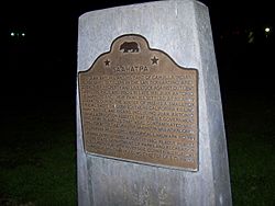
Saahatpa plaque
|
|||
|
|||

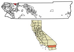
Location of Calimesa in Riverside County, California.
|
|||
| Country | |||
| State | |||
| County | |||
| Incorporated (city) | December 1, 1990 | ||
| Government | |||
| • Type | Council-Manager | ||
| Area | |||
| • Total | 14.87 sq mi (38.50 km2) | ||
| • Land | 14.87 sq mi (38.50 km2) | ||
| • Water | 0.00 sq mi (0.00 km2) 0% | ||
| Elevation | 2,392 ft (729 m) | ||
| Population
(2020)
|
|||
| • Total | 10,026 | ||
| • Density | 674.38/sq mi (260.39/km2) | ||
| Time zone | UTC-8 (PST) | ||
| • Summer (DST) | UTC-7 (PDT) | ||
| ZIP code |
92320
|
||
| Area code(s) | 909 | ||
| FIPS code | 06-09864 | ||
| GNIS feature IDs | 1667904, 2409961 | ||
Calimesa is a city in Riverside County, California, in the United States. Its name is a mix of "California" and "Mesa." "Mesa" is a Spanish word meaning "table" or "table-land." This name describes the flat, elevated land where the city is located.
Calimesa is part of the Greater Los Angeles area. It sits in the San Gorgonio Pass, a mountain pass that connects different parts of California. In 2020, about 10,026 people lived in Calimesa.
Contents
Discovering Calimesa's Past
How Calimesa Got Its Name
Calimesa started as a small, quiet town with many homes and ranches. When a major road, U.S. Route 99 (now I-10), was finished, more businesses opened. This helped Calimesa become its own community, separate from the nearby town of Yucaipa.
In 1929, residents held a meeting to get their own post office. They also started a contest to name their new community. "Calimesa" was chosen from 107 names. The name combines "Cali" from California and "mesa," the Spanish word for "table" or "table-lands." The first post office was inside a grocery store.
Early Days of the Area
Long ago, the Serrano people and Cahuilla people lived in this area.
Modern history began when Spanish missions were built in California in 1769. These missions needed a land route to connect them. In 1774, Captain Juan Bautista de Anza led a group through this area. By 1820, there was a path for messengers. This path connected missions in Arizona to the San Gabriel Mission near Los Angeles.
Parts of the Rancho San Gorgonio were along this path. Places like Highland Springs Ranch & Inn became stops for travelers.
Building a Community Together
Having its own post office made residents feel like a true community. In the late 1930s, the Calimesa Improvement Association was formed. This group worked to improve Calimesa and help the community grow.
Volunteers built a community center. It was on land set aside for a park. The "South Mesa Water Company" bought land for a well and let the association use it for events.
In 1962, the Improvement Association became the Calimesa Chamber of Commerce. This group has always worked to promote Calimesa. They also provide community services and help residents with problems. Before 1949, fire protection came from a state department. But Calimesa residents wanted more local help. So, in 1949, they started their own Volunteer Fire Department.
Becoming an Official City
Calimesa officially became a city on December 1, 1990. This happened soon after its neighbor, Yucaipa, also became a city. Before this, Calimesa was a town without its own city government. It was located where Interstate 10 goes up the San Gorgonio Pass.
What's Next for Calimesa?
In recent years, several large housing projects have been approved for Calimesa. These include thousands of new homes and commercial areas. The number of approved homes is more than the city's current population. However, these large projects are being built slowly. They will move forward as more people want to live in the area.
Getting Around Calimesa
The main road through Calimesa is Interstate 10. This highway runs north to south through the city. Other important roads include County Line Road, Sandalwood Drive, and Cherry Valley Boulevard. These roads run east and west from the freeway. Calimesa Boulevard runs north and south, parallel to the freeway.
Calimesa does not have its own airport. There are also no direct train lines in the city.
Calimesa's Location and Landscape
Calimesa is in the northwest part of Riverside County. It is located between the cities of Yucaipa and Beaumont. The city is in the Yucaipa Valley, which is part of Southern California's Inland Valley. It sits at the western edge of the San Gorgonio Pass. This pass is between the cities of San Bernardino and Palm Springs. Calimesa is part of a larger region called the Inland Empire.
The city is in the foothills of the San Bernardino Mountains. The land in Calimesa is between 2,300 and 3,500 feet (about 700 to 1,067 meters) above sea level.
The United States Census Bureau says that Calimesa covers about 14.8 square miles (38.5 square kilometers). All of this area is land.
City Borders and Neighbors
Historically, the Wildwood Canyon Wash separated Calimesa from Yucaipa. Today, "County Line Road" often marks the border between the two towns. However, some areas traditionally known as "Calimesa" are actually inside Yucaipa's city limits. This includes Calimesa Elementary School.
State law does not allow cities to cross county lines when they incorporate. So, when Calimesa became a city, it could not include all the areas people thought of as "Calimesa." When Yucaipa became a city, it included some of these areas. This was done to avoid leaving gaps of land without a city government. Even though they are in different counties, Yucaipa and Calimesa share many street names and a similar road layout.
Calimesa's city limits also reach south to the city of Beaumont, California. The border between Calimesa and Beaumont generally follows an electrical power line path. Near Interstate 10, Champions Drive is a common boundary between the two cities.
Who Lives in Calimesa?
| Historical population | |||
|---|---|---|---|
| Census | Pop. | %± | |
| 1990 | 4,647 | — | |
| 2000 | 7,139 | 53.6% | |
| 2010 | 7,879 | 10.4% | |
| 2020 | 10,026 | 27.2% | |
| U.S. Decennial Census | |||
Calimesa's Population in 2010
In 2010, Calimesa had a population of 7,879 people. Most residents, about 86%, were White. About 22.4% of the population identified as Hispanic or Latino.
Most people (99.4%) lived in homes with families or housemates. There were 3,314 households in total. About 23.3% of these households had children under 18. Many households (48.6%) were married couples living together. The average household had about 2.36 people.
The median age in Calimesa was 48.8 years old. This means half the people were younger than 48.8, and half were older. About 17.9% of the population was under 18. About 25.9% of residents were 65 or older.
Most homes (80.7%) were owned by the people living in them. About 19.3% of homes were rented.
In 2010, the typical household income in Calimesa was $44,817 per year. About 14.5% of the population lived below the poverty line.
Calimesa's Population in 2000
In 2000, Calimesa had 7,139 people living in 2,982 households. The population density was about 458 people per square mile.
About 89.1% of the people were White. About 14.1% of the population was Hispanic or Latino.
About 24.2% of households had children under 18. Many households (54.3%) were married couples. The average household size was 2.36 people.
The median age in 2000 was 44 years. About 21.8% of residents were under 18. About 26% were 65 or older.
The typical household income in 2000 was $37,849. About 12.2% of the population lived below the poverty line.
Learning in Calimesa
Public schools for most children in Calimesa are part of the Yucaipa-Calimesa Joint Unified School District. Some areas in the very south of the city are served by the Beaumont Unified School District.
Schools in the Area
Calimesa is covered by two school districts. The Yucaipa-Calimesa Joint Unified School District serves the western part of the city. The Beaumont Unified School District serves the southeastern part.
Currently, there is one public school in Calimesa: Mesa View Middle School. It opened in 2009. This school was planned to be a high school. However, because fewer new homes were built, the district decided to keep it as a middle school for now.
Calimesa Elementary School is actually located in the city of Yucaipa. High school students from Calimesa usually attend Yucaipa High School. Calimesa also has a private school called Mesa Grande Academy. It is a K-12 school run by the Seventh-day Adventist Church.
For college, the closest community college is Crafton Hills College in Yucaipa.
See also
 In Spanish: Calimesa para niños
 | Frances Mary Albrier |
 | Whitney Young |
 | Muhammad Ali |


