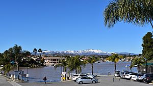
Elsinore Mountains facts for kids
The Elsinore Mountains are a long line of mountains. They are part of the bigger Santa Ana Mountains range. You can find them in the Cleveland National Forest in Riverside County, California, United States.
These mountains are like a natural wall. They stretch from near El Cariso in the northwest, all the way southeast to Elsinore Peak. After Elsinore Peak, the mountains get lower and curve towards the east.
Contents
Tallest Peaks in the Elsinore Mountains
The Elsinore Mountains have two main tall points. These are like their highest shoulders!
San Mateo Peak
The very tallest spot is called San Mateo Peak. It's not officially named on maps, but everyone knows it. This peak stands about 3,591 feet (1,095 meters) high.
Elsinore Peak
The second highest point is Elsinore Peak. This one is officially named. It reaches about 3,536 feet (1,078 meters) into the sky. From Elsinore Peak, another ridge of mountains goes west and then northwest. This creates a natural bowl called the Morrell Potrero to its south and west.
Water Flowing from the Mountains
The Elsinore Mountains are important for water. Many small streams start here.
Western Slopes
On the western side of the mountains, streams like Decker Canyon Creek, Morrell Canyon Creek, and San Mateo Creek begin. These streams eventually flow into San Juan Creek and then San Mateo Creek.
Southern Slopes
The southern parts of the mountains also have streams. Los Alamos Canyon Creek and its helper, Wildhorse Canyon Creek, start here. They also flow into San Mateo Creek.
Eastern Slopes
The streams on the eastern side are a bit different. They are often "ephemeral," meaning they only flow after it rains. Most of these streams drain into Lake Elsinore. Lake Elsinore then connects to the Santa Ana River. However, on the far southeastern part of the ridge, the streams flow into Murrieta Creek, which is part of the Santa Margarita River system.
 | James B. Knighten |
 | Azellia White |
 | Willa Brown |


