Santiago Creek facts for kids
Quick facts for kids Santiago Creek |
|
|---|---|

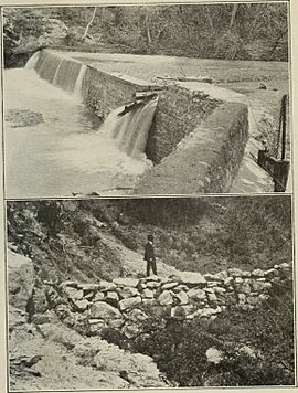
Low rock dam on Santiago Creek in Irvine Regional Park (c. 1917)
|
|

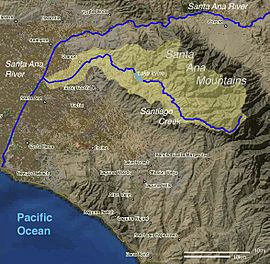
Map of the Santiago Creek watershed and surroundings
|
|
| Other name(s) | Cañada de Madera |
| Country | United States |
| State | California |
| County | Orange |
| District | Cleveland National Forest |
| Municipality | Orange |
| Physical characteristics | |
| Main source | Santiago Peak Cleveland National Forest 4,870 ft (1,480 m) 33°42′58″N 117°32′21″W / 33.71611°N 117.53917°W |
| River mouth | Santa Ana River Santa Ana 108 ft (33 m) 33°46′11″N 117°53′27″W / 33.76972°N 117.89083°W |
| Length | 34 mi (55 km) |
| Basin features | |
| Basin size | 100.6 sq mi (261 km2) |
| Tributaries |
|
Santiago Creek is a major stream in Orange County, California. It is about 34 miles (55 km) long. This creek drains most of the northern Santa Ana Mountains. It flows into the Santa Ana River. Santiago Creek is one of the longest streams that stays completely within Orange County. It is named after Santiago Peak, the highest point in Orange County.
The area of land that Santiago Creek drains is called its watershed. This watershed covers about 100.6 square miles (261 km2) in northern Orange County. The upper part of the creek flows freely through nature. The lower part flows through cities like Tustin, Orange, and Santa Ana. Below the Villa Park Dam, the creek is mostly a channel. Water usually flows here only during heavy winter storms.
Long ago, Santiago Creek provided water for the Tongva people. Their land covered much of northern Orange County. Native Americans lived near Santiago Creek for up to 12,000 years. Spanish explorers named the creek in 1769. This was during the Gaspar de Portolá expedition. In the 1870s, people found silver near Silverado Creek. In 1929, the Santiago Dam was built. This dam created Irvine Lake to help farmers water their crops.
Contents
Where Does Santiago Creek Flow?
Santiago Creek starts in the Cleveland National Forest. It begins between Santiago Peak and Modjeska Peak. These two peaks form a famous shape called the Saddleback. The creek flows south, then turns northwest. It leaves the national forest and passes through Modjeska. Here, it meets its first big side stream, Harding Canyon Creek.
Further downstream, it gets water from Baker and Silverado creeks. After crossing Santiago Canyon Road, the valley gets wider. Here, the creek's water usually flows underground. You can only see it on the surface during wet seasons.
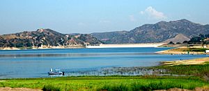
The creek then flows into Irvine Lake. This lake also gets water from Limestone Canyon. The lake is about 700-acre (280 ha) big. It is held back by the 110-foot (34 m) Santiago Dam. Irvine Lake provides water to Villa Park and Orange. Because of the dam, the creek below it is often dry.
Below the dam, the dry creek bed meets Fremont Canyon. It then goes under California State Route 241. It flows northwest through Irvine Regional Park. Here, it gets water from Weir Canyon Creek. Near Villa Park, the Villa Park Dam helps control floods. For its last 7 miles (11 km), the creek flows in a special channel. It flows between Orange and Santa Ana. It receives Handy Creek and goes under highways. Parts of the dry creek bed are even used as parking lots sometimes! Finally, it flows into the Santa Ana River. The Santa Ana River reaches the Pacific Ocean about 10 miles (16 km) later.
What is the Santiago Creek Watershed?
A watershed is an area of land where all the water drains into one main river or stream. The Santiago Creek watershed is in the northwestern part of the Santa Ana Mountains. It is mostly north of Irvine. This watershed is about 100.6 square miles (261 km2) in size. It makes up about 3.6% of the entire Santa Ana River watershed.
The land in the watershed ranges from 5,687 feet (1,733 m) high at Santiago Peak to 108 feet (33 m) low where it meets the Santa Ana River. Most of the watershed is in Orange County. However, small parts are close to Riverside and San Bernardino counties.
Santiago Creek's Tributaries
Santiago Creek has 10 main side streams, called tributaries. Most of these join the creek in Santiago Canyon. Fremont Canyon is the longest tributary. Silverado Canyon covers the largest area. Many of the upper tributaries have water flowing all year round.
| Tributary name | Length | Size | |
|---|---|---|---|
| Denomination | Miles | Kilometers | Rank |
|
|
|||
| Harding Canyon (R) | 3.5 | 5.6 | 6 |
| Williams Canyon (R) | 1.3 | 2.1 | 10 |
| Silverado Canyon (R) | 10.8 | 17.3 | 1 |
| Ladd Canyon (Silverado Canyon tributary) (R) |
4.2 | 6.7 | 4 |
| Baker Canyon (R) | 5.5 | 8.9 | 8 |
| Black Star Canyon (R) | 8.5 | 13.7 | 3 |
|
|
|||
| Limestone Canyon (L) | 8.7 | 14.0 | 5 |
|
|
|||
| Fremont Canyon (R) | 12.0 | 19.3 | 2 |
| Blind Canyon (R) | 2.4 | 3.9 | 11 |
| Weir Canyon (R) | 4.6 | 7.4 | 9 |
| Handy Creek (L) | 6.0 | 9.65 | 7 |
|
|
|||
How Was Santiago Creek Formed?
The main geological feature in the Santiago Creek watershed is the Santa Ana Mountains. The northern part of these mountains, where Santiago Creek flows, has rocks from very old times. These rocks are mostly slate, sandstone, and limestone. The Santa Ana Mountains began to rise about 5.5 million years ago. This happened along a major crack in the Earth's crust called the Elsinore Fault Zone.
Santiago Creek's History
Before the late 1800s, Santiago Creek flowed freely all year. It wound through a wide, flat area to meet the Santa Ana River. Many trees like coast live oaks and California sycamores grew along its banks. This area was home to many birds, fish, insects, and mammals.
Native American Life Along the Creek
Most of the creek was in the territory of the Acjachemen and Tongva peoples. These were two large Native American groups. The Acjachemen lived to the south, and the Tongva to the north. Native Americans built villages near the running water. They ate mostly acorns, grinding them into a porridge. You can still see some of their grinding stones in the canyon.
Spanish Explorers and Settlers
In 1769, Spanish explorers traveled along the Santa Ana Mountains. They camped near Santiago Creek on July 27. A priest named Juan Crespi wrote that the creek was named after Santiago el Mayor. Later, the Spanish called the canyon Cañada de Madera, meaning "timber canyon." The mountain where the creek starts was renamed Santiago Peak.
One of the first Spanish settlers was Jose Pablo Grijalva. He started raising cattle in the canyon in the 1790s. He built a house by the creek in 1796. Other settlers followed.
Ranchos and Early Conflicts
Large ranches were granted in the creek's area. These included Rancho Santiago de Santa Ana (1810), Rancho San Joaquin (1837), and Rancho Lomas de Santiago (1846). Parts of these ranches later became the Irvine Ranch.
In 1831, a sad event happened in Black Star Canyon. It was called Cañada de los Indios (Indian Canyon). American fur trappers followed stolen horses to a Tongva village. Many Native Americans were killed in the conflict that followed. The site is now a California Historical Landmark.
American Era and Mining
In 1877, silver was found in Silverado Canyon. Many mines opened, and a town called Silverado grew. The biggest mine was the Blue Light Mine. Mining continued for decades. The last big mining stopped in the 1940s. The mine still releases small amounts of harmful metals like arsenic and lead. Cleanup efforts began in 2008.
Modjeska House
In 1883, a Polish actress named Helena Modjeska bought a ranch in Santiago Canyon. She had a beautiful country house designed there. She lived on this estate, called Arden, until 1906. Modjeska Peak was named in her honor.
Water Supply and Dams
By the 1920s, the area around Orange and Anaheim was growing. Farmers needed water from Santiago Creek. But the creek would flood in winter and dry up in summer. So, in 1928, the Serrano Irrigation District was formed. They worked with the Irvine Company to build the Santiago Dam.
The dam was finished in 1931, creating Irvine Lake. This lake helped farmers water their crops. Today, Villa Park and parts of Orange still get water from Irvine Lake.
Villa Park Dam
The Villa Park Dam was built further downstream in 1963. It helps control floods. The lower part of Santiago Creek was turned into a channel in the mid-1900s to prevent flooding. The Orange County Flood Control Division now owns the dam.
What Animals Live in Santiago Creek?
Long ago, Santiago Creek had many plants and animals along its banks. Large animals like California grizzly bears (now extinct) and mountain lions lived here. Today, the upper part of Santiago Creek is still natural. But the lower part is very changed by cities. It does not have as many native plants and animals.
The creek used to have steelhead trout. These fish would swim from the ocean to lay eggs. But the dams stopped them from doing this. However, some rainbow trout have been found in Harding Canyon. These are a type of steelhead that live only in fresh water. They are believed to be native fish.
Fun Things to Do at Santiago Creek

There are many fun things to do along Santiago Creek and at its lakes:
- Lake Irvine: This lake opened for fishing in 1941. You don't need a special license to fish here. The lake is stocked with fish every week.
- Irvine Regional Park: This park was created in 1897. It covers much of the lower Santiago Creek Canyon. It started as 160 acres (0.65 km2) of woodland. Now it is 477 acres (1.93 km2) big. You can go hiking, fishing, boating, and visit a small zoo.
- Cleveland National Forest: The upper part of Santiago Creek is in this forest. It was created in 1908. You can find many hiking trails here. Some trails go up steep canyons like Black Star Canyon and Silverado Canyon. The Joplin Trail leads to the top of Modjeska Peak.
Other Fun Places to Visit
There are other parks and natural areas in the Santiago Creek area:
- Santiago Oaks Regional Park
- Barham Ranch (part of Santiago Oaks Regional Park)
- Tucker Wildlife Sanctuary
- 'Arden'—Helena Modjeska estate
- Irvine Ranch Open Space
- Irvine Ranch Land Reserve
- El Modena Open Space
- El Modena High School Nature Center
- Black Star Canyon, Limestone Canyon, Baker Canyon, Fremont Canyon, and Irvine Mesa
- Hidden Ranch
- Santa Ana River Trail
- Yorba Regional Park
- Grijalva Park at Santiago Creek
- Wo Hart Memorial Park
- Santiago Park Nature Reserve
 | John T. Biggers |
 | Thomas Blackshear |
 | Mark Bradford |
 | Beverly Buchanan |


