Silverado Canyon facts for kids
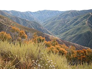
Silverado Canyon is a deep valley, about 2,500 feet (760 meters) deep, located in the Santa Ana Mountains in California. A small stream called Silverado Creek starts high up on Modjeska Peak (about 3,980 feet or 1,213 meters high). It flows north and west, past the town of Silverado, for almost 5 miles (8 kilometers) before joining Santiago Creek.
Another important part of the canyon is Ladd Canyon, which is over 3 miles (5 kilometers) long. Its stream begins on the side of Pleasants Peak (about 3,590 feet or 1,094 meters high) and flows into the main Silverado Creek. Both creeks are part of the larger Santa Ana River watershed, which means their water eventually flows into the Santa Ana River. There's a hiking trail and fire road that runs through the whole canyon.
Contents
Exploring Silverado Canyon
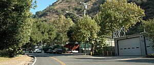
The small town of Silverado is nestled inside the canyon. Most of its buildings are located where the canyon opens up into a wider valley. Further into the canyon, a gate marks the entrance to the Cleveland National Forest. The town is mainly a place where people live, but it also has a few small stores.
Tall mountains surround the canyon. To the south, you can see Modjeska Peak, which is part of a larger mountain area called Saddleback, rising to 5,498 feet (1,676 meters). To the east, Bald Peak forms the end of the canyon at 3,947 feet (1,203 meters). To the north, Bedford Peak stands tall at 3,800 feet (1,158 meters).
Silverado Creek's Flow
Silverado Creek usually flows during the winter and dries up in the summer. It has the most water in winter and early spring. As the year goes on, it becomes a small trickle or dries up completely. Sometimes, it even dries up near the Forest Service gate. By the time it reaches the lower end of Silverado town, it's usually dry.
Why "Silverado"?
The canyon got its name because silver mines used to operate in this area a long time ago. You can still see leftover rock piles from the Blue Light Mine on the south side of the canyon. Old mines can be dangerous because the air inside them might not have enough oxygen, making it unsafe to explore.
The Canyon Road: Safety First
There is a gate at the end of the paved road in Silverado Canyon, which leads to a dirt access road. This gate is usually closed for most of the year. Even if a website says the gate is open, it's a good idea to check, as the information might not be updated often.
This dirt road is steep and can be very rough, with sharp rocks that can cause flat tires. If you ever drive on it, you should always have a full-size spare tire that is properly inflated. The road's condition changes a lot throughout the year. It might be smooth after being fixed, but it's often full of ruts (deep grooves). The gate is usually closed when it rains because the road can get washed out or trees can fall. It often stays closed for several weeks after rain while the Forest Service clears and repairs it. Hiking on this road when the gate is open and vehicles are using it is not recommended because of the danger from cars.
 | Jessica Watkins |
 | Robert Henry Lawrence Jr. |
 | Mae Jemison |
 | Sian Proctor |
 | Guion Bluford |


