Acton, California facts for kids
Quick facts for kids
Acton, California
|
|
|---|---|

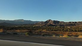
View of Acton and the surrounding valley from Route 14, with Mt. Gleason and the San Gabriel Mountains in the background
|
|

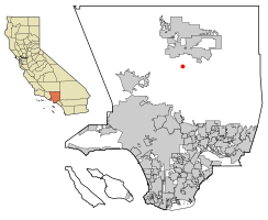
Location of Acton in Los Angeles County, California
|
|
| Country | |
| State | |
| County | |
| Named for | Acton, Massachusetts |
| Area | |
| • Total | 39.28 sq mi (101.74 km2) |
| • Land | 39.26 sq mi (101.68 km2) |
| • Water | 0.02 sq mi (0.06 km2) 0.06% |
| Elevation | 2,710 ft (826 m) |
| Population
(2020)
|
|
| • Total | 7,431 |
| • Density | 189.28/sq mi (73.08/km2) |
| Time zone | UTC−8 (Pacific) |
| • Summer (DST) | UTC−7 (PDT) |
| ZIP Code |
93510
|
| Area code | 661 |
| FIPS code | 06-00212 |
| GNIS feature IDs | 1660228, 2407697 |
Acton () is a small community in Los Angeles County, California. It is called a census-designated place because it is not officially a city, but the government counts its population. Acton is located near the Antelope Valley. In 2020, about 7,431 people lived there.
Acton is nestled between the Sierra Pelona Mountains and the San Gabriel Mountains. You can find it off the Antelope Valley Freeway (California State Route 14), south of Palmdale. It's about 20 miles (32 km) northeast of the San Fernando Valley. It is also about 47 miles (76 km) north of downtown Los Angeles by highway.
The town has a cool rural western feel. You can see this in its homes and older buildings. Some buildings are from the late 1800s. Many homes in the mountains have great views of the valley. In the valley, you'll find ranch-style homes. These often have places for horses. Acton has a Metrolink train station. It looks like an "old western" station. This station has even been in movies and commercials!
Contents
Acton's Past: A Look at Its History
Acton started as a camp for railroad workers. This was from 1873 to 1876. They were building the Southern Pacific Railroad at that time.
Long ago, some people thought Acton could become the State capital of California. California Governor Henry T. Gage (who was governor from 1899 to 1903) owned a mine in Acton. He tried to move the capital here from Sacramento. But his plan did not work out.
In the late 1880s, Acton became more of a place for farms and ranches. In 1889, Acton got its first hotel. It also got its first saloon, called the "49er". This saloon is still open today!
Where is Acton? Exploring Its Geography
Acton is located at 34°28′22″N 118°11′1″W / 34.47278°N 118.18361°W. It is about 20 miles (32 km) east of Santa Clarita. It is also about 8 miles (13 km) south of Palmdale. The area of Acton is about 39.3 square miles (101.8 square kilometers). Almost all of this area is land.
Mount Gleason is a tall peak in the San Gabriel Mountains. It is about 7 miles (11 km) south of Acton. You can see this mountain from the town. You can also see it when you drive on Highway 14.
Acton's Weather: A Warm-Summer Climate
Acton has a type of weather called a warm-summer Mediterranean climate. This means it has warm, dry summers. The average monthly temperatures are not extremely hot.
Summer daytime temperatures usually average around 88°F (31°C) or higher.
Who Lives in Acton? A Look at Its People
| Historical population | |||
|---|---|---|---|
| Census | Pop. | %± | |
| 1990 | 1,471 | — | |
| 2000 | 2,390 | 62.5% | |
| 2010 | 7,596 | 217.8% | |
| 2020 | 7,431 | −2.2% | |
| U.S. Decennial Census 1850–1870 1880-1890 1900 1910 1920 1930 1940 1950 1960 1970 1980 1990 2000 2010 |
|||
In 2010, the 2010 United States census counted 7,596 people living in Acton. Most people in Acton are White. About 18% of the people are Hispanic or Latino.
All 7,596 people lived in homes. There were 2,660 households in total. About 34% of these homes had children under 18 living there. Most homes (about 67%) were married couples. The average household had about 2.86 people.
The population has people of all ages. About 22% of the people were under 18 years old. About 40% were between 45 and 64 years old. The average age in Acton was 45.5 years.
Most homes in Acton (about 90%) are owned by the people who live in them. Only about 10% of homes are rented.
Family Backgrounds in Acton
According to a project called Mapping L.A., many people in Acton have German and Irish family backgrounds. Many people born outside the U.S. came from Mexico and Canada.
Acton's Work and Money: The Economy
In 2015, the average person working in Acton earned about $75,714. This was more than the average for the whole United States. Men in Acton generally earned more than women.
About 22% of people in Acton work for themselves. This is twice the U.S. average. Only a small number of people (6.9%) in Acton live in poverty. Very few households (1%) use public assistance.
Many people in Acton travel a long time to get to work. The average commute is 46 minutes. This is much longer than the U.S. average of 26 minutes. However, about 12% of Acton workers can work from home. This is higher than the U.S. average.
Fun Things to Do: Parks and Recreation
Acton has some interesting places for animals and outdoor activities.
Farm Sanctuary
Farm Sanctuary was started in Acton in 1986. It was the first place in America to give shelter to farmed animals. These are animals like cows, pigs, and chickens.
Shambala Preserve
The Shambala Preserve is a special wild animal park. It is run by actress Tippi Hedren. It is located near Acton. This preserve is like an authentic African-style home for over 70 wild animals. You can find African lions, Royal Bengal and Siberian tigers, spotted and black leopards, cougars, and even African elephants there.
Parker Mountain
Acton is also home to Parker Mountain. This mountain is famous for a type of radio-controlled aircraft flying called "dynamic soaring". At one time, a world speed record of 302 miles per hour (486 km/h) was set here!
Learning in Acton: Education
Acton is part of the Acton-Agua Dulce Unified School District. There are three schools in Acton:
- Meadowlark Elementary School
- High Desert Middle School
- Vasquez High School
How Acton Works: Infrastructure
The Los Angeles County Department of Health Services helps people in Acton. They run the Antelope Valley Health Center in Lancaster.
See also
 In Spanish: Acton (California) para niños
 | Selma Burke |
 | Pauline Powell Burns |
 | Frederick J. Brown |
 | Robert Blackburn |


