Soledad Canyon facts for kids

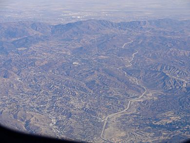
Soledad Canyon is a long, narrow valley in Los Angeles County, California. It sits between the cities of Palmdale and Santa Clarita. This canyon is part of the larger Santa Clara River Valley. It stretches from the top of Soledad Pass down to the open area of the Valley in Valencia. The Santa Clara River flows through the upper part of the canyon.
Contents
Exploring Soledad Canyon's Geography
This canyon is located between two mountain ranges. To the northwest are the Sierra Pelona Mountains. To the southeast are the San Gabriel Mountains. Soledad Canyon begins at the northeast end of the Santa Clarita Valley.
As you travel northeast through the canyon, the land slowly rises. It continues this way until you reach the community of Acton. Near Acton, the Santa Clara River keeps flowing east. Its source is high up in the San Gabriel Mountains.
If you turn north towards Palmdale, the canyon ends at Soledad Pass. This pass is only a few miles south of Lake Palmdale. Soledad Canyon also includes small places like Vincent, Acton, Ravenna, and Russ. The town of Agua Dulce is just north of the canyon.
Soledad Canyon's Interesting History
Soledad Canyon played a very important role in how people traveled in Los Angeles. Moving between Los Angeles and the Central Valley used to be extremely difficult. In the "Gold Rush era," stagecoaches had a tough journey. They had to go almost straight up and down through Newhall Pass, then up San Francisquito Canyon, and over Tejon Pass.
In 1856, Lieutenant Williamson was surveying for a railroad. He found that a pass, sometimes called "Williamson Pass," could make train travel possible. This route would have lower slopes, allowing trains to go all the way to Mojave. Then they would cross over Tehachapi Pass. This was a much longer route, almost 70 miles more than the direct Interstate 5 highway used today.
The First Railroad in the Canyon
In the mid-1870s, the very first train tracks were laid down in Soledad Canyon. On September 5, 1876, a special event happened. Charles Crocker, who was the president of the Southern Pacific Transportation Company, drove a golden spike. This happened at Lang Southern Pacific Station. This "golden spike" marked the completion of the San Joaquin Valley Line. This was the first rail line that connected Los Angeles to San Francisco. It also linked Los Angeles to the First Transcontinental Railroad.
Mining in Soledad Canyon
For many years, from 1921 to 1989, a project called the Soledad Canyon Sand and Gravel Mining Project operated here. They mined for sand and gravel in a part of the canyon downstream.
Later, in 2000, the Bureau of Land Management gave two 10-year permits to a company. This company was Transit Mixed Concrete, which later sold its contract to the Cemex Corporation. They planned to continue mining at the site. However, this led to a long disagreement. The City of Santa Clarita and the Bureau of Land Management had discussions with the Cemex Corporation. Finally, in 2015, the Bureau of Land Management canceled the mining contract. This decision effectively ended almost a century of mining activities in Soledad Canyon.
Traveling Through Soledad Canyon

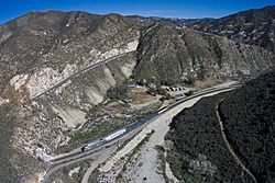
Soledad Canyon is a busy place for transportation. It has the Soledad Canyon Road, which is one of the longest streets in Santa Clarita. Also, State Route 14, known as the Antelope Valley Freeway, runs through it. The Metrolink Antelope Valley Line train also travels through the canyon. People riding the Antelope Valley Line get to see a lot of the Santa Clara River. The Vincent Grade/Acton station serves the communities located inside the canyon.
Future High-Speed Rail Plans
Soledad Canyon was chosen as the best route for a planned California High-Speed Rail line. This line will connect Burbank Airport to Palmdale. Maps for the project show that five tunnels will need to be dug through the mountainsides. The train line will also cross State Route 14 on a raised structure. Trains might start running on this line in 2033.
The Pacific Crest Trail
The Pacific Crest Trail also goes through the western parts of Soledad Canyon. This famous hiking trail goes from north to south. Hikers come down the southern slopes of the Sierra Pelona Mountains. The trail then passes through Agua Dulce and Vasquez Rocks. After that, it winds up a mountain ridge. Finally, it goes down into the main part of Soledad Canyon. It passes under the Antelope Valley Line train tracks and crosses the Santa Clara River. From there, the trail continues up into the San Gabriel Mountains.
 | Percy Lavon Julian |
 | Katherine Johnson |
 | George Washington Carver |
 | Annie Easley |

