San Gabriel Peak facts for kids
Quick facts for kids San Gabriel Peak |
|
|---|---|

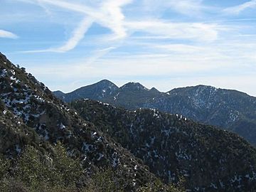
San Gabriel Peak, seen from the north.
|
|
| Highest point | |
| Elevation | 6,164 ft (1,879 m) NAVD 88 |
| Prominence | 1,561 ft (476 m) |
| Listing | Hundred Peaks Section |
| Naming | |
| English translation | Saint Gabriel |
| Language of name | Spanish |
| Geography | |
| Location | Los Angeles County California, U.S. |
| Parent range | San Gabriel Mountains |
| Topo map | USGS Mount Wilson |
| Climbing | |
| First ascent | Wheeler Survey, 1875 |
| Easiest route | Hike, class 1 |
San Gabriel Peak is a mountain peak located in the San Gabriel Mountains in California, a state in the U.S.. The United States Geological Survey officially named it in 1894. You can find this peak within the beautiful Angeles National Forest. Interestingly, it was first called The Commodore, named after a person known as Commodore Perry Switzer.
What's in a Name?
The name San Gabriel Peak comes from a very old mission called the Misión del Santo Arcangel San Gabriel de los Temblores. This mission's name also inspired other nearby places. For example, the San Gabriel River and San Gabriel Canyon got their names from it. Even the entire mountain range and the wide San Gabriel Valley are named after this historic mission.
Mountain Features
The southern side of San Gabriel Peak is very steep. It drops about 1,000 feet into a bowl-shaped area. This area is at the top of Eaton Canyon. This makes it one of the steepest and longest slopes in the western part of the San Gabriel Mountains. It's a truly impressive sight!
See also
 In Spanish: Pico de San Gabriel para niños
 | Tommie Smith |
 | Simone Manuel |
 | Shani Davis |
 | Simone Biles |
 | Alice Coachman |

