Gran Desierto de Altar facts for kids
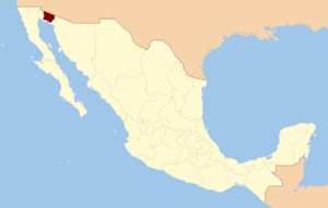
The Gran Desierto de Altar is a huge desert area in northwest Mexico, specifically in the state of Sonora. It's a major part of the larger Sonoran Desert. This desert is special because it has the only active "erg" (a large, sandy desert with dunes) in North America.
The Gran Desierto stretches for more than 100 kilometers (62 miles) from east to west and over 50 kilometers (31 miles) from north to south, along the northern edge of the Gulf of California. It's the biggest continuous wild area within the Sonoran Desert.
The eastern part of this desert includes the Pinacate Peaks, which are volcanic mountains. This whole area, including the desert and the volcanoes, is protected as the El Pinacate y Gran Desierto de Altar Biosphere Reserve. It's also recognized as a UNESCO World Heritage Site, meaning it's very important globally.
Contents
Geography of the Gran Desierto

The Gran Desierto covers about 5,700 square kilometers (2,200 square miles). Most of it is in Mexico, but its northern edges reach into Arizona, United States, touching places like Organ Pipe Cactus National Monument.
This desert is mostly covered by sand, with dunes that can be very thick. The huge amount of sand here, about 60 cubic kilometers (14 cubic miles), came from the Colorado River. Long ago, about 120,000 years ago, the Colorado River flowed through this area and left behind all this sand. Over time, as the Gulf of California opened up, the river's path changed.
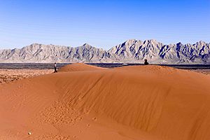
The eastern side of the Gran Desierto meets the Sierra Pinacate mountains, which are made of old volcanoes. The wind has blown sand onto the western slopes of these mountains, marking the desert's edge. To the north, the sand thins out near other mountains along the Arizona-Sonora border. The southern edge of the desert is the northern shore of the Gulf of California.
A very famous fault line, the southernmost part of the San Andreas Fault, runs through this area. It goes under some large granite hills called "inselbergs." One of these is the Sierra del Rosario mountains, which are surrounded by sand. Another smaller hill, the Sierra Enterrada, is almost completely buried by the sand.
Amazing Sand Dunes
The Gran Desierto is famous for its incredible star dunes. Many of these dunes are taller than 100 meters (328 feet)! More than two-thirds of the desert is covered by flat sand areas and long sand streaks. The rest of the area has two main types of dunes: star dunes in the west and crescent-shaped dunes in the east. Some of the larger crescent dunes even have changing crests, which is a feature also seen in star dunes.
Plants of the Desert (Flora)
The plants in the Gran Desierto are typical of the lower Sonoran Desert. The types and amounts of plants change depending on where you are. In many parts of the southern and eastern desert, you can find a good amount of small shrubs and herbs. These include plants like bursage (Ambrosia dumosa) and longleaf jointfir (Ephedra trifurca). Creosote bush grows where the sand is thinner.
On the northern side of the desert, especially in dry riverbeds called arroyos, you might see communities of palo verde, acacia, and ocotillo trees. About 15% of the star dune areas have plants, and about 10% of the crescent dune areas have plants. This is actually quite a lot for an active sand desert!
Scientists have studied old nests built by pack rats to learn about plants from the past. These studies show that the Gran Desierto has been a safe home for desert plants for a very long time, at least since the last Ice Age. It even protected plants from the Mojave Desert during cooler, wetter times. For example, a very old pack rat nest found in the Tinajas Altas Mountains showed that juniper and Joshua trees lived there more than 43,000 years ago, alongside plants that grow there today. This tells us that the Gran Desierto has been a desert for a very long time.
Animals of the Desert (Fauna)
Desert Climate
The Gran Desierto has a very warm to hot arid climate (meaning it's very dry). Most of the rain falls between September and December. For example, Puerto Peñasco, a town on the desert's southeastern edge, gets about 73 millimeters (2.9 inches) of rain each year. As you go north towards Yuma, Arizona, the rainfall decreases to about 62 millimeters (2.4 inches) per year.
In the middle of summer, temperatures often go above 45 degrees Celsius (113 degrees Fahrenheit). In winter, it's rarely colder than 10 degrees Celsius (50 degrees Fahrenheit). Winds in the summer usually come from the south, while in winter, they mostly blow from the north or northeast.
Climate in the Past
During the last ice age (called the Wisconsin glaciation), much of the southwestern United States was wetter. However, it seems the Gran Desierto might not have been as wet. Evidence suggests that the climate here has been getting drier for the past 150,000 years. The very dry conditions we see today have been in place for at least 43,000 years.
How the Desert Formed (Geology)
The story of the Gran Desierto is closely tied to how the Gulf of California opened up and how the Colorado River changed its course. The land has shifted, and sand formations have been created, changed, or even destroyed and rebuilt over time.
The sand sheets and dunes of the Gran Desierto sit on top of old river deposits from the Colorado River during the Pleistocene era. The lower Colorado River started flowing into the Gulf of California about 1.2 million years ago. This gives us an idea of how old the Gran Desierto's sand might be. Studies of sand and silt found beneath the Mesa Arenosa suggest they are between 700,000 and 120,000 years old.
Fossils of animals like ancient horses (Equus), elephant-like creatures (Gomphotherium), and bison have been found in these river deposits. These fossils date back to between 0.5 and 1.8 million years ago. Even a fossil of a giant anteater (Myrmecophaga tridactyla) was found! This anteater fossil was found with mammoths, sloths, and boa constrictors. This suggests that the Colorado River delta, more than 120,000 years ago, was much warmer and wetter than it is today.
Some studies suggest that wind-blown sand activity might have started as early as 700,000 years ago, based on dated rock layers on the Pinacate volcanoes.
Scientists believe that during the late Pleistocene, the Colorado River was a very strong river flowing through what is now the massive western star dune area. At that time, the seashore was about 45 kilometers (28 miles) south of where it is now. The river deposited lots of gravel and sand. As the Gulf of California continued to open and the coast lifted, the river channel moved west, leaving behind its old deposits. The river sediments under the Gran Desierto could be as deep as 6,000 meters (3.7 miles).
Before dams were built on the Colorado River, it carried huge amounts of sediment. A single flood could deposit 100,000,000 cubic meters (3.5 billion cubic feet) of sand on the delta. Events like this, even if rare, could fill up the Gran Desierto with sand in just a few thousand years.
Moving Earth (Tectonics)
The Gran Desierto is next to a fast-sinking area called the Salton Trough. This trough is an extension of the Gulf of California, which itself was formed by the Earth's crust pulling apart along the East Pacific Rise and the San Andreas fault system. This pulling apart and shifting of the Earth's plates continues today. The center of the nearby Salton Trough is more than 70 meters (230 feet) below sea level! It's only protected from the ocean by the natural barrier of the Colorado River Delta.
This ongoing movement of the Earth's plates still changes the Gran Desierto. The southernmost part of the San Andreas fault system, called the Cerro Prieto Fault, goes right through the area. The ground here can shift by as much as 60 millimeters (2.4 inches) each year.
Since 1900, there have been several strong earthquakes in the desert, including one at magnitude 6.3 and two at magnitude 7.1. Most of these earthquakes happen deep underground, where the river deposits meet the solid rock beneath. Some areas, like the Mesa Arenosa along the coast, are still slowly lifting up.
Underwater Features
The way the Colorado River Delta and the Gran Desierto formed also extends underwater into the Gulf of California. Studies of the seafloor show three old river channels. One starts at the current Colorado delta, another from an old delta area, and a third near Puerto Peñasco. Scientists have also found two long, deep depressions, each about 40 kilometers (25 miles) long, where these old river channels end, about 180 meters (590 feet) below sea level. These underwater valleys were also formed by rivers long ago.
See also
 In Spanish: Gran desierto de Altar para niños
- El Pinacate y Gran Desierto de Altar Biosphere Reserve
- Sonoran Desert
- Colorado Desert
- Lechuguilla Desert
- Tule Desert
- Yuma Desert
- Chihuahuan Desert
 | James Van Der Zee |
 | Alma Thomas |
 | Ellis Wilson |
 | Margaret Taylor-Burroughs |


