Tinajas Altas Mountains facts for kids
Quick facts for kids Tinajas Altas Mountains |
|
|---|---|

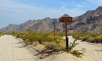
Sign along El Camino Del Diablo in Barry M. Goldwater Air Force Range, near Wellton, Arizona, at spur road to Tinajas Altas.
|
|
| Highest point | |
| Peak | Unnamed (32°16′26″N 114°02′48″W / 32.27389°N 114.04667°W) |
| Elevation | 843 m (2,766 ft) |
| Dimensions | |
| Length | 35 km (22 mi) |
| Width | 6.4 km (4.0 mi) |
| Geography | |
| Countries | United States and Mexico |
| Settlement | Fortuna Foothills, Arizona |
| Range coordinates | 32°17′00″N 114°03′00″W / 32.2833333°N 114.05°W |
| Geology | |
| Type of rock | granite–(light-colored) |
The Tinajas Altas Mountains are a very dry mountain range. They stretch from northwest to southeast in southern Yuma County, Arizona. These mountains are about 35 miles (56 km) southeast of Yuma, Arizona.
A small part of the range, about one mile long, reaches into the Mexican state of Sonora. This area is on the edge of the Gran Desierto de Altar, a large desert. The entire range is about 22 miles (35 km) long and 4 miles (6.4 km) wide. The highest point in the range does not have a name. It stands 2,766 feet (843 meters) above sea level. Most of the mountains are inside the Barry M. Goldwater Air Force Range. This area is also the traditional home of the Hia C-eḍ Oʼodham people, who call the mountains Uʼuva:k or Uʼuv Oopad.
Contents
Mountain Makeup and Location
How the Mountains Formed
The Tinajas Altas Mountains are connected to the Gila Mountains. They are both formed by a process called block faulting. This is when large blocks of the Earth's crust move up or down along cracks called faults. Until the mid-1900s, people thought the Tinajas Altas Mountains were part of the Gila Mountains.
Separation and Features
The two mountain ranges are separated by a place called Cipriano Pass. This pass is also known as "Smugglers Pass." Near the pass is a dark, volcanic rock formation called Raven Butte. It stands out against the lighter-colored granite rocks of the Tinajas Altas Mountains.
The Famous Waterholes
The name "Tinajas Altas" means "High Tanks" in Spanish. This name comes from a series of natural waterholes found on the eastern side of the mountains. These waterholes are about four miles north of the border with Mexico. For many years, these waterholes were the only reliable source of water for miles around.
Native Americans, especially the Hia C-eḍ O'odham, used these waterholes as an important camping spot. They were vital before European settlers arrived in the area.
Desert Environment
The Tinajas Altas Mountains are located in the Lower Colorado River Valley part of the Sonoran Desert. This area is sometimes called the Colorado Desert. It covers parts of California, Arizona, Sonora (Mexico), and Baja California (Mexico). This desert region gets very little rain. The area around the Tinajas Altas Mountains receives only about three inches (7.6 cm) of rainfall each year.
Neighboring Ranges
Maps from Mexico and the United States Geological Survey (USGS) have different names for a small mountain range southeast of the Tinajas Altas Mountains. In the United States, it's called the Sierra de la Lechuguilla. In Mexico, it's called the Sierra Tinajas Altas. This might make you think it's a longer part of the Tinajas Altas Mountains. However, these two ranges are not connected on the surface. They run side-by-side, but are separate.
Nearby Towns
The closest town to the Tinajas Altas Mountains is Fortuna Foothills. This community is located east of the Yuma Valley, next to the Gila Mountains.
Plants and Animals
The Tinajas Altas Mountains are home to many different types of flora (plants) and fauna (animals). One interesting plant found here is the elephant tree (Bursera microphylla). This tree has a unique, twisted shape with many branches.
See also
 In Spanish: Sierra de las Tinajas Altas para niños
 | William L. Dawson |
 | W. E. B. Du Bois |
 | Harry Belafonte |


