
El Camino del Diablo facts for kids
Quick facts for kids |
|
|
El Camino del Diablo
|
|

El Camino del Diablo in the Barry M. Goldwater Air Force Range, near Wellton, Arizona
|
|

Location in Arizona
|
|
| Nearest city | Lukeville, Arizona |
|---|---|
| Built | 1699 |
| NRHP reference No. | 78000560 |
| Added to NRHP | December 1, 1978 |
El Camino del Diablo (which means "The Devil's Highway" in Spanish) is a very old road. It stretches for about 250 miles (400 km) through a very dry and remote part of the Sonoran Desert in Arizona.
People have used this path for at least 1,000 years. It probably started as small footpaths used by Native Americans who lived in the desert. Later, from the 1500s to the 1800s, it was used by explorers, missionaries, and people looking for gold.
The trail's name, "The Devil's Highway," and another old name, "Road of the Dead Man," tell you how tough and dangerous it was to travel. Many people faced extreme heat and thirst here. Because of its long history, El Camino del Diablo was added to the National Register of Historic Places in 1978.
Contents
Where the Old Trail Went
.JPG)
The original El Camino del Diablo started in a town called Caborca in Sonora, Mexico. From there, it went through Sonoyta, then past a place called Quitobaquito Springs.
The path continued through rocky areas and wide, flat deserts like the Tule Desert. A very important stop was at Tinajas Altas. This name means "high tanks" in Spanish. Here, natural pools of rainwater collected in the rocks.
After Tinajas Altas, the trail crossed some mountains and then headed northwest. It finally reached the Colorado River at a place called Yuma Crossing. From Yuma, travelers could continue to the Spanish colonies of California.
Over time, this trail was also known by other names, like the Sonora Trail or the Old Yuma Trail.
A Journey Through Time
El Camino del Diablo began as paths used by Native Americans over a thousand years ago. In 1540, a Spanish captain named Melchor Díaz traveled near here with Native American guides. He was exploring the area.
The first Europeans known to travel the entire trail were a group led by a Jesuit priest named Eusebio Kino in 1699. They had Native American guides who knew where to find water. The trail was a shorter way to get to California than sailing all the way around Baja California. It also helped them avoid some unfriendly Native American tribes.
However, in 1781, a Native American group called the Quechan people rebelled at Yuma Crossing. This made it very hard for travelers to use the trail. El Camino del Diablo was not used much again until 1848-1849. This was when the California Gold Rush started, and many people, especially from Sonora, Mexico, wanted to reach the gold fields in California.
Later, teams from the United States and Mexican Boundary Survey used the trail. They were mapping the land that the U.S. bought in 1853, known as the Gadsden Purchase. More miners from Sonora used the trail in the 1860s when gold was found along the Colorado River.
The Dangers of the Trail
Traveling on El Camino del Diablo was extremely dangerous. Many people were not used to the harsh desert conditions. They often died from thirst and heat exhaustion. One traveler noted that there were "frequent graves and bleaching skulls of animals" along the way. These were sad reminders of those who didn't make it.
The toughest part of the trail was a 130-mile (209 km) stretch from Sonoyta, Mexico, to what is now Yuma, Arizona. It's estimated that between 400 and 2,000 travelers lost their lives on this trail. The main causes were dehydration (not enough water) and heat stroke.
In the summer, temperatures can reach 120°F (49°C). People needed about 2 gallons (7.6 liters) of water every day just to survive. Most of the graves are found along the last 30 miles (48 km) of the trail to Yuma. For example, there are 65 graves near Tinajas Altas.
Decline and Recognition
The use of El Camino del Diablo dropped sharply after the Southern Pacific Railroad reached Yuma in 1870. The railroad offered a much safer and faster way to travel.
While some gold seekers and visitors still went to the area, the trail never became a major travel route again. Mapmakers and survey teams sometimes used it. They often found many remains of both people and animals.
In 1978, El Camino del Diablo was recognized for its important history and listed on the National Register of Historic Places. Today, visitors can still travel parts of it. It runs through the Cabeza Prieta National Wildlife Refuge, which was created in 1939 to protect desert animals. Much of the original trail remains almost exactly as it was long ago.
Tinajas Altas: The High Tanks

Tinajas Altas means "high tanks" in Spanish. It was a very important stop on the trail. Here, there are nine natural, cup-shaped pools. They are stacked one above the other on a steep granite rock. These pools fill up only when it rains.
When they are full, these tinajas can hold a lot of water, up to 20,000 gallons (75,700 liters). But because there isn't much rain and the air is very dry, one or more pools were often empty. In the past, some travelers died after finding the pools dry.
During a U.S. Boundary Survey in the 1890s, the survey team heard a sad story. Three dead gold seekers were found just above the first empty tank. Their fingers were raw from climbing the rock to the second tank, which held water. They had died just yards away from saving themselves.
El Camino del Diablo Today

Today, El Camino del Diablo is still a dirt road. It's only suitable for four-wheel drive vehicles that sit high off the ground. Travelers must carry extra water and emergency gear. There are no emergency or tow services available. People who use the trail do so at their own risk.
South of the Mexico–United States border, the original parts of the Camino del Diablo in Mexico have mostly disappeared. The Mexican government has built a paved highway, Mexican Federal Highway 2, which runs near the border for about 120 miles (193 km).
The current route in the U.S. starts southwest of Ajo, Arizona. It passes through the Organ Pipe Cactus National Monument and the Cabeza Prieta National Wildlife Refuge. The road then goes west, passing by different mountains and sand dunes. It goes through the Tule Desert and reaches Tule Well.
At Tinajas Altas, the road splits. One shorter route goes north through the Barry M. Goldwater Air Force Range to Wellton, Arizona. Another, longer route follows the original path more closely. This route continues northwest, passing by an old mine, before reaching Fortuna Foothills, Arizona.
The trail follows the Mexico–United States border very closely for most of its length. To drive the entire trail, you need a permit from the Cabeza Prieta National Wildlife Refuge office in Ajo.
Images for kids
-
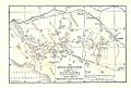
1908 map of the Arizona/Mexico border, showing the Camino del Diablo.

