Coyote Mountains facts for kids
Quick facts for kids Coyote Mountains |
|
|---|---|
 |
|
| Highest point | |
| Peak | Carrizo Mountain |
| Elevation | 734 m (2,408 ft) |
| Geography | |
| Country | United States |
| State | California |
| District | San Diego County and Imperial County |
| Range coordinates | 32°48′41.206″N 116°4′24.049″W / 32.81144611°N 116.07334694°W |
| Topo map | USGS Carrizo Mountain |
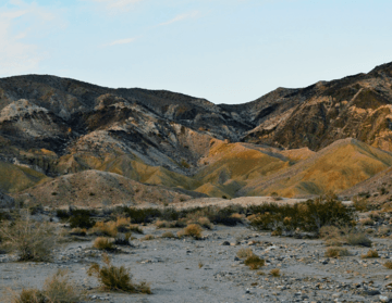
The Coyote Mountains are a small mountain range. You can find them in San Diego and Imperial Counties. These counties are in southern California.
The mountains are about 2 miles wide. They stretch for about 12 miles from east-southeast to west-northwest. The highest point is Carrizo Mountain. It stands at about 2,408 feet (734 meters) tall. Mine Peak is at the other end, reaching about 1,850 feet.
The Coyote Mountains are near other interesting places. To the southeast are the Jacumba Mountains. To the north are the Carrizo Badlands. Part of the range is inside the Anza-Borrego Desert State Park. The eastern part is in the Carrizo Naval Gunnery Range.
Contents
Exploring the Coyote Mountains
The Coyote Mountains were once covered by the ancient Sea of Cortez. Earthquakes later pushed these old sand dunes upwards. Much of the ground is still loose dirt. You can also find sandstone and some quartz rocks.
A dirt road leads to the mountains. It starts off State Highway 2 (S2). This highway is also known as the Imperial Highway. It's not far from the desert town of Ocotillo.
What to Expect When Visiting
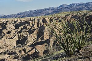
There are no marked trails in the Coyote Mountains. Walking can be tricky because of the loose sand and dirt. Most slopes don't have much plant life. But you might see mesquite trees and ocotillo plants. At lower elevations, you can find coastal cholla cactus.
Local animals include jackrabbits and sparrows.
Wind Caves and Fossils
Some ancient sand dunes have turned into rock. Over time, winds have carved out "wind caves" in these rocks. You can also find marine fossils here. These include old sand dollars and snails. Remember, it is against the law to take any fossils from the area.
In 1994, the United States Congress set aside a large area. This area is 18,631 acres (75 square kilometers). It became the Coyote Mountains Wilderness. This means it's a special protected natural area. It is managed by the Bureau of Land Management.
How the Coyote Mountains Formed
The Coyote Mountains are made of very old rocks. These are called metamorphic basement rocks. Younger volcanic and sedimentary rocks sit on top of them. The mountain peaks are mostly made of these old rocks. They include marble, schist, and gneiss.
These rocks were lifted up by earthquake activity. This happened along a major crack in the Earth's crust called the Elsinore Fault Zone.
Ancient Volcanoes
Millions of years ago, about 22 to 14 million years ago, volcanoes were active here. They created different kinds of volcanic rocks. These include basalt flows and andesite. There are also rocks made from volcanic ash and debris. This rock layer is known as the Alverson Formation.
You can see these volcanic rocks best in the Painted Gorge area. This area has many colorful volcanic rocks. They make the landscape look like a beautiful painting.
When the Sea Covered the Land
Later, about 6.3 to 4.3 million years ago, the land sank. This allowed the sea to flow in. This event is called a marine incursion. It created a shallow inland sea. This sea covered much of the Salton Trough region.
During this time, the Imperial Formation was created. This formation is made of sandstones and conglomerates. These rocks contain many fossils of sea creatures. These include corals and other shallow marine animals. These rocks were laid down directly on top of the older volcanic and metamorphic rocks.
The Colorado River's Influence
The ancient Gulf of California also brought in the Colorado River. This river started building a huge delta. This delta quickly grew southwards. Between 5 and 4.2 million years ago, the river deposited thick layers of mudstone and sandstone. This formed the Deguynos Formation. This formation shows how the Colorado River delta changed the area.
As the river continued to flow, the area changed from a sea delta to a river system. Between 4.2 and 2.8 million years ago, non-marine sediments were deposited. These are seen in the Arroyo Diablo Formation. It has fine, light pink sandstones and reddish-gray mudstones.
More local sediments built up until about 1 million years ago. This formed the Hueso Formation. Eventually, the land stopped sinking. The build-up of sediments stopped.
Recent Uplift and Erosion
The Coyote Mountains are in a very active area. The Salton Trough is a basin that is pulling apart. This is due to the actions of the San Andreas Fault and the East Pacific Rise. Other major faults like the Elsinore Fault Zone are also active.
In the last 1.2 million years, the Elsinore Fault Zone has rapidly lifted the Coyote Mountains. This has exposed the old metamorphic, volcanic, and sedimentary rocks. Imagine, marine fossils that formed in a shallow sea are now over 2,000 feet above sea level!
This fast uplift has also caused a lot of erosion. Wind and rain carve deep canyons into the exposed rocks. They carry loose material downhill. Gravels from this erosion form terraces. These terraces are from the Pleistocene and Holocene (our current time) periods.
The sediments north of the Coyote Mountains are also shaped by this uplift. The ongoing movement of the Elsinore fault continues to change the landscape. This creates a complex system of faults. These processes are still happening today.
 | Janet Taylor Pickett |
 | Synthia Saint James |
 | Howardena Pindell |
 | Faith Ringgold |


