Westmorland, California facts for kids
Quick facts for kids
City of Westmorland
|
||
|---|---|---|

City Hall of Westmorland
|
||
|
||
| Motto(s):
"Today's Roadrunners Tomorrow's Leaders"
|
||

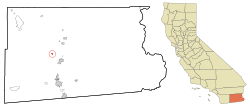
Location in Imperial County and the state of California
|
||
| Country | United States | |
| State | California | |
| County | Imperial | |
| Incorporated | June 30, 1934 | |
| Area | ||
| • Total | 0.59 sq mi (1.53 km2) | |
| • Land | 0.59 sq mi (1.53 km2) | |
| • Water | 0.00 sq mi (0.00 km2) 0% | |
| Elevation | -164 ft (−50.0 m) | |
| Population
(2020)
|
||
| • Total | 2,014 | |
| • Density | 3,820.34/sq mi (1,474.85/km2) | |
| Time zone | UTC-8 (Pacific (PST)) | |
| • Summer (DST) | UTC-7 (PDT) | |
| ZIP code |
92281
|
|
| Area codes | 442/760 | |
| FIPS code | 06-84606 | |
| GNIS feature IDs | 1652812, 2412239 | |
Westmorland is a small city in Imperial County, California. It's about 8.5 miles (13.7 km) southwest of Calipatria. In 2020, about 2,014 people lived there. Westmorland is part of the El Centro Metropolitan Area. The current mayor of Westmorland is Ana Beltran.
The city is located on State Route 86. This highway was improved to make travel safer. It connects Westmorland to nearby cities like Brawley and El Centro. It also links to Mexicali, in Baja California, Mexico.
Westmorland's post office first opened in 1909. It was originally called Westmoreland. The name was changed to Westmorland in 1936. The city officially became a city (incorporated) in 1934. For a long time, Westmorland faced challenges with its economy.
Contents
City Location and Landscape
Westmorland is a small city, covering about 0.4 square miles (1.0 km2) of land. It is unique because it sits below sea level. The area around Westmorland has several active fault lines. This means the city has experienced many earthquakes over the years. Some notable tremors happened in 1907, 1916, 1925, 1940, 1948, 1965, and 1979. A strong earthquake in 1987 caused serious damage in Westmorland and the wider Imperial Valley.
City Population and People
| Historical population | |||
|---|---|---|---|
| Census | Pop. | %± | |
| 1940 | 1,010 | — | |
| 1950 | 1,213 | 20.1% | |
| 1960 | 1,404 | 15.7% | |
| 1970 | 1,175 | −16.3% | |
| 1980 | 1,590 | 35.3% | |
| 1990 | 1,380 | −13.2% | |
| 2000 | 2,131 | 54.4% | |
| 2010 | 2,225 | 4.4% | |
| 2020 | 2,014 | −9.5% | |
| U.S. Decennial Census | |||
Population in 2010
In 2010, Westmorland had a population of 2,225 people. The city was quite diverse. About 46.7% of residents were White, and 87.1% were of Hispanic or Latino background.
Most people lived in family homes. About 53.2% of households had children under 18. The average household had about 3.53 people. The average family size was about 3.82 people.
The population included many young people. About 34.4% of residents were under 18 years old. The median age in Westmorland was 29.2 years.
Population in 2000
In 2000, there were 2,131 people living in Westmorland. The city's population was also very diverse then. About 82.2% of the people were of Hispanic or Latino background.
Many households had children. About 47.7% of homes had kids under 18. The average household size was 3.4 people, and the average family size was 3.9 people.
The median age was 29 years. This means half the people were younger than 29, and half were older.
Local Schools
Children in Westmorland attend schools within the Westmorland Elementary School District for grades K-8. After elementary school, high school students go to schools in the neighboring Brawley Union High School District.
City Services
Westmorland has its own public works department. This department is in charge of providing water and managing the wastewater system for the city's residents.
See also
 In Spanish: Westmorland (California) para niños
 | Georgia Louise Harris Brown |
 | Julian Abele |
 | Norma Merrick Sklarek |
 | William Sidney Pittman |


