
Bombay Beach, California facts for kids
Quick facts for kids
Bombay Beach
|
|
|---|---|

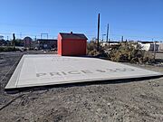
Sign for Bombay Beach
|
|

Location in Imperial County and the state of California
|
|

Bombay Beach, California
Location in the United States
|
|
| Country | United States |
| State | California |
| County | Imperial |
| Area | |
| • Total | 0.66 sq mi (1.72 km2) |
| • Land | 0.66 sq mi (1.72 km2) |
| • Water | 0.00 sq mi (0.00 km2) 0% |
| Elevation | -223 ft (−68 m) |
| Population
(2020)
|
|
| • Total | 231 |
| • Density | 347.89/sq mi (134.37/km2) |
| Time zone | UTC−8 (Pacific) |
| • Summer (DST) | UTC−7 (PDT) |
| ZIP code |
92257
|
| Area codes | 442/760 |
| FIPS code | 06-07372 |
| GNIS feature IDs | 1667823, 2407878 |
Bombay Beach is a small community in Imperial County, California, United States. It's a special kind of community called a census-designated place (CDP). This means it's a place the government counts for population, but it's not officially a city or town.
Bombay Beach is located right on the edge of the Salton Sea. It's famous for being the lowest community in the United States, sitting 223 feet (68 m) below sea level! In 2020, about 231 people lived there.
This unique spot was once a popular vacation destination. People loved coming here for beach fun until the 1980s. That's when the Salton Sea started to change, becoming too salty. This hurt the lake's plants and animals. Many businesses and people left, making Bombay Beach seem like a ghost town.
But guess what? By 2018, things started to change! Artists, thinkers, and creative people began moving in. They saw beauty in the abandoned buildings and the town's history. Now, Bombay Beach is known as a cool, artistic place. It even hosts an annual art festival called the Bombay Beach Biennale.
Contents
History of Bombay Beach
A Popular Getaway in the Past
Back in the 1950s, Bombay Beach was a super popular place for vacations. Imagine celebrities like Frank Sinatra and the Beach Boys visiting! People enjoyed luxury resorts along the Salton Sea. They loved fishing, boating, and water skiing. Half a million tourists came every year, which was almost as many as visited Yosemite National Park.
The Decline of the Salton Sea
The fun times started to fade in the 1970s. Water flowing into the Salton Sea carried salty chemicals. Scientists warned that the lake would soon be too salty for fish to live. By the early 1980s, this sadly came true.
Many people living around the Salton Sea, including those in Bombay Beach, started to leave. The smell of dying fish was strong. People worried about their health. Also, the lake's water levels kept changing, causing floods and then drying up parts of the shore.
Life in a "Living Ghost Town"
Today, many of the people who still live in Bombay Beach are either too poor to move or they love the area's history too much to leave. A report in 2019 said that over 97% of the fish that were once in the Salton Sea were gone.
Getting around town is often done by golf carts. The nearest gas station is 20 miles (32 km) away! There are only two small stores and one bar/restaurant called the Ski Inn. The closest hospital is over 45 minutes away.
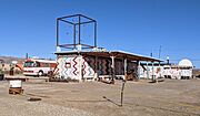
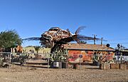
One cool art spot is the "Bombay Beach Drive-In." It's an art display made of old, abandoned cars. Many buildings in town are empty and covered in graffiti. This "living ghost town" feel attracts lots of photographers, filmmakers, and tourists.
A New Chapter for Bombay Beach
In 2018, people started moving back to Bombay Beach. House prices even went up! Some small houses were selling for thousands of dollars. The community has been holding the Bombay Beach Biennale every spring since 2016. This festival invites artists, writers, and filmmakers to create and share their work. The 2020 festival was postponed because of the COVID-19 pandemic.
Most residents in Bombay Beach today are older people. They live in mobile homes and unique, sometimes very creative, small houses.
Geography of Bombay Beach

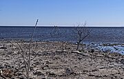
Bombay Beach is located in the Sonoran Desert in Southern California. It sits on the east side of the Salton Sea. Like other towns along the lake, Bombay Beach has dealt with the water levels changing a lot. This has made the lake smaller and saltier.
In the 1970s, a protective wall, called a berm, was built to save the western part of the town. But some areas beyond this wall were either flooded or buried in mud. Bombay Beach is also near the southern end of the San Andreas Fault, a very famous earthquake fault line.
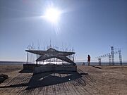
Art in Bombay Beach
Bombay Beach is now famous for its many unique art pieces and installations. You can find them all around the town and along the beach.
-
The ZigZag House
-
“The Water’s Fine, It’s Just Salty” by Ssippi.
-
Art pieces
-
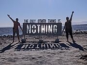
The Only Other Thing by Michael Birnberg
-
“Park Place” by David Corcoran and Tao Ruspoli
-
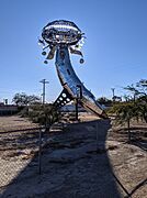
“Lodestar” by Randy Polumbo.
-
Flying fish


Population Changes
| Historical population | |||
|---|---|---|---|
| Census | Pop. | %± | |
| 1990 | 929 | — | |
| 2000 | 366 | −60.6% | |
| 2010 | 295 | −19.4% | |
| 2020 | 231 | −21.7% | |
| U.S. Decennial Census 1850–1870 1880-1890 1900 1910 1920 1930 1940 1950 1960 1970 1980 1990 2000 2010 |
|||
The population of Bombay Beach has changed quite a bit over the years.
- In 1990, there were 929 people.
- By 2000, the population dropped to 366.
- In 2010, it was 295 people.
- And in 2020, the population was 231.
This shows a decrease in population as the Salton Sea changed. However, as mentioned, artists and others have started to move back in recent years.
See also
 In Spanish: Bombay Beach para niños
