Coachella, California facts for kids
Quick facts for kids
Coachella, California
|
|||
|---|---|---|---|

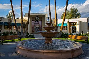
Coachella City Hall
|
|||
|
|||
| Nicknames:
Coachello, La Coachelita and Cochela
|
|||

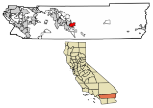
Location of Coachella in Riverside County, California
|
|||
| Country | United States | ||
| State | California | ||
| County | Riverside | ||
| Native American Reservation (partial) | Twenty-Nine Palms Band of Mission Indians & Cabazon Band of Mission Indians | ||
| Incorporated | December 13, 1946 | ||
| Government | |||
| • Type | Council-Manager | ||
| Area | |||
| • Total | 30.08 sq mi (77.90 km2) | ||
| • Land | 30.08 sq mi (77.90 km2) | ||
| • Water | 0.00 sq mi (0.00 km2) 0% | ||
| Elevation | -69 ft (-21 m) | ||
| Population
(2020)
|
|||
| • Total | 41,941 | ||
| • Density | 1,394.41/sq mi (538.39/km2) | ||
| Time zone | UTC−8 (PST) | ||
| • Summer (DST) | UTC−7 (PDT) | ||
| ZIP code |
92236
|
||
| Area codes | 442/760 | ||
| FIPS code | 06-14260 | ||
| GNIS feature IDs | 1652686, 2409493 | ||
Coachella is a city in Riverside County, California, United States. It is in the eastern part of the Coachella Valley, which is in the Colorado Desert in Southern California. Coachella started as a railroad town. Today, it is a major center for farming and shipping goods across Southern California and the Western United States.
Coachella is one of California's fastest-growing cities. In 1946, when it became a city, only 1,000 people lived there. By 2020, the population had grown to 41,941. The city uses both English and Spanish officially. About 90% of the people speak Spanish.
Contents
History of Coachella
The city was first called Woodspur in 1876. This was when the Southern Pacific Railroad built a rail siding (a short track for trains) there. In the 1880s, the local Cahuilla tribe sold their land to the railroads. They moved to new lands east of the town.
In the 1890s, many traqueros (Mexican railroad workers) settled near the tracks. In 1901, the people of Woodspur voted to change the name of their community to "Coachella."
The exact origin of the name Coachella is not fully clear. Some local people believe it came from a Spanish word, conchilla. This word means "small white snail shells." These shells are found in the valley's sandy soil. They are left over from a lake that dried up more than 3,000 years ago.
Coachella started as a small area of about 2.5 square miles (6.5 km2). It was laid out on the desert floor. Coachella officially became a city in 1946.
In the 1950s, Coachella began to grow. It expanded to about 32 square miles (83 km2). This area included large farms that grew crops all year. They grew fruits like citrus (lemons, oranges, grapefruit) and date palms.
By 1980, Coachella's population had reached at least 10,000 people. Many people of Hispanic background lived in the city. This made Coachella a place for Chicano political action. The farms around Coachella were where the United Farm Workers union held strikes and protests. Their leader, César Chávez, visited in the 1960s and 1970s. In 2018, the main street in town, Harrison Street, was renamed after him.
In 1995, government officials made Coachella part of the Coachella Valley Enterprise Zone. This was done to help the economy and bring new businesses to the city.
In 2010, a Coca-Cola bottling factory opened in Coachella. This building was designed to be good for the environment. It was a helpful addition to the city's growing industries.
Geography of Coachella
Coachella covers about 28.95 square miles (75 km2) of land. There is no water within the city limits.
The city is about 68 feet (21 meters) below sea level. This is because the eastern part of the Coachella Valley is below sea level. The Salton Sea, a saltwater lake, is about 10 miles (16 km) south of Coachella. It is even lower, at 228 feet (69.5 meters) below sea level.
Climate
Coachella has a hot desert climate. This means it has clear skies and very little rain. It is very hot because of a high-pressure system that keeps the air dry. Even though it is close to Banning, California, Coachella gets only about a quarter of the rain that Banning does.
| Climate data for Coachella, California (1981–2010 normals) | |||||||||||||
|---|---|---|---|---|---|---|---|---|---|---|---|---|---|
| Month | Jan | Feb | Mar | Apr | May | Jun | Jul | Aug | Sep | Oct | Nov | Dec | Year |
| Record high °F (°C) | 95 (35) |
99 (37) |
104 (40) |
112 (44) |
116 (47) |
121 (49) |
123 (51) |
123 (51) |
121 (49) |
116 (47) |
102 (39) |
93 (34) |
123 (51) |
| Mean daily maximum °F (°C) | 70.7 (21.5) |
73.9 (23.3) |
80.5 (26.9) |
87.5 (30.8) |
95.6 (35.3) |
103.6 (39.8) |
108.1 (42.3) |
107.3 (41.8) |
101.7 (38.7) |
91.1 (32.8) |
78.4 (25.8) |
69.3 (20.7) |
89.0 (31.7) |
| Mean daily minimum °F (°C) | 45.5 (7.5) |
48.0 (8.9) |
52.2 (11.2) |
57.4 (14.1) |
64.4 (18.0) |
71.0 (21.7) |
77.6 (25.3) |
77.6 (25.3) |
71.7 (22.1) |
62.5 (16.9) |
51.8 (11.0) |
44.2 (6.8) |
60.3 (15.7) |
| Record low °F (°C) | 19 (−7) |
24 (−4) |
29 (−2) |
34 (1) |
36 (2) |
44 (7) |
54 (12) |
52 (11) |
46 (8) |
30 (−1) |
23 (−5) |
23 (−5) |
19 (−7) |
| Average precipitation inches (mm) | 1.15 (29) |
1.11 (28) |
0.53 (13) |
0.06 (1.5) |
0.02 (0.51) |
0.02 (0.51) |
0.13 (3.3) |
0.29 (7.4) |
0.23 (5.8) |
0.24 (6.1) |
0.32 (8.1) |
0.87 (22) |
4.97 (126) |
| Average precipitation days (≥ 0.01 in) | 3.1 | 3.2 | 1.6 | 0.6 | 0.2 | 0 | 0.6 | 0.9 | 0.8 | 0.7 | 0.8 | 1.9 | 14.4 |
| Source: NOAA | |||||||||||||
People of Coachella
Many people in Coachella are US citizens who were born and grew up there. A strong Mexican American culture has developed in the town over many generations. A large number of residents have family roots in the Mexican state of Sinaloa.
Most of the people living in Coachella are younger Latino families. About 90% of the population is of Hispanic origin. In the areas outside the city center, many people are farmworkers who move with the seasons. The city officially uses both English and Spanish. However, city council meetings are held in English. In the past, other groups lived in Coachella too. These included Arabs, Armenians, Filipinos, Italians, Japanese, and people from Southeast Asia and former Yugoslavia.
| Historical population | |||
|---|---|---|---|
| Census | Pop. | %± | |
| 1950 | 2,755 | — | |
| 1960 | 4,854 | 76.2% | |
| 1970 | 8,353 | 72.1% | |
| 1980 | 9,129 | 9.3% | |
| 1990 | 16,896 | 85.1% | |
| 2000 | 22,724 | 34.5% | |
| 2010 | 40,704 | 79.1% | |
| 2020 | 41,941 | 3.0% | |
| U.S. Decennial Census | |||
Population in 2010
In 2010, Coachella had a population of 40,704 people. The city was home to 8,998 households. About 73.6% of these households had children under 18. The average household had 4.52 people.
The population was quite young. About 38.8% of the people were under 18 years old. The average age in the city was 24.5 years.
Population in 2000
In 2000, there were 22,724 people living in Coachella. There were 4,807 households. About 65.9% of these households had children under 18. The average household had 4.72 people.
The population was also very young in 2000. About 40.8% of the people were under 18 years old. The average age was 23 years.
How Coachella Makes Money
Coachella's economy is strong in farming and shipping. It also has growing industries.
Main Employers
Here are some of the biggest employers in Coachella:
| # | Employer | Employees |
|---|---|---|
| 1 | Coachella Valley Unified School District | 530 |
| 2 | Spotlight 29 Casino | 496 |
| 3 | Ernie Ball | 380 |
| 4 | Augustine Casino | 314 |
| 5 | Armtec Defense | 236 |
| 6 | Valley Pride | 200 |
| 7 | Coachella Valley Water District | 194 |
| 8 | Teserra Outdoors | 156 |
| 9 | Cardenas Market | 118 |
| 10 | Reyes Coca-Cola Bottling | 103 |
Near Coachella, there are three casinos on Indian reservations. These are Fantasy Springs Resort and Casino, Spotlight 29 Casino, and Augustine Casino. Native American tribes own and run these casinos. These tribes have councils that help them be self-reliant. Coachella also has many people from Southwest Indian tribes like Apache, Hopi, Navajo, and Zuni.
Homes and Fun in Coachella
Since 2000, many new homes and apartment buildings have been built in Coachella. The city's population has more than doubled in just ten years.
Some areas have trailer parks, where many farmworkers live. Some of these parks have dirt roads and power problems. There are efforts to improve these areas. For example, dirt roads in 35 trailer parks are being paved. Money from a court case in 2000 helped build three housing projects for farmworkers.
Coachella has added more fun activities for its residents. The city has a recreation center and a Boys and Girls Club center. There is also a boxing club at Bagdouma Park. For adults, there are dance clubs and the Corona Yacht Club. Two new golf courses, Desert Lakes and the Vineyards, are popular with retirees and visitors.
Fun Things to Do and See
Three popular parties are held each year in Coachella:
- Cinco de Mayo (May 5)
- 16 de Septiembre Fiestas Patrias (Mexico's Independence from Spain)
- 12 de Diciembre (to celebrate the Virgin Mary, the patron saint of Mexico)
Other interesting places and events include:
- Coachella Valley Music and Arts Festival
- Coachella Valley Radio Control Club
- Shady Lane Mural
- The famous film director Frank Capra is buried in the Coachella Valley Cemetery.
Sports
The Coachella Football Club is a semi-professional American soccer team. It is based in Coachella. The team started in January 2024. They play in USL League Two, which is the fourth level of American soccer.
Schools in Coachella
Coachella is part of the Coachella Valley Unified School District. This district is based in Thermal, California.
The main high school is Coachella Valley High School, which has 2,900 students. There is also a newer high school called Desert Mirage High School. The city has three middle schools: Cahuilla Desert Academy, Toro Canyon, and Bobby Duke. Elementary schools include Cesar Chavez, Coral Mountain Academy, Palm View, Peter Pendleton, Valle Del Sol, Valley View, Westside, and John Kelley in nearby Thermal.
The Coachella Valley Adult School has been open since 1952. It is the third-largest adult school in Riverside County. It offers seven levels of English as a Second Language (ESL) classes. It has also offered citizenship classes for over 20 years. More than 1,500 people have completed citizenship classes there in the last ten years.
Getting Around
A new four-lane highway, State Route 86, is near Coachella. It was built for trucks carrying goods from Mexicali, Mexico to Los Angeles or Arizona. This highway is sometimes called the "NAFTA highway." It replaced an older, less safe two-lane road.
There are plans for a new passenger train service. This train would go about 144 miles (232 km) from Los Angeles Union Station to Coachella. Building this train line would take about ten years.
See also
 In Spanish: Coachella para niños
 | Emma Amos |
 | Edward Mitchell Bannister |
 | Larry D. Alexander |
 | Ernie Barnes |


