Thermal, California facts for kids
Quick facts for kids
Thermal, California
Kokell
|
|
|---|---|

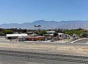
Thermal with the Santa Rosa Mountains in the Background
|
|

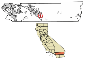
Location within Riverside County
|
|
| Country | United States |
| State | California |
| County | Riverside |
| Incorporated | April 20, 1938 |
| Area | |
| • Total | 9.384 sq mi (24.303 km2) |
| • Land | 9.384 sq mi (24.303 km2) |
| • Water | 0.00 sq mi (0.00 km2) 0.00% |
| Elevation | -138 ft (-43 m) |
| Population
(2020)
|
|
| • Total | 2,676 |
| • Estimate
(2021)
|
2,700 |
| • Density | 285.17/sq mi (110.110/km2) |
| Time zone | UTC−8 (Pacific) |
| • Summer (DST) | UTC−7 (PDT) |
| ZIP Codes |
92274
|
| Area codes | 442/760 |
| FIPS code | 06-55254 |
| GNIS feature IDs | 2583161 |
Thermal is a small community in Riverside County, California. It's in the Coachella Valley, about 25 miles (40 km) southeast of Palm Springs. It's also about 9.5 miles (15 km) north of the Salton Sea. This area is quite low, about 138 feet (43 meters) below sea level! People here use phone area codes 760 and 442. The ZIP Code is 92274. In 2020, about 2,676 people lived in Thermal.
Contents
History of Thermal
Early Beginnings
In 1823, Captain Jose Romero led a military trip. He found a route to Tucson from San Gabriel. This path went through the foothills west of Thermal. It also passed by the Martinez Indian Village, which is south of Thermal.
Thermal was first called Kokell. It started in 1910 as a camp for workers of the Southern Pacific Railroad. Later, other camps like Mecca (originally Walters) and Arabia also grew. By the 1930s, people built permanent homes along Avenue 56, which is now Airport Boulevard. This area was also near old U.S. Route 99 (now State Route 86) and State Route 111.
Growth and Development
By the 1950s, farming grew a lot thanks to water from canals. This made the area very green. In 1965, a former U.S. Naval Air station became the Thermal Airport. In the early 1990s, a new four-lane highway (State Route 86) was built. There are plans for a big new airport called the Jackie Cochran-Desert Cities Regional Airport at the same location.
The Thermal Club
The Thermal Club is a special place for car lovers. It's a private motorsports racetrack and club. It opened in 2012 and is located just south of the airport. In March 2024, the club hosted a big IndyCar Series race called the $1 Million Challenge. This race became a points-paying race for the 2025 season.
Geography and Climate
Where Thermal Is Located
Thermal covers an area of about 9.5 square miles (25.5 square kilometers). All of this area is land.
Thermal's Desert Climate
Thermal has a desert climate. This means it's very dry and hot. High mountains on three sides help make its weather unique. It has some of the warmest winters west of the Rocky Mountains.
- Average Temperatures: The average high temperature for the year is about 88.7°F (31.5°C). The average low is about 56.3°F (13.5°C).
- Hot Summers: Summer days often go above 110°F (43°C). This happens about 28 days each year. Temperatures can even go over 120°F (49°C) every other year. Summer nights often stay above 80°F (27°C).
- Warm Winters: Winters are warm. Daytime highs are rarely below 60°F (16°C). However, light freezes can happen every year.
- Rain and Sunshine: Thermal gets very little rain, less than 3 inches (76 mm) per year. It has over 348 sunny days each year!
- Temperature Records: The hottest temperature ever recorded was 126°F (52°C) on July 28, 1995. The coldest was 14°F (-10°C) on December 23, 1990.
| Climate data for Thermal, California (Desert Resorts Regional Airport, 1991–2020 normals, extremes 1950–present) | |||||||||||||
|---|---|---|---|---|---|---|---|---|---|---|---|---|---|
| Month | Jan | Feb | Mar | Apr | May | Jun | Jul | Aug | Sep | Oct | Nov | Dec | Year |
| Record high °F (°C) | 94 (34) |
100 (38) |
103 (39) |
110 (43) |
116 (47) |
123 (51) |
126 (52) |
122 (50) |
123 (51) |
114 (46) |
98 (37) |
93 (34) |
126 (52) |
| Mean maximum °F (°C) | 82.8 (28.2) |
86.4 (30.2) |
94.1 (34.5) |
101.9 (38.8) |
106.8 (41.6) |
114.4 (45.8) |
116.9 (47.2) |
116.0 (46.7) |
112.3 (44.6) |
103.4 (39.7) |
91.5 (33.1) |
80.8 (27.1) |
119.0 (48.3) |
| Mean daily maximum °F (°C) | 71.0 (21.7) |
74.3 (23.5) |
81.1 (27.3) |
87.2 (30.7) |
94.6 (34.8) |
103.0 (39.4) |
106.9 (41.6) |
106.2 (41.2) |
101.5 (38.6) |
90.9 (32.7) |
78.7 (25.9) |
69.3 (20.7) |
88.7 (31.5) |
| Daily mean °F (°C) | 55.0 (12.8) |
58.6 (14.8) |
65.0 (18.3) |
71.0 (21.7) |
78.7 (25.9) |
86.1 (30.1) |
91.2 (32.9) |
90.6 (32.6) |
84.8 (29.3) |
73.9 (23.3) |
61.7 (16.5) |
53.5 (11.9) |
72.5 (22.5) |
| Mean daily minimum °F (°C) | 39.0 (3.9) |
42.9 (6.1) |
49.0 (9.4) |
54.8 (12.7) |
62.9 (17.2) |
69.1 (20.6) |
75.6 (24.2) |
74.9 (23.8) |
68.2 (20.1) |
56.9 (13.8) |
44.7 (7.1) |
37.7 (3.2) |
56.3 (13.5) |
| Mean minimum °F (°C) | 27.2 (−2.7) |
30.5 (−0.8) |
36.6 (2.6) |
41.7 (5.4) |
50.5 (10.3) |
58.2 (14.6) |
64.0 (17.8) |
63.1 (17.3) |
55.6 (13.1) |
43.1 (6.2) |
31.3 (−0.4) |
25.0 (−3.9) |
23.4 (−4.8) |
| Record low °F (°C) | 17 (−8) |
19 (−7) |
24 (−4) |
32 (0) |
41 (5) |
50 (10) |
57 (14) |
52 (11) |
48 (9) |
28 (−2) |
20 (−7) |
14 (−10) |
14 (−10) |
| Average precipitation inches (mm) | 0.64 (16) |
0.61 (15) |
0.34 (8.6) |
0.08 (2.0) |
0.01 (0.25) |
0.01 (0.25) |
0.13 (3.3) |
0.12 (3.0) |
0.32 (8.1) |
0.19 (4.8) |
0.17 (4.3) |
0.34 (8.6) |
2.96 (74.2) |
| Average precipitation days (≥ 0.01 in) | 3.1 | 2.8 | 1.7 | 0.8 | 0.3 | 0.1 | 0.7 | 0.7 | 1.3 | 0.8 | 0.9 | 2.1 | 15.3 |
| Source: NOAA | |||||||||||||
People of Thermal
| Historical population | |||
|---|---|---|---|
| Census | Pop. | %± | |
| 2010 | 2,865 | — | |
| 2020 | 2,676 | −6.6% | |
| U.S. Decennial Census 2010 |
|||
Thermal was first counted as a special census area in the 2010 U.S. Census.
Population in 2020
The 2020 United States census showed that Thermal had 2,676 people. This means there were about 285 people per square mile.
- Racial Backgrounds:
- 15.1% White
- 0.6% African American
- 1.6% Native American
- 0.9% Asian
- 56.4% from other races
- 25.3% from two or more races
- Hispanic or Latino: 94.5% of the people were Hispanic or Latino.
Almost everyone (99.6%) lived in homes. A very small number (0.4%) lived in group housing.
Households and Families
There were 664 households in Thermal.
- 56.0% of households had children under 18.
- 54.8% were married couples.
- 21.8% had a female head of household with no partner.
- 16.1% had a male head of household with no partner.
- 13.6% of households had only one person.
- 6.0% of households had one person aged 65 or older.
The average household had 4.01 people. There were 554 families, which was 83.4% of all households.
Age Groups
- 32.5% were under 18 years old.
- 10.2% were aged 18 to 24.
- 27.1% were aged 25 to 44.
- 21.1% were aged 45 to 64.
- 9.0% were 65 years or older.
The average age was 29.6 years. For every 100 females, there were about 108.6 males.
There were 719 housing units. About 92.4% of these were lived in. Of the occupied homes, 48.8% were owned by the people living there. The other 51.2% were rented.
Education in Thermal
Thermal has several schools that are part of the Coachella Valley Unified School District. Some of these schools are in or near the community.
Elementary and Middle Schools
- Westside Elementary (Kindergarten to 6th grade)
- Oasis Elementary (Kindergarten to 8th grade)
- Mountain Vista Elementary (Kindergarten to 6th grade)
- Saul Martinez Elementary (Kindergarten to 6th grade)
- Mecca Elementary (Kindergarten to 6th grade)
- Edward Park Elementary (Kindergarten to 5th grade)
- John Kelley Elementary (Kindergarten to 6th grade)
- Cesar Chavez Elementary (Kindergarten to 6th grade)
- Toro Canyon Middle (6th to 8th grade)
- Bobby Duke Middle (6th to 8th grade)
- Cahuilla Desert Academy (Junior High: 7th and 8th grade)
High Schools
- Coachella Valley High (9th to 12th grade)
- Desert Mirage High School (9th to 12th grade)
- West Shores High School (9th to 12th grade)
- La Familia Continuation High (9th to 12th grade)
College Opportunities
College of the Desert is a community college. It has a new campus in Thermal called the East Valley Educational Center. It is located at the corner of 62nd Avenue and Buchanan Street.
Transportation and Services
Getting Around Thermal
The Jacqueline Cochran Regional Airport (once called Thermal Airport) is about 1.6 miles (2.6 km) southwest of the community. The Union Pacific Railroad owns and runs the main train line that goes through Thermal.
Thermal is also served by two main roads. California State Route 86 and California State Route 111 are important for transportation. They are used for shipping fruit and for international trucks. These roads connect to Interstate 10 in Indio.
Local Cemeteries
- The Toro Cemetery is located on Monroe Street.
- The Torres-Martinez Desert Cahuilla Indians have a small cemetery on Martinez Road.
See also
 In Spanish: Thermal (California) para niños
 | Lonnie Johnson |
 | Granville Woods |
 | Lewis Howard Latimer |
 | James West |


