Whitewater River (California) facts for kids
Quick facts for kids Whitewater River |
|
|---|---|

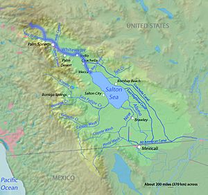
The course of the Whitewater River highlighted on a map of the Salton Sea drainage basin
|
|
| Country | United States |
| State | California |
| Cities | Palm Springs, Cathedral City, Palm Desert, Indio, Coachella, Mecca |
| Physical characteristics | |
| Main source | Confluence of North and Middle Forks Near San Gorgonio Mountain, San Bernardino Mountains, San Bernardino County 4,787 ft (1,459 m) 34°03′48″N 116°44′50″W / 34.06333°N 116.74722°W |
| River mouth | Salton Sea South of Mecca, Riverside County −233 ft (−71 m) 33°30′30″N 116°03′26″W / 33.50833°N 116.05722°W |
| Length | 53.9 mi (86.7 km) |
| Basin features | |
| Basin size | 1,500 sq mi (3,900 km2) |
| Tributaries |
|
The Whitewater River is a small, always-flowing stream in California. It runs through western Riverside County, California. Some of its smaller streams start in southwestern San Bernardino County. The river's beginning, called its headwaters, is in the San Bernardino Mountains. It ends at the Salton Sea in the Colorado Desert. The land that drains into the Whitewater River is part of a larger area. This area is a closed basin, meaning its water does not flow to the ocean.
Long ago, Spanish explorers called this river "Agua Blanco." This means "white water" in English. The river got its name because its water often looks milky. This is due to tiny bits of rock and minerals it carries. A town called Whitewater was even named after the river. It became an important stop for old stagecoach routes.

Contents
Journey of the Whitewater River
The Whitewater River flows through different types of land. It starts high in the mountains. Then it moves down into a wide valley.
Starting in the Mountains
The Whitewater River has three main branches. These are the North, Middle, and South Forks. All of them are found within the Sand to Snow National Monument.
The North Fork begins very high up on San Gorgonio Mountain. This area is like a high mountain meadow. It flows steeply downhill to meet the Middle Fork. The Middle Fork flows east through a wide, dry riverbed called an arroyo. The South Fork flows northeast through a narrower, wooded valley. It joins the Middle Fork further down.
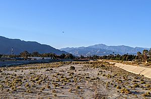
The upper parts of the river are in the San Gorgonio Wilderness and San Bernardino National Forest. Lower down, the land is managed by the Bureau of Land Management. After the branches join, the arroyo becomes very wide. It is filled with rocks, gravel, and sand from floods. Only small plants grow here, except in areas cleared by floodwaters. Because of floods, there are almost no trees along the riverbanks.
The Pacific Crest Trail (PCT) is a famous hiking trail. It follows the arroyo downstream to a park called Whitewater Preserve. Some Rainbow trout fish have made their way upstream here. These fish are not native to the area. They can only live in spots with shade or cooler water from other small streams. This is because the summer water temperatures are too high for them in most of the river.
Flowing Through Coachella Valley
Below the PCT trailhead, the hills open up. The arroyo leaves the San Bernardino Mountains near Morongo Valley. It then enters the western Coachella Valley. The San Gorgonio River joins the Whitewater River here. Other streams like Garnet Wash and Mission Creek also add water.
However, much of the water sinks into the sandy desert ground. This helps to refill the underground water supply, called an aquifer, in the Coachella Valley.
Sometimes, after heavy rains, surface water can reach the Salton Sea. The Salton Sea is a large lake that is actually below sea level.
The River in Pop Culture
In 2010, a TV show called California's Gold featured the Whitewater River. The show was hosted by Huell Howser. It explored the river and the nearby community.
 | Anna J. Cooper |
 | Mary McLeod Bethune |
 | Lillie Mae Bradford |


