Warner Springs, California facts for kids
Quick facts for kids
Warner Springs
|
|
|---|---|

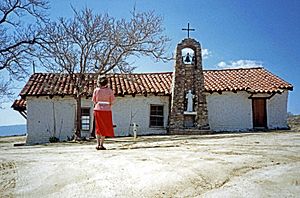
St Francis Mission Chapel
|
|
| Country | |
| State | |
| County | |
| Elevation | 954 m (3,130 ft) |
| Time zone | UTC-8 (Pacific (PST)) |
| • Summer (DST) | UTC-7 (PDT) |
| ZIP code |
92086
|
| Area code(s) | 442/760 |
| FIPS code | 06-83486 |
| GNIS feature ID | 251194 |
Warner Springs is a place in northern San Diego County, California. It is known for its natural hot springs and is a small community that is not officially a city. Warner Springs is also located right on the Pacific Crest Trail, a famous long-distance hiking path.
Contents
Geography
Warner Springs has its own post office and a ZIP code of 92086. It is close to the Palomar Observatory, which is a famous place for looking at stars. It is also near the Warner Springs Ranch.
You can reach Warner Springs by taking State Route 79. This road connects to Temecula to the north and to Santa Ysabel and Julian to the south.
Climate
| Climate data for Warner Springs (1991–2020 normals) | |||||||||||||
|---|---|---|---|---|---|---|---|---|---|---|---|---|---|
| Month | Jan | Feb | Mar | Apr | May | Jun | Jul | Aug | Sep | Oct | Nov | Dec | Year |
| Record high °F (°C) | 87 (31) |
87 (31) |
90 (32) |
92 (33) |
102 (39) |
107 (42) |
110 (43) |
109 (43) |
106 (41) |
100 (38) |
93 (34) |
85 (29) |
110 (43) |
| Mean daily maximum °F (°C) | 61.5 (16.4) |
62.8 (17.1) |
64.4 (18.0) |
69.0 (20.6) |
76.7 (24.8) |
85.2 (29.6) |
93.9 (34.4) |
93.5 (34.2) |
87.6 (30.9) |
78.6 (25.9) |
65.4 (18.6) |
60.8 (16.0) |
75.0 (23.9) |
| Daily mean °F (°C) | 45.2 (7.3) |
46.3 (7.9) |
48.4 (9.1) |
51.8 (11.0) |
58.0 (14.4) |
65.1 (18.4) |
73.3 (22.9) |
73.5 (23.1) |
67.4 (19.7) |
59.4 (15.2) |
49.1 (9.5) |
45.1 (7.3) |
56.9 (13.8) |
| Mean daily minimum °F (°C) | 28.8 (−1.8) |
29.7 (−1.3) |
32.3 (0.2) |
34.6 (1.4) |
39.2 (4.0) |
45.0 (7.2) |
52.6 (11.4) |
53.4 (11.9) |
47.0 (8.3) |
40.2 (4.6) |
32.8 (0.4) |
29.3 (−1.5) |
38.7 (3.7) |
| Record low °F (°C) | 11 (−12) |
14 (−10) |
17 (−8) |
19 (−7) |
25 (−4) |
34 (1) |
31 (−1) |
28 (−2) |
22 (−6) |
12 (−11) |
9 (−13) |
9 (−13) |
9 (−13) |
| Average precipitation inches (mm) | 3.09 (78) |
3.66 (93) |
2.92 (74) |
1.20 (30) |
0.52 (13) |
0.08 (2.0) |
0.29 (7.4) |
0.92 (23) |
0.45 (11) |
0.76 (19) |
1.21 (31) |
2.44 (62) |
17.54 (443.4) |
| Average snowfall inches (cm) | 2.3 (5.8) |
0.9 (2.3) |
1.0 (2.5) |
0.4 (1.0) |
0.0 (0.0) |
0.0 (0.0) |
0.0 (0.0) |
0.0 (0.0) |
0.0 (0.0) |
0.0 (0.0) |
0.1 (0.25) |
0.5 (1.3) |
5.2 (13.15) |
| Source: WRCc | |||||||||||||
The weather in Warner Springs is generally warm, especially in summer. The area is also a popular spot for gliding, which is a sport where people fly in aircraft without an engine. This is because of the shape of the mountains nearby.
History
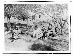
The Cupeño people were the first people to live in the Warner Springs area for a very long time. Their village, called Agua Caliente, was located right at the hot springs. Agua Caliente means "hot water" in Spanish.
Spanish explorers found these hot springs in 1795.
19th Century History
The Santa Ysabel Asistencia was like a small branch of a Spanish mission. It was started about 8 miles (13 km) south of the hot springs in 1818. Spanish missionaries from Mission San Diego de Alcalá built it.
Around 1830, the St. Francis of Assisi chapel was built near the settlement. Its walls were made from adobe mud bricks and painted white. The roof had red tiles made in the area. A stone bell tower stands next to the church.
Warner's Ranch
Juan Jose Warner was given a large piece of land, about 26,689 acres (108 km²), in 1844. He renamed the area Warner Springs. The same year, lands to the south became part of another land grant.
In 1851, the Cupeño people, led by a man named Garra, had a conflict at Warner's Ranch. This was part of a larger struggle against new settlers moving into their lands.
Warner's Ranch became an important stop for many travelers from 1849 to 1861. It was on the Southern Emigrant Trail, a path used by people moving west. Juan Jose Warner opened the only trading post for travelers between New Mexico Territory and Pueblo de Los Angeles in Alta California.
Later, it became a stop for mail and stagecoach lines, like the San Antonio-San Diego Mail Line (starting in 1857) and the Butterfield Overland Mail stagecoach line (1857–1861).
When the Civil War began in 1861, stagecoach service stopped. The Union Army set up Camp Wright at the ranch. This was a military outpost to protect the route from Southern California to Fort Yuma. It also helped stop people who supported the Confederate armies from joining them.
Former California Governor John Downey bought Warner Springs Ranch in 1880. He used it to raise cattle and sheep. For many years, there were disagreements with the Cupeños who lived at the ranch. In 1892, Downey went to court to try and remove them. In 1894, the U.S. Supreme Court decided against the Cupeños. They were ordered to leave in 1901, and their forced move two years later is known as the Cupeño Trail of Tears.
20th Century Developments
After the Cupeño people moved to the Pala Reservation, a resort was built at the springs. In 1908, there were about 20 small adobe houses and many tents for visitors. The old Indian school building was used as a dining hall. The hot water was cooled a bit and then sent to a bathhouse.
William Henshaw bought Warner Springs Ranch in 1911. He had the Henshaw Dam finished by late 1922, and its reservoir was full by 1924. In 1978, the water level in the reservoir had to be lowered by 40%. This was because of a danger from the Elsinore Fault Zone, an earthquake fault line that runs under the dam.
Many places and buildings in Warner Springs have been recognized as important historical sites. They are listed as California Historical Landmarks (CHL), National Historic Landmarks (NHL), or on the National Register of Historic Places (NRHP).
- Camp Wright (CHL)
- Oak Grove Butterfield Stage Station (CHL), (NHL), (NRHP)
- Warner's Ranch (CHL), (NHL), (NRHP)
See also
 In Spanish: Warner Springs para niños
 | William Lucy |
 | Charles Hayes |
 | Cleveland Robinson |


