City Creek (California) facts for kids
Quick facts for kids City Creek |
|
|---|---|

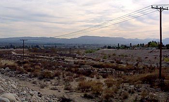
The nearly-dry bed of City Creek near Highland, California
|
|
|
Location of the mouth in California
|
|
| Country | United States |
| State | California |
| Region | San Bernardino County |
| City | Highland |
| Physical characteristics | |
| Main source | Confluence of East and West Forks 2,280 ft (690 m) 34°17′33″N 117°18′22″W / 34.29250°N 117.30611°W |
| River mouth | Santa Ana River East of San Bernardino International Airport 1,037 ft (316 m) 34°09′55″N 117°21′43″W / 34.16528°N 117.36194°W |
| Length | 7.5 mi (12.1 km), North-south |
| Basin features | |
| River system | Santa Ana River |
| Basin size | 19.6 sq mi (51 km2) |
| Tributaries |
|
City Creek is a small river, or tributary, that flows into the Santa Ana River in San Bernardino County, California. It is about 7.5 miles (12.1 km) long. The area of land that drains into City Creek, called its watershed, covers about 19.6 square miles (50.8 km²).
Contents
Where City Creek Starts
City Creek begins high up in the San Bernardino Mountains. It actually starts as two main branches, or forks, called the West Fork City Creek and the East Fork City Creek. Both of these forks are found within the San Bernardino National Forest.
West Fork City Creek
The West Fork starts near a place called Crest Summit. This is south of a small community named Crest Park. It begins at a high point, about 5,400 feet (1,646 meters) above sea level. This fork flows mostly south through deep, narrow valleys called gorges.
East Fork City Creek
The East Fork begins even higher, around 6,000 feet (1,829 meters) up in the mountains. It starts from several small valleys, or gulches, near Heaps Peak and Mount Sorenson. This fork flows south-southwest through a canyon (a deep valley with steep sides) past a place called Fredalba.
The Main Creek's Journey
The two forks of City Creek meet in a very steep, narrow valley. This meeting point is just below where the West Fork passes under a bridge for California State Route 330. This road is also known as City Creek Road.
After the forks join, the main part of City Creek flows south. It carves a deep gorge between McKinley and Harrison Mountains. As it leaves the mountains, the creek quickly drops down to the flatter lands near Highland.
Water Use and Flow
When City Creek reaches the plains near Highland, much of its water is taken out. This water is sent through canals to be used by people in homes and for watering crops on farms.
After this water is taken, the creek spreads out into wide, flat areas made of sand and gravel. Several other small streams, like Cook, Bledsoe, Elder Gulches, and Plunge Creek, join City Creek from the east side. The creek then flows along the east side of Highland in a wide channel designed to control floods.
Where City Creek Ends
Finally, City Creek flows into the Santa Ana River. This happens southeast of the San Bernardino International Airport.
 | Jewel Prestage |
 | Ella Baker |
 | Fannie Lou Hamer |


