
Moreno Valley, California facts for kids
Quick facts for kids
Moreno Valley, California
|
|||
|---|---|---|---|
|
The giant "M" on Box Springs Mountain for "Moreno Valley"
Moreno Valley City Hall
Sunnymead Ranch Lake
Aerial view of Moreno Valley
|
|||
|
|||
| Nickname(s):
"MoVal"
|
|||
| Motto(s):
"Where Dreams Soar"
|
|||
| Country | United States | ||
| State | California | ||
| County | Riverside | ||
| Incorporated | December 3, 1984 | ||
| Government | |||
| • Type | Council-Manager | ||
| Area | |||
| • Total | 51.51 sq mi (133.41 km2) | ||
| • Land | 51.30 sq mi (132.86 km2) | ||
| • Water | 0.21 sq mi (0.55 km2) 0.39% | ||
| Elevation | 1,631 ft (497 m) | ||
| Population
(2020)
|
|||
| • Total | 208,634 | ||
| • Rank | 2nd in Riverside County 21st in California 109th in the United States |
||
| • Density | 4,153.36/sq mi (1,603.62/km2) | ||
| Time zone | UTC−8 (Pacific) | ||
| • Summer (DST) | UTC−7 (PDT) | ||
| ZIP codes |
92551–92557
|
||
| Area codes | 909, 951 | ||
| FIPS code | 06-49270 | ||
| GNIS feature IDs | 1668251, 2411159 | ||
.JPG)


Moreno Valley is a city in Riverside County, California, United States. It's part of a larger metropolitan area that includes Riverside and San Bernardino. With over 208,000 people in 2020, it's the second-largest city in Riverside County. It's also considered part of the bigger Greater Los Angeles area.
The city got its name from a smaller community called Moreno. This community became part of Moreno Valley when the city was officially formed in 1984. Frank E. Brown, one of the founders of the Moreno community in 1882, didn't want the town named after him. Instead, they chose "Moreno," which means "brown" in Spanish, to honor him.
Contents
History of Moreno Valley
Early Inhabitants
People first lived in the Moreno Valley area about 2,300 years ago. Over 200 ancient sites have been found here. Most of these sites were places where people ground seeds from plants like chaparral. There are also examples of rock art, including pictographs (paintings on rock) and petroglyphs (carvings in rock). Many petroglyphs in Moreno Valley are boulders with small, cup-shaped holes carved into them.
Spanish and Mexican Influence
.jpg)
When Spanish explorers first arrived, they met people from the Shoshone and Luiseño tribes. Other groups like the Serrano and Cahuilla also lived in the area. These tribes often lived in villages during winter. In spring and summer, they would spread out in family groups to gather seeds and acorns.
Spanish explorers created several trails in the area. One important trail was the Anza Trail, which goes through the Edgemont part of what is now Moreno Valley.
Becoming Part of the United States
After California became a U.S. state in 1850, more Americans moved to the area. A mail route, the Overland Mail Company from Tucson to San Francisco, passed through here. Some farmers settled, using water from the Bear Valley Land and Water Company. This company pumped water from the San Bernardino Mountains. The area was first called Moreno Valley around this time, named after Frank Brown (moreno means "brown" in Spanish).
In 1899, the city of Redlands won a lawsuit over the water rights. This meant the Bear Valley water supply was lost, and most people had to leave the area.
City Growth and Formation
By 1984, the population of the area had grown to nearly 50,000 people. This was a big jump from about 18,000 residents in 1970. The economy was booming, and many new homes and businesses were built. This led to a strong desire for the area to become an official city.
Even though attempts to form a city had failed before, voters approved the idea in 1984. On December 3, 1984, the communities of Edgemont, Sunnymead, and Moreno joined together. They formed the city of Moreno Valley. The first city council was also elected that year. The city's official seal and motto were chosen the next year.
March Air Reserve Base
March Air Reserve Base is an important part of the area. In 2008, a company called DHL closed its operations linked to March Air Field.
Moreno Valley in the 21st Century
In 2007, the city council decided to name the eastern part of the city "Rancho Belago." This name is a mix of Spanish and Italian words.
Geography of Moreno Valley
Moreno Valley covers about 51.5 square miles (133.4 square kilometers). Most of this area is land, with a small amount of water.
Moreno Valley is located in a key spot. To the east, you'll find the San Gorgonio Pass and Coachella Valley. To the south are Lake Perris, the city of Perris, and the San Jacinto Mountains. North of the city are the San Bernardino Valley and San Bernardino Mountains. The city of Riverside is to the west. Moreno Valley is also fairly close to Ontario International Airport.
One of the most noticeable natural features in Moreno Valley is Box Springs Mountain. This mountain is at the northwest edge of the city and stands tall over it. On the side of the mountain facing the city, there's a large letter "M." This "M" was built by private groups to help bring the community together. It's on public land and is kept up by volunteers. Lights were added to the "M" on December 3, 2005, to celebrate Moreno Valley's 21st birthday as a city. The lights were also turned on for the city's 25th anniversary in 2009. Many Eagle Scout projects have helped maintain the "M."
Climate in Moreno Valley
Moreno Valley has a mild semi-arid climate, which means it's usually dry but not extremely hot or cold. It also has some features of a Mediterranean climate. Summer temperatures often reach the 90s, and can sometimes go over 100°F.
- The warmest month is usually August.
- The highest temperature ever recorded was 118°F (48°C) in July 2018.
- The coolest month is usually December.
- The lowest temperature ever recorded was 22°F (-6°C) in 1974.
- Most of the rain falls in December.
| Climate data for Moreno Valley, California | |||||||||||||
|---|---|---|---|---|---|---|---|---|---|---|---|---|---|
| Month | Jan | Feb | Mar | Apr | May | Jun | Jul | Aug | Sep | Oct | Nov | Dec | Year |
| Record high °F (°C) | 97 (36) |
92 (33) |
98 (37) |
104 (40) |
108 (42) |
112 (44) |
118 (48) |
113 (45) |
115 (46) |
108 (42) |
98 (37) |
93 (34) |
118 (48) |
| Mean daily maximum °F (°C) | 68 (20) |
68 (20) |
72 (22) |
76 (24) |
81 (27) |
89 (32) |
95 (35) |
96 (36) |
92 (33) |
83 (28) |
74 (23) |
67 (19) |
80 (27) |
| Mean daily minimum °F (°C) | 43 (6) |
44 (7) |
46 (8) |
49 (9) |
54 (12) |
57 (14) |
62 (17) |
62 (17) |
59 (15) |
53 (12) |
46 (8) |
42 (6) |
51 (11) |
| Record low °F (°C) | 24 (−4) |
27 (−3) |
29 (−2) |
33 (1) |
38 (3) |
44 (7) |
49 (9) |
49 (9) |
42 (6) |
32 (0) |
26 (−3) |
22 (−6) |
22 (−6) |
| Average precipitation inches (mm) | 2.08 (53) |
1.72 (44) |
.68 (17) |
.45 (11) |
.31 (7.9) |
.01 (0.25) |
0 (0) |
0 (0) |
.08 (2.0) |
.32 (8.1) |
.74 (19) |
2.74 (70) |
9.94 (252) |
People and Population (Demographics)
| Historical population | |||
|---|---|---|---|
| Census | Pop. | %± | |
| 1990 | 118,779 | — | |
| 2000 | 142,381 | 19.9% | |
| 2010 | 193,365 | 35.8% | |
| 2020 | 208,634 | 7.9% | |
| U.S. Decennial Census | |||
Demographics is the study of a population, including things like age, gender, and ethnic background. Here's a look at Moreno Valley's population over the years.
Population in 2020
| Race / Ethnicity (NH = Non-Hispanic) | Pop 2000 | Pop 2010 | Pop 2020 | % 2000 | % 2010 | % 2020 |
|---|---|---|---|---|---|---|
| White alone (NH) | 45,881 | 36,573 | 27,670 | 32.22% | 18.91% | 13.26% |
| Black or African American alone (NH) | 27,536 | 33,195 | 31,582 | 19.34% | 17.17% | 15.14% |
| Native American or Alaska Native alone (NH) | 567 | 573 | 536 | 0.40% | 0.30% | 0.26% |
| Asian alone (NH) | 8,214 | 11,423 | 12,099 | 5.77% | 5.91% | 5.80% |
| Pacific Islander alone (NH) | 650 | 990 | 1,009 | 0.46% | 0.51% | 0.48% |
| Other race alone (NH) | 295 | 388 | 1,227 | 0.21% | 0.20% | 0.59% |
| Mixed race or Multiracial (NH) | 4,549 | 5,054 | 6,343 | 3.19% | 2.61% | 3.04% |
| Hispanic or Latino (any race) | 54,689 | 105,169 | 128,168 | 38.41% | 54.39% | 61.43% |
| Total | 142,381 | 193,365 | 208,634 | 100.00% | 100.00% | 100.00% |
Population in 2010
In 2010, the population of Moreno Valley was 193,365. About 99.7% of these people lived in homes.
There were 51,592 households in the city. Over half of these (55.4%) had children under 18 living there. The average household had about 3.74 people. The average family had about 3.99 people.
The median age in Moreno Valley was 28.6 years. This means half the people were younger than 28.6 and half were older. For every 100 females, there were about 95 males.
Most homes (64.7%) were owned by the people living in them. The rest (35.3%) were rented.
Population in 2000
In the 1990s, the number of Latino residents grew, becoming the largest group in the city. Moreno Valley has also become a popular place for African-American families to move to, especially after the 1992 Los Angeles riots.
Many businesses in Moreno Valley serve Spanish-speaking customers and celebrate Latin American cultures.
In 2000, there were 43,381 households. About 54% of these had children under 18. The average household size was 3.6 people. The median age was 27 years.
The median income for a household in the city was about $47,387. The most common backgrounds in Moreno Valley include German, English, Irish, Italian, and Nigerian. The most common languages spoken, besides English, are Spanish and Tagalog.
Economy
The economy of Moreno Valley is supported by many different employers. Here are some of the largest ones in the city as of 2024:
| # | Employer | # of Employees |
|---|---|---|
| 1 | March Air Reserve Base | 7,000 |
| 2 | Riverside County Regional Medical Center | 4,790 |
| 3 | Amazon | 4,683 |
| 4 | Moreno Valley Unified School District | 3,678 |
| 5 | Ross Dress for Less / DD's Discounts | 1,861 |
| 6 | Kaiser Permanente Community Hospital | 1,616 |
| 7 | Harbor Freight Tools | 1,150 |
| 8 | Proctor & Gamble | 632 |
| 9 | Val Verde Unified School District | 655 |
| 10 | City of Moreno Valley | 517 |
Education
Moreno Valley has schools for all ages, from elementary to high school. Most students attend schools in the Moreno Valley Unified School District. This district serves about 35,000 students and has 35 schools, including five high schools. A smaller part of the city is served by the Val Verde Unified School District. This district has one high school, Rancho Verde High School, located in Moreno Valley. There are also some private schools and charter schools in the area.
For higher education, Moreno Valley College is part of the Riverside Community College District and serves 6,500 students. Chapman University also has a campus here. Students can also go to nearby colleges like the University of California, Riverside, La Sierra University, or California Baptist University. California State University, San Bernardino is another popular choice for high school graduates.
Moreno Valley has three public libraries where you can find books and resources.
Infrastructure
Transportation
Two major roads, State Route 60 (also known as the Moreno Valley Freeway) and Interstate 215, run through the city.
For public transport, Metrolink offers train service from the Moreno Valley/March Field station. This train connects the area to Riverside and Downtown Los Angeles to the north, and Perris to the south. The Riverside Transit Agency also provides local and express bus services.
Healthcare
Moreno Valley has two hospitals:
- Kaiser Permanente Community Hospital: This hospital provides general acute care and emergency services. Kaiser Permanente took over the hospital in 2008 and plans to make it larger.
- Riverside County Regional Medical Center: This hospital also offers general acute care and emergency services. It is also a Level I Trauma Center, which means it's equipped to handle the most serious injuries.
Notable People from Moreno Valley
Many talented people have lived in or are from Moreno Valley. Here are a few:
- Mark Contreras: Baseball outfielder
- Da'Mon Cromartie-Smith: Safety for the Pittsburgh Steelers
- Greg Dobbs: Third baseman for Philadelphia Phillies
- Natalie Duran: Rock climber
- Lindsay Ellingson: Model
- Becky G: Singer and actress
- Andrew Garcia: Singer-songwriter
- Elisabeth Harnois: American actress
- Kawhi Leonard: Professional basketball player with the Los Angeles Clippers
- Ryan Madson: Washington Nationals pitcher
- Troy Percival: Former Anaheim Angels All-Star Pitcher and World Series Champion
- Ronald Powell: Professional football player
- AJ Rafael, Filipino-American singer-songwriter
- Tyron Smith: Dallas Cowboys offensive lineman
- Derrick Ward: New York Giants running back
- Beverly Yanez: Former American professional soccer player
Sister Cities
Moreno Valley has one sister city:
 San Juan de los Lagos, Mexico
Images for kids
-
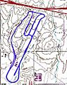
From 1957 to 1989, the Riverside International Raceway was located where the Moreno Valley Mall is now.
-
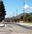
A view of Moreno Valley looking west down Ironwood Avenue. Box Springs Mountain is visible on the right.
-
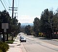
Southern Moreno Valley, viewed looking south down Kitching Street.


See also
 In Spanish: Moreno Valley (California) para niños
