
Menifee, California facts for kids
Quick facts for kids
Menifee, California
|
||
|---|---|---|
| City of Menifee | ||

Menifee City Hall
|
||
|
||

Location in Riverside County and the state of California
|
||

Menifee, California
Location in southern California

Menifee, California
Location in California

Menifee, California
Location in the United States
|
||
| Country | ||
| State | ||
| County | ||
| Region | Southern California | |
| Incorporated | October 1, 2008 | |
| Government | ||
| • Type | Council-Manager | |
| Area | ||
| • Total | 46.62 sq mi (120.75 km2) | |
| • Land | 46.48 sq mi (120.37 km2) | |
| • Water | 0.15 sq mi (0.38 km2) 0.30% | |
| Elevation | 1,424 ft (434 m) | |
| Population
(2020)
|
||
| • Total | 102,527 | |
| • Estimate
(2022)
|
109,399 | |
| • Rank | 6th in Riverside County 57th in California 288th in the United States |
|
| • Density | 2,353.68/sq mi (908.76/km2) | |
| Time zone | UTC−8 (Pacific) | |
| • Summer (DST) | UTC−7 (PDT) | |
| ZIP codes |
92584–92587, 92596
|
|
| Area code | 951 | |
| FIPS code | 06-46842 | |
| GNIS feature IDs | 252936, 2497157 | |

Menifee is a city in Riverside County, California, United States. It's part of a larger area called the Inland Empire. The city is named after a local miner, Luther Menifee Wilson.
Menifee was settled in the 19th century. It officially became a city in 2008. Since then, Menifee has grown very quickly. It is now one of the fastest-growing cities in California and the United States.
The city is located in the Menifee Valley in Southern California. It is about 15 miles (24 km) north of Temecula. Menifee is about 46 square miles (120 km2) in size. Its elevation is 1,424 feet (434 m) above sea level. The city includes the communities of Sun City, Quail Valley, and Romoland.
Contents
History of Menifee
The land where Menifee is located originally belonged to the Luiseño people. In the 1700s, the area came under Spanish rule. Later, in 1848, it became part of the United States after the Mexican–American War.
Farming started in the Menifee area in the mid-1800s. Mining began in the early 1880s. This was after a miner named Luther Menifee Wilson found a lot of quartz. The city of Menifee gets its name from him. In 1883, Wilson found gold in a quartz rock near what is now Holland and Murrieta roads. He named his new mine "Menifee." At that time, the whole area was called the Menifee Valley.
The community of Sun City was developed in the early 1960s. It was planned as a place for active retired people. Del Webb, a builder from Phoenix, Arizona, created it. He also built Sun City, Arizona, with the same idea. Sun City is in the northwest part of Menifee. It has both homes and businesses.
The Menifee area grew more in the late 1980s and early 1990s. It was planned as a community with many different areas. For a while, there weren't enough jobs or big stores. So, many people had to drive to cities like Temecula or Murrieta to shop, eat, or work.
However, Menifee has grown a lot recently. Many new people have moved here from other parts of Southern California. On June 3, 2008, the people living in the Menifee area voted to become a city. The City of Menifee officially started on October 1, 2008.
Geography and Climate
The city of Menifee is surrounded by other cities. These include Perris, Canyon Lake, Lake Elsinore, Wildomar, and Murrieta. The community of Winchester is also nearby. The center of Menifee is where Newport Road and Interstate 215 meet.
Menifee covers about 46.6 square miles (120.7 km2). Most of this area is land, with a small amount of water. The Menifee Hills are a ridge about 2 miles (3.2 km) long. Bell Mountain is a 1,848-foot (563 m) mountain located in Menifee.
Climate
| Weather chart for Menifee | |||||||||||||||||||||||||||||||||||||||||||||||
|---|---|---|---|---|---|---|---|---|---|---|---|---|---|---|---|---|---|---|---|---|---|---|---|---|---|---|---|---|---|---|---|---|---|---|---|---|---|---|---|---|---|---|---|---|---|---|---|
| J | F | M | A | M | J | J | A | S | O | N | D | ||||||||||||||||||||||||||||||||||||
|
1.8
68
39
|
2.3
67
40
|
0.7
72
44
|
0.6
76
48
|
0.2
83
54
|
0
89
58
|
0.2
97
65
|
0.1
98
64
|
0.1
94
60
|
0.6
82
52
|
0.9
75
44
|
2.1
66
38
|
||||||||||||||||||||||||||||||||||||
| temperatures in °F precipitation totals in inches source: weathercurrents.com/menifee |
|||||||||||||||||||||||||||||||||||||||||||||||
|
Metric conversion
|
|||||||||||||||||||||||||||||||||||||||||||||||
Menifee has mild winters and hot, dry summers.
- The warmest month is usually August. The average high temperature is about 99.1°F (37.3°C).
- The highest temperature ever recorded was 117°F (47°C) on June 20, 2016.
- December is usually the coldest month.
- The lowest temperature ever recorded was 18°F (-8°C) on January 1, 1976.
- Most rain falls in February.
Menifee has a Mediterranean climate. This means it gets lots of sunshine all year. On average, there are 263 sunny days. There are only about 35 days with measurable rain each year. The total rainfall is about 12.51 inches (31.8 cm).
From April to October, it is hot and dry. Average high temperatures are from 83°F to 101°F (28°C to 38°C). Lows are from 42°F to 66°F (6°C to 19°C). In summer, temperatures can easily go over 105°F (41°C). From November to March, it is a bit rainy. Sometimes in winter, large dust storms can happen. This is because of the humidity and flat land.
Population and People
| Historical population | |||
|---|---|---|---|
| Census | Pop. | %± | |
| 2010 | 77,519 | — | |
| 2020 | 102,527 | 32.3% | |
| 2022 (est.) | 109,399 | 41.1% | |
| U.S. Decennial Census | |||
The 2020 United States Census showed that Menifee had a population of 102,527 people. This means it's a growing city!
In 2010, the population was 77,519. Most people lived in homes, not in group living places. The average household had about 2.82 people. The average family had about 3.35 people.
About 25.9% of the people were under 18 years old. About 18.9% were 65 years or older. The median age was 38.1 years. This means half the people were younger than 38.1 and half were older.
Economy
The economy of a city is about how people make money and what businesses are there. In Menifee, many people work for schools and colleges.
Top Employers
Here are some of the biggest employers in Menifee, based on a 2023 report:
| # | Employer | # of Employees |
|---|---|---|
| 1 | Mt. San Jacinto College District | 1,604 |
| 2 | Menifee Union School District | 1,467 |
| 3 | Romoland Elementary School District | 602 |
| 4 | Stater Bros. | 348 |
| 5 | City of Menifee | 333 |
| 6 | Menifee Global Medical Center | 327 |
| 7 | Target Corporation | 312 |
| 8 | United Parcel Service (UPS) | 227 |
| 9 | Southern California Edison | 187 |
| 10 | Texas Roadhouse | 173 |
Parks and Recreation
Menifee has many places for fun and outdoor activities. As of June 2024, there are 45 public parks in Menifee. Twenty-one of these parks are owned by the city. The other 24 are owned by a larger park system called Valley-wide.
The Action Sports Park in Menifee is 6 acres (2.4 ha) big. It is the largest extreme bike park in Southern California.
Education in Menifee
Menifee has schools for all ages. Elementary and middle school students attend schools run by two different districts: the Menifee Union School District and the Romoland School District. The Menifee Union School District serves most of Menifee. It also serves parts of nearby cities like Lake Elsinore, Wildomar, and Murrieta.
High school students (grades 9-12) go to schools in the Perris Union High School District. These high schools include Paloma Valley High School, Heritage High School, and Liberty High School.
Menifee is also home to the Menifee Valley Campus of Mt. San Jacinto College. This college serves students from Temecula, Murrieta, and Menifee. It is known as the fastest-growing community college in California. Students can take classes here to prepare for a four-year college. The college also has a great nursing program. This program helps students become Registered Nurses. The MSJC Nursing Department has connections to local hospitals.
University of Massachusetts Global has also opened a campus at MSJC. This gives Menifee its first four-year college option.
K-12 Schools
- Boulder Ridge Elementary
- Callie Kirkpatrick Elementary School
- Chester W. Morrison Elementary School
- Evans Ranch Elementary School
- Freedom Crest Elementary School
- Harvest Hill STEAM Academy
- Harvest Valley Elementary
- Herk Bouris Elementary School
- Mesa View Elementary
- Oak Meadows Elementary School
- Quail Valley Elementary School
- Ridgemoor Elementary School
- Romoland Elementary
- Southshore Elementary School
- Táawila Elementary School
- Bell Mountain Middle School
- Ethan A. Chase Middle School
- Hans Middle School
- Kathryn Newport Middle School
- Menifee Valley Middle School
- Paloma Valley High School
- Heritage High School
- Liberty High School
- Santa Rosa Academy
Universities and Colleges
- Mt. San Jacinto College
Transportation and Water
Roads and Highways
The main roads in Menifee are Interstate 215 and Newport Road/Dominegoni Parkway. Other important roads for travel are Scott Road, McCall Boulevard, and Ethanac Road. State Route 74 runs through the northern part of the city. Murrieta, Bradley, Haun, Antelope, and Menifee Roads are the main north-south streets.
Improvements to the I-215 and Scott Road interchange were finished in 2020. More road projects are planned for the future. These include a new interchange at Garbani Road and an overpass at Holland Road.
Public Transportation
Menifee has bus routes and Dial-A-Ride stops. These help people get around the city. RTA bus routes 27, 40, 61, and 74 serve Menifee. They connect the city to nearby places like Temecula, Lake Elsinore, Hemet, and San Jacinto.
Metrolink is a train service that reaches the area. The 91/Perris Valley Line ends at the South Perris Station. This station is just north of Menifee. Metrolink might extend its service through Menifee to Hemet in the future.
Water
The Eastern Municipal Water District provides water to the city. There is a special plant in Menifee that cleans underground water. This plant turns it into safe drinking water.
Notable People
Many interesting people have connections to Menifee:
- Tony Burton - Actor
- Larry Fortensky - Construction worker and seventh husband of Elizabeth Taylor
- Fernando Gonzalez - MMA fighter
- Steve Lamson - Motocross racer
- Phyllis Love - Actress
- Benny Mardones - Singer
- Mike Metzger - Motocross rider
- Jamal Morrow - Football player
- Audie Murphy - Soldier, actor, and songwriter
- Matthew Orzech - Football player
- Nia Sanchez - Model and Miss USA 2014
Images for kids
-
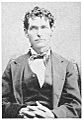
Luther Menifee Wilson, who the city is named after.
-
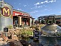
The Menifee Countryside Marketplace shopping center.
-
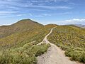
The Menifee Hills.
-
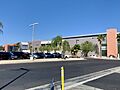
The Menifee Valley campus of Mt. San Jacinto College.


See also
 In Spanish: Menifee para niños
