Eastvale, California facts for kids
Quick facts for kids
Eastvale, California
|
|||
|---|---|---|---|
| City of Eastvale | |||

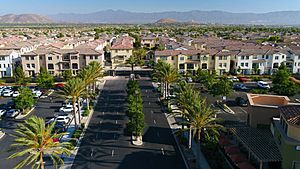
Eastvale, with Beacon Hill in the background
|
|||
|
|||
| Motto(s):
"Community, Pride, Prosperity"
|
|||

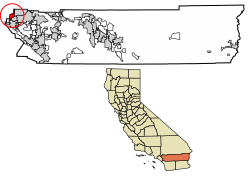
Location of Eastvale in Riverside County, California
|
|||
| Country | United States | ||
| State | California | ||
| County | Riverside | ||
| Incorporated | October 1, 2010 | ||
| Government | |||
| • Type | Council-Manager | ||
| Area | |||
| • Total | 13.11 sq mi (33.97 km2) | ||
| • Land | 12.67 sq mi (32.82 km2) | ||
| • Water | 0.44 sq mi (1.14 km2) 0.35% | ||
| Elevation | 627 ft (191 m) | ||
| Population
(2020)
|
|||
| • Total | 69,757 | ||
| • Density | 5,062.50/sq mi (1,954.59/km2) | ||
| Time zone | UTC-8 (PST) | ||
| • Summer (DST) | UTC-7 (PDT) | ||
| ZIP codes |
91752, 92880
|
||
| Area code(s) | 909, 951 | ||
| FIPS code | 06-21230 | ||
| GNIS feature IDs | 2629135, 2650583, 2650584 | ||
Eastvale is a city in northwestern Riverside County, California. It is part of the Inland Empire region in Southern California. This area used to be mostly dairy farms. But in the 1990s, it started to grow into a busy community. Eastvale officially became a city on October 1, 2010.
In 2020, about 69,757 people lived in Eastvale. The city's name comes from "East Vale," which was a school district listed way back in 1893. The current mayor of Eastvale is Christian Dinco.
Eastvale's borders stretch from Hellman Avenue in the west to Interstate 15 in the east. To the north is State Route 60, and to the south are the Santa Ana River and the city of Norco. Other cities around Eastvale include Chino, Ontario, Jurupa Valley, and Corona.
The Corona-Norco Unified School District serves the city. In 2020, the average household income in Eastvale was $151,615, which is one of the highest in the country.
Contents
Eastvale's History: How It Became a City
The story of Eastvale begins a long time ago. In 1838, a Mexican governor named Juan Alvarado gave a large piece of land called Rancho Jurupa to Juan Bandini. Eastvale now sits on about a quarter of that original land.
After the Mexican-American War ended in 1848, California became part of the United States. Then, on September 9, 1850, California became a U.S. state.
For many years, from 1889 to 1954, the Fuller family owned a big ranch here. This ranch covered about six square miles, including nearly half of what is now Eastvale.
The name "East Vale" was first used for an elementary school district in Riverside County. This was from 1893 until 1947, when it joined with Corona and Norco schools.
From Farms to Neighborhoods: Eastvale's Recent Growth
Eastvale was mostly farms and dairies until the late 1990s. Then, many people from Orange and Los Angeles counties started moving here. They were looking for homes that cost less. This caused Eastvale to grow quickly and become a suburban area.
Becoming a City: The Incorporation Story
Many communities in Riverside County wanted to become official cities. A state law, AB 1602, made it easier for areas like Eastvale to become cities. This law helped by adding funds from vehicle license fees.
People in Eastvale worked hard to make their community a city from the mid-2000s until 2010. A group called the Eastvale Incorporation Committee collected enough signatures to put the idea on the ballot.
On June 8, 2010, voters decided on "Measure A." This measure asked if Eastvale should become a city. "Measure B" asked how the city council members should be chosen. A large number of voters (65.8%) said "yes" to Measure A. So, Eastvale officially became a city on October 1, 2010! Voters also decided that city council members would be elected by everyone in the city. The first city council members were Ike Bootsma, Jeff DeGrandpre, Kelly Howell, Adam Rush, and Ric Welch. Adam Rush was chosen as Eastvale's first mayor.
Where is Eastvale Located?
Eastvale is about 8 miles northwest of the Los Angeles County line and 5 miles southwest of the Orange County line. These two counties have many jobs and businesses.
Eastvale is also located between major highways like Interstate 15 and State Routes 91, 60, and 71. Because of this great location, many people who work in Los Angeles or Orange counties choose to live in Eastvale. This makes Eastvale a popular place for people who travel to work.
Eastvale covers about 13.1 square miles. Most of this area (12.5 square miles) is land, and a small part (0.6 square miles) is water.
Eastvale has two ZIP codes: 92880 and 91752. Sometimes, mail to Eastvale might use "Corona" or "Mira Loma" as the city name. Most of Eastvale uses the 951 telephone area code. However, some older phone lines still use the 909 area code.
What is Eastvale's Climate Like?
Eastvale has a warm Mediterranean climate. This means it has mild winters and hot summers. Most of the rain falls during winter and early spring.
In winter, temperatures can get cold enough for frost. But winter days are usually nice, around 65 degrees Fahrenheit. Sometimes it even warms up into the 70s. Summers are hot, with average high temperatures in the low 90s. On the hottest days, temperatures in Eastvale can go above 100 degrees Fahrenheit.
| Climate data for Eastvale, California | |||||||||||||
|---|---|---|---|---|---|---|---|---|---|---|---|---|---|
| Month | Jan | Feb | Mar | Apr | May | Jun | Jul | Aug | Sep | Oct | Nov | Dec | Year |
| Record high °F (°C) | 94 (34) |
95 (35) |
101 (38) |
102 (39) |
108 (42) |
110 (43) |
111 (44) |
112 (44) |
115 (46) |
109 (43) |
99 (37) |
94 (34) |
115 (46) |
| Mean daily maximum °F (°C) | 68 (20) |
70 (21) |
71 (22) |
78 (26) |
80 (27) |
88 (31) |
92 (33) |
94 (34) |
91 (33) |
83 (28) |
74 (23) |
68 (20) |
80 (27) |
| Mean daily minimum °F (°C) | 42 (6) |
43 (6) |
45 (7) |
48 (9) |
52 (11) |
57 (14) |
61 (16) |
62 (17) |
60 (16) |
52 (11) |
45 (7) |
40 (4) |
51 (10) |
| Record low °F (°C) | 23 (−5) |
26 (−3) |
28 (−2) |
30 (−1) |
32 (0) |
42 (6) |
47 (8) |
43 (6) |
41 (5) |
29 (−2) |
26 (−3) |
22 (−6) |
22 (−6) |
| Average precipitation inches (mm) | 3.16 (80) |
3.42 (87) |
2.63 (67) |
.76 (19) |
.19 (4.8) |
.04 (1.0) |
.04 (1.0) |
.11 (2.8) |
.25 (6.4) |
.39 (9.9) |
1.42 (36) |
2.24 (57) |
14.65 (372) |
Who Lives in Eastvale? (Demographics)
| Historical population | |||
|---|---|---|---|
| Census | Pop. | %± | |
| 2010 | 53,668 | — | |
| 2020 | 69,757 | 30.0% | |
| U.S. Decennial Census 1850–1870 1880-1890 1900 1910 1920 1930 1940 1950 1960 1970 1980 1990 2000 2010 2020 |
|||
Eastvale was first counted as a "census designated place" in the 2010 U.S. Census. Then, it was counted as a city in the 2020 U.S. Census.
Eastvale's Population in 2020
In 2020, Eastvale had a population of 69,757 people.
| Race / Ethnicity (NH = Non-Hispanic) | Pop 2010 | Pop 2020 | % 2010 | % 2020 |
|---|---|---|---|---|
| White alone (NH) | 12,712 | 13,603 | 23.69% | 19.50% |
| Black or African American alone (NH) | 4,914 | 6,061 | 9.16% | 8.69% |
| Native American or Alaska Native alone (NH) | 102 | 117 | 0.19% | 0.17% |
| Asian alone (NH) | 12,770 | 20,654 | 23.79% | 29.61% |
| Pacific Islander alone (NH) | 156 | 185 | 0.29% | 0.27% |
| Other Race alone (NH) | 110 | 377 | 0.20% | 0.54% |
| Mixed Race or Multi-Racial (NH) | 1,459 | 2,596 | 2.72% | 3.72% |
| Hispanic or Latino (any race) | 21,445 | 26,164 | 39.96% | 37.51% |
| Total | 53,668 | 69,757 | 100.00% | 100.00% |
The racial makeup of the city was:
- 26.5% White
- 30.1% Asian
- 9.1% Black or African American
- 0.2% Pacific Islander
- 0.2% Native American
- 12.8% other races
- 8.1% from two or more races.
About 37.5% of the people were Hispanic or Latino (of any race).
Eastvale's Population in 2010
In 2010, Eastvale had 53,668 people. The population density was about 4,689 people per square mile.
- 42.9% White
- 24.2% Asian
- 9.7% African American
- 0.5% Native American
- 0.4% Pacific Islander
- 17.1% from other races
- 5.2% from two or more races.
About 40.0% of the people were Hispanic or Latino of any race.
There were 13,640 households in Eastvale. About 62.7% of these households had children under 18. The average household had 3.93 people. Most people (81.9%) lived in homes they owned, while 18.1% lived in rented homes.
In 2010, the average household income in Eastvale was $109,841. Only a small number of people (3.6%) lived below the poverty line.
Eastvale's Economy: Top Employers
Eastvale has many businesses that provide jobs. Here are the top employers in the city as of 2023:
| # | Employer | # of Employees |
|---|---|---|
| 1 | Amazon Fulfillment Center - LGB3 | 4,918 |
| 2 | Walmart Distribution Center | 952 |
| 3 | Corona-Norco Unified School District | 755 |
| 4 | Costco | 333 |
| 5 | Ingram Micro | 303 |
| 6 | Grainger Inc. | 250 |
| 7 | Home Depot | 199 |
| 8 | Komar Distribution Services | 161 |
| 9 | Kohl's | 100 |
| 10 | Albertsons | 88 |
Eastvale Community Spirit
The people of Eastvale are very involved in their community. The Eastvale Community Committee (ECC) was created in 2002. This group helps deal with issues in the growing community. They hold public meetings with local leaders, police, school representatives, and business owners. Volunteers also publish a newsletter called Eastvale Edition with meeting summaries and other news.
Another group, Eastvale Events, helps organize fun activities for everyone. Some of these events include the Eastvale Picnic in the Park, Eastvale Holiday Showcase, and Eastvale Fall Festival. These events help bring the community together.
Schools in Eastvale
Eastvale is part of the Corona-Norco Unified School District.
Elementary Schools
- Clara Barton Elementary School
- Harada Elementary School
- Ronald Reagan Elementary School
- Rosa Parks Elementary School
- Eastvale Elementary School
- Rondo School of Discovery
- Academy of Innovation (in and around Eastvale)
Intermediate Schools
- River Heights Intermediate School
- Dr. Augustine Ramirez Intermediate School
High Schools
- Eleanor Roosevelt High School
Images for kids
See also
 In Spanish: Eastvale (California) para niños
 | Bessie Coleman |
 | Spann Watson |
 | Jill E. Brown |
 | Sherman W. White |


