Temescal Valley, California facts for kids
Quick facts for kids
Temescal Valley
|
|
|---|---|

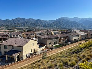
Temescal Valley homes with Santa Ana Mountains in the background
|
|
| Country | United States |
| State | California |
| County | Riverside |
| Area | |
| • Total | 19.338 sq mi (50.085 km2) |
| • Land | 19.302 sq mi (49.993 km2) |
| • Water | 0.036 sq mi (0.092 km2) 0.18% |
| Elevation | 1,138 ft (347 m) |
| Population
(2010)
|
|
| • Total | 22,535 |
| • Density | 1,165.32/sq mi (449.935/km2) |
| Time zone | UTC-8 (Pacific (PST)) |
| • Summer (DST) | UTC-7 (PDT) |
| GNIS feature ID | 2629134 |
Temescal Valley is a community in Riverside County, California. Its name, "Temescal," comes from a Spanish word for a "sweat lodge." This area is about 1,138 feet (347 meters) above sea level. In 2010, about 22,535 people lived in Temescal Valley.
Contents
History of Temescal Valley
Temescal Valley has a long and interesting history. It started as a large ranch and later became a busy mining area.
How Did Temescal Valley Get Its Name?
The name Temescal Valley comes from a large ranch called Rancho Temescal. Leandro Serrano started this ranch around 1818 or 1819. He got permission from a priest or military leader to use the land. The Serrano family lived on this land for many years. A special rock, the Serrano Boulder, marks where Leandro Serrano built his first house in 1824. The family lost the land in 1866 after a court case.
Temescal Station and Early Settlement
In 1857, the Butterfield Overland Mail stagecoach line set up a stop here. It was called Temescal Station. This station was a good place for travelers to rest. It had plenty of wood and water. Over time, a small town grew around this station.
By 1860, Temescal Canyon had a polling place for elections. A post office opened in 1861. However, it closed later that year because of the American Civil War.
Schools and Farming in Temescal
In 1866, the Temescal School District was created. It was the fifth school district in San Bernardino County. The first schoolhouse was built under a huge sycamore tree. A new school building replaced it in the early 1900s.
During the 1870s, farming changed in the valley. People started growing fruit trees and keeping bees. Bees became a very important way to earn money. Temescal got its own post office again in 1874.
The Temescal Tin Mine
In 1856, a man named Abel Stearns thought there was tin on the ranch. He bought a share of Rancho Temescal. But he had to sell it in 1864 because of a bad drought.
After 1866, a tin mine was developed east of Temescal. It started producing tin by 1869. However, who owned the land was still unclear. This stopped more work at the mine until 1888.
Once the land ownership was settled, experts from England came to look at the mine. They said it looked promising. So, new companies were formed to work the mine. The Temescal tin mine opened in 1890. Many miners came, and Temescal grew bigger. The mine produced 136 tons of tin by 1892. This was the first and last shipment. The mine closed down that same year.
The Rise of Corona and Temescal's Decline
In 1886, a new company was formed. It bought land in the area, including parts of Rancho Temescal. This company planned a new community called South Riverside. They also got rights to the water from Temescal Creek.
Dams and pipes were built to bring water to the new community. In 1889, the Temescal Water Company was created. This company drilled wells to find more water. At first, water flowed easily from the wells. But soon, pumps were needed to get the water out.
Over time, all the water from Temescal and Coldwater Creeks was sent away. The valley became dry. Farms and orchards in the middle of Temescal Valley were left empty. Old buildings along the stagecoach route fell apart. By 1901, the Temescal post office closed. Mail services moved to the new Corona post office.
Geography and Climate
Temescal Valley covers about 19.3 square miles (50.1 square kilometers). Most of this area is land. Only a small part is water.
| Climate data for Temescal Valley, California | |||||||||||||
|---|---|---|---|---|---|---|---|---|---|---|---|---|---|
| Month | Jan | Feb | Mar | Apr | May | Jun | Jul | Aug | Sep | Oct | Nov | Dec | Year |
| Record high °F (°C) | 85 (29) |
86 (30) |
90 (32) |
95 (35) |
103 (39) |
108 (42) |
108 (42) |
110 (43) |
114 (46) |
102 (39) |
93 (34) |
82 (28) |
114 (46) |
| Mean daily maximum °F (°C) | 63 (17) |
65 (18) |
67 (19) |
73 (23) |
79 (26) |
87 (31) |
94 (34) |
95 (35) |
89 (32) |
80 (27) |
70 (21) |
63 (17) |
77 (25) |
| Mean daily minimum °F (°C) | 37 (3) |
38 (3) |
40 (4) |
43 (6) |
48 (9) |
53 (12) |
57 (14) |
58 (14) |
55 (13) |
48 (9) |
40 (4) |
36 (2) |
46 (8) |
| Record low °F (°C) | 24 (−4) |
22 (−6) |
24 (−4) |
28 (−2) |
38 (3) |
39 (4) |
46 (8) |
46 (8) |
42 (6) |
32 (0) |
28 (−2) |
23 (−5) |
22 (−6) |
| Average precipitation inches (mm) | 3.42 (87) |
3.52 (89) |
2.52 (64) |
0.83 (21) |
0.28 (7.1) |
0.06 (1.5) |
0.03 (0.76) |
0.24 (6.1) |
0.30 (7.6) |
0.41 (10) |
1.22 (31) |
1.94 (49) |
14.77 (375) |
Who Lives in Temescal Valley?
The 2010 United States Census counted 22,535 people living in Temescal Valley. Most people (65.6%) were White. About 9.6% were Asian, and 6.7% were African American. About 30% of the people identified as Hispanic or Latino.
Almost everyone lived in homes. There were 7,142 households in total.
- 45.2% of households had children under 18.
- About 70% were married couples.
- The average household had 3.15 people.
Many young people live in Temescal Valley.
- 28.7% of the population was under 18 years old.
- 28.6% were between 25 and 44 years old.
- The average age was 36.2 years.
Most homes (87.3%) were owned by the people living in them. The rest were rented.
 | Dorothy Vaughan |
 | Charles Henry Turner |
 | Hildrus Poindexter |
 | Henry Cecil McBay |


