
Shelter Valley, California facts for kids
Quick facts for kids
Shelter Valley
|
|
|---|---|

Shelter Valley
Location in California

Shelter Valley
Location in the United States
|
|
| Country | |
| State | |
| County | |
| Elevation | 2,320 ft (707 m) |
| Population | |
| • Total | 320 |
| Time zone | UTC-8 (Pacific) |
| • Summer (DST) | UTC-7 (PDT) |
| ZIP codes |
92036
|
| Area codes | 442/760 |
| GNIS feature ID | 2664910 |
Shelter Valley is a small community in San Diego County, California. It is located along County Route S2. This road is about two miles (3.2 km) south of where it meets State Route 78. That meeting point is known as Scissors Crossing. Shelter Valley is also about 12 miles east of Julian.
This community is special because it sits inside the Anza-Borrego Desert State Park. It is also near a natural area called Earthquake Valley. The famous Pacific Crest Trail runs along the northern edge of Shelter Valley.
Surrounded by Nature
Shelter Valley is almost completely surrounded by park land. In 1998, the Anza-Borrego Desert State Park bought land north of the community. This made Shelter Valley the second community to be fully surrounded by the park. The first was Borrego Springs.
More land was added to public areas around Shelter Valley. In 2004, the state bought parts of Rancho San Felipe. This land became part of the San Felipe Valley Wild Life Area. These purchases helped protect the natural beauty around the community.
Protecting the Community
Shelter Valley has faced challenges from wildfires. In 2011 and 2012, several large fires threatened the small community. The Banner Fire reached the edge of Shelter Valley. Another fire, called the Vallecito Lightning Complex, burned nearby.
Thankfully, CAL FIRE and the Shelter Valley Volunteer Fire Department worked together. They successfully stopped the fires. No buildings in Shelter Valley were lost. In 2012, the Shelter Valley fire station was improved. This helps the volunteers protect the area even better.
Gallery
- Shelter Valley, CA
-
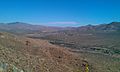
Shelter Valley seen from the north, along the Pacific Crest Trail.
-
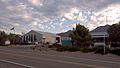
Shelter Valley California Fire Department and Community Center (2011)
-
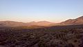
Shelter Valley (Earthquake Valley) after the 2012 Banner Fire. The foothills of Granite Mountain (the burn area) are visible to the right.

.jpg)
_after_the_2012_Banner_Fire.jpg)
See also
 In Spanish: Shelter Valley para niños
