
Northeast India facts for kids
Quick facts for kids
Northeast India
|
|
|---|---|
 |
|
 |
|
| Country | India |
| States | |
| Largest city | Guwahati |
| Major cities (2011 Census of India) | |
| Area | |
| • Total | 262,230 km2 (101,250 sq mi) |
| Population
(2011 Census of India)
|
|
| • Total | 45,772,188 |
| • Density | 174.550/km2 (452.082/sq mi) |
| Time zone | UTC+5:30 (Indian Standard Time) |
| Official languages | |
Northeast India is the easternmost part of India. It's a special area that is both a geographic region and a group of states. This region includes eight states: Arunachal Pradesh, Assam, Manipur, Meghalaya, Mizoram, Nagaland, Sikkim, and Tripura.
A narrow strip of land called the Siliguri Corridor in West Bengal connects Northeast India to the rest of the country. This region shares long international borders with several countries. It borders Tibet (China) to the north, Myanmar to the east, Bangladesh to the south-west, Nepal to the west, and Bhutan to the north-west. Northeast India covers about 262,230 square kilometers, which is almost 8% of India's total area.
The states in Northeast India are part of the North Eastern Council (NEC). This group was created in 1971 to help develop the region. Sikkim joined the North Eastern Region as the eighth state in 2002. India also has projects to connect Northeast India with China and ASEAN countries.
Contents
History of Northeast India
Early Settlers and Ancient Kingdoms

The first people to settle in Northeast India might have been speakers of Austroasiatic and Tibeto-Burman languages. They came from Southeast Asia. Later, Tibeto-Burmese speakers arrived from China. By 500 B.C., Indo-Aryan speakers from the Indo-Gangetic Plain also moved into the area.
Because of the many different plants and crops here, experts believe early settlers grew important plants. Ancient Chinese writings from 100 BC suggest there was an early trade route through Northeast India. Old texts also mention a group called Sêsatai in the region, who produced a valuable spice called malabathron.
During the first thousand years AD, a kingdom called Kamarupa covered most of present-day Northeast India. It also included parts of Bhutan and Bangladesh. A Chinese monk named Xuanzang visited Kamarupa in the 7th century. He described the people as "short and dark-looking." He noted their speech was a bit different from central India. He also said they were simple but could be violent. He wrote that people in Kamarupa knew about Sichuan, a place in China, which was beyond a difficult mountain.
For many tribal groups, their main identity comes from their smaller tribes and villages. These groups often have their own unique languages and cultures.
British Rule and State Formation


The northeastern states were formed during the time of the British Raj in the 1800s and early 1900s. During this period, the region became somewhat cut off from its usual trading partners like Bhutan and Myanmar. Many people in what are now Mizoram, Meghalaya, and Nagaland became Christians. This happened because of British missionaries.
In the early 1800s, both the Ahom and Manipur kingdoms were taken over by a Burmese invasion. This led to the First Anglo-Burmese War, and the whole region came under British control. From 1839 to 1873, Northeast India was part of the Bengal Province. Then, Assam became its own province.
After India gained independence from British rule in 1947, the Northeast region included Assam and the princely states of Manipur and Tripura. Over time, new states were created from the large territory of Assam. Nagaland was formed in 1963. Meghalaya was formed in 1972. Arunachal Pradesh and Mizoram became states in 1987. Manipur and Tripura were Union Territories before becoming full states in 1972. Sikkim joined as the eighth state of the North Eastern Council in 2002.
The city of Shillong was the capital of Assam during British rule. It remained the capital until Meghalaya was formed in 1972. Then, Assam's capital moved to Dispur (part of Guwahati), and Shillong became the capital of Meghalaya.
| State | Historic Name | Capital(s) | Statehood |
|---|---|---|---|
| Arunachal Pradesh | North-East Frontier Agency | Itanagar | 1987 (earlier a Union Territory of India, constituted in 1971) |
| Assam | Pragjyotisha, Kamarupa | Shillong (till 1969), Dispur | 1947 |
| Manipur | Kangleipak | Imphal | 1971 (earlier a Union Territory of India, constituted in 1956) |
| Meghalaya | Khasi hills, Jaintia hills and Garo hills | Shillong | 1971 |
| Mizoram | Lushai hills | Aizawl | 1987 (earlier a Union Territory of India, constituted in 1971) |
| Nagaland | Naga hills | Kohima | 1963 |
| Sikkim | Sukhim | Gangtok | 1975 |
| Tripura | Tipperah | Agartala | 1971 (earlier a Union Territory of India, constituted in 1956) |
The Seven Sister States

The term Seven Sister States is a popular name for seven states in Northeast India. These are Arunachal Pradesh, Assam, Meghalaya, Manipur, Mizoram, Nagaland, and Tripura. Sikkim was added later to the North Eastern Region.
A journalist from Tripura, Jyoti Prasad Saikia, first used the nickname "Land of the Seven Sisters." He used it during a radio show in January 1972, when the new states were officially opened. He later wrote a book about how these seven states are connected and similar, calling it Land of Seven Sisters. This book helped the nickname become very popular.
World War II and Sino-Indian War
In 1944, during World War II, Japanese forces tried to invade India through Burma. British and Indian troops stopped them at Kohima and Imphal. This was the farthest west the Japanese Empire reached. Their defeat here was a sign that the Allies would win the war.
Arunachal Pradesh, a state in the northeastern part of India, is claimed by China. This led to the Sino-Indian War in 1962. The exact reason for the war is still debated by both sides. During the war, China took control of much of the NEFA (North-East Frontier Agency), which India had created in 1954. However, on November 21, 1962, China declared a ceasefire and pulled its troops back. They also returned Indian prisoners of war in 1963.
Geography of Northeast India

Northeast India has three main geographical areas. These are the Eastern Himalaya mountains, the Patkai hills, and the plains of the Brahmaputra and Barak rivers. The region has a mostly humid subtropical climate. This means it has hot, humid summers, heavy monsoons, and mild winters.
This region has some of the last remaining rainforests in India. These forests are home to many different plants and animals. They also support various crop species. Northeast India also has large amounts of petroleum and natural gas. It is estimated to hold about one-fifth of India's total reserves.
The region is shaped by the powerful Brahmaputra-Barak river systems and their smaller rivers. Most of the area is hilly, with valleys and plains in between. The height of the land ranges from almost sea-level to over 7,000 meters above sea level. The region gets a lot of rain, averaging around 10,000 mm or more each year. This heavy rainfall causes problems like floods. The states of Arunachal Pradesh and Sikkim have a mountain climate. This means they have cold, snowy winters and mild summers.
-
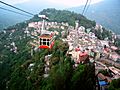
Ropeway, Gangtok -
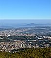
Aerial view of Shillong -
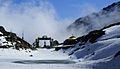
Sela Pass, Tawang (Arunachal Pradesh) -
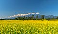
Bhalukpong, Arunachal Pradesh -
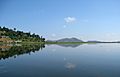
Loktak lake, Manipur -
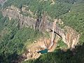
Nohkalikai Falls, Cherrapunji


Highest Peaks in Northeast India

Kangchenjunga is the third highest mountain peak in the world. It rises to an altitude of 8,586 meters. This massive mountain is located between the state of Sikkim and the country of Nepal.
| Peak | State | Range/Region | Height (m) | Height (ft) | Coordinates |
|---|---|---|---|---|---|
| Kangchenjunga (shared with Nepal) | Sikkim | Eastern Himalaya | 8,586 | 28,169 | 27°42′11″N 88°08′53″E / 27.703°N 88.148°E |
| Kangto (shared with Tibet) | Arunachal Pradesh | Eastern Himalaya | 7,090 | 23,261 | 27°51′54″N 92°31′59″E / 27.865°N 92.533°E |
| Mount Saramati (Shared with Myanmar) | Nagaland | Naga Hills | 3,841 | 12,602 | 25°44′31″N 95°01′59″E / 25.742°N 95.033°E |
| Mount Iso (also known as Tenipu) | Manipur | Senapati District | 2,994 | 9,823 | 25°31′52″N 94°05′06″E / 25.531°N 94.085°E |
| Phawngpui (Blue Mountain) | Mizoram | Saiha District | 2,165 | 7,103 | 22°37′55″N 93°02′20″E / 22.632°N 93.039°E |
| Shillong Peak | Meghalaya | Khasi Hills | 1,965 | 6,447 | 25°31′55″N 91°51′04″E / 25.532°N 91.851°E |
| Unnamed peak near Laike | Assam | Dima Hasao District | 1,960 | 6,430 | 25°19′16″N 93°27′11″E / 25.321°N 93.453°E |
| Betalongchhip | Tripura | Jampui Hills | 930 | 3,051 | 23°48′36″N 92°15′40″E / 23.810°N 92.261°E |
The Brahmaputra River Basin


The Brahmaputra River and its many smaller rivers flow through Northeast India. Here are some of its tributaries:
- Beki River
- Bhogdoi River
- Dhansiri River
- Dibang River
- Dihing River
- Kameng River
- Kolong
- Kopili River
- Lohit River
- Manas River
- Sankosh River
- Subansiri River
- Teesta River
Climate of Northeast India
Northeast India has a subtropical climate. This climate is affected by its mountains and the southwest and northeast monsoon winds. The Himalayas in the north, the Meghalaya plateau in the south, and the hills of Nagaland, Mizoram, and Manipur in the east all play a role. Monsoon winds from the Bay of Bengal are forced upwards by these mountains. This makes the air cool and form clouds, leading to heavy rain on the slopes.
It is the rainiest region in India. Many places receive an average of 2,000 mm of rain or more each year. Most of this rain falls in summer during the monsoon season. Cherrapunji, located on the Meghalaya plateau, is one of the wettest places in the world. It gets about 11,777 mm of rain annually. Temperatures are mild in the Brahmaputra and Barak river plains. They get colder as you go higher into the hilly areas. At the highest points, there is permanent snow.
High Risk Seismic Zone

Northeast India is an area prone to large earthquakes. This is because of active fault lines deep underground. These faults are formed where three tectonic plates meet: the India Plate, the Eurasian Plate, and the Burma Plate.
Historically, the region has experienced two very large earthquakes (over magnitude 8.0). These were the 1897 Assam earthquake and the 1950 Assam–Tibet earthquake. Since 1897, there have also been about 20 other large earthquakes (between magnitude 7.0 and 8.0). The 1950 Assam-Tibet earthquake is still the largest earthquake ever recorded in India.
Wildlife of Northeast India
Plant Life (Flora)
.jpg)
The WWF considers the entire Eastern Himalayas a very important Global 200 Ecoregion. Conservation International has also named the Eastern Himalaya as a biodiversity hotspot. This hotspot includes all eight states of Northeast India, plus parts of Bhutan, southern China, and Myanmar.
The Indian Council of Agricultural Research has identified this region as a key area for rice plants. The National Bureau of Plant Genetic Resources (NBPGR) in India says the region is rich in wild relatives of crop plants. It is also where citrus fruits first came from. Two old types of maize, Sikkim Primitive 1 and 2, have been found in Sikkim.
Traditional farming methods, like jhum cultivation (slash-and-burn), are sometimes blamed for losing forest cover. However, this farming method, used by local tribes, actually supports the growth of 35 different types of crops. The region has many medicinal plants and other rare and endangered species. Its high number of unique plants, animals, and birds makes it a true biodiversity hotspot.
Here are some facts about the amazing plant life in the region:
- There are 51 different forest types here. They are grouped into six main types: tropical moist deciduous, tropical semi-evergreen, tropical wet evergreen, subtropical, temperate, and alpine forests.
- Out of India's nine important plant types, six are found in Northeast India.
- These forests are home to 8,000 out of 15,000 species of flowering plants found in India. Arunachal Pradesh (5,000 species) and Sikkim (4,500 species) have the most diverse plant life among the northeastern states.
- According to the Indian Red Data Book, 10% of India's flowering plants are endangered. Of the 1,500 endangered plant species, 800 are found in Northeast India.
- Most of the Northeast states have over 60% of their land covered by forests. This is the minimum amount suggested for hill states to prevent soil erosion.
- Northeast India is part of the Indo-Burma hotspot. This is the second largest hotspot in the world, covering 2,206,000 square kilometers.
Animal Life (Fauna)


The International Council for Bird Preservation in the UK has identified the Assam plains and Eastern Himalaya as an Endemic Bird Area (EBA). This EBA covers 220,000 square kilometers. It follows the Himalayan range through Bangladesh, Bhutan, China, Nepal, Myanmar, and several Indian states.
Because this mountain range extends further south than other Himalayan ranges, it has a different climate. It has warmer average temperatures, fewer frosty days, and much more rainfall. This unique climate has led to many bird species that are found only in this region. More than two critically endangered, three endangered, and 14 vulnerable bird species live in this EBA.
The WWF has identified these important ecoregions in Northeast India:
- Brahmaputra Valley Semi-Evergreen Forests
- Eastern Himalayan Broadleaved Forests
- Eastern Himalayan Sub-alpine Coniferous Forests
- India–Myanmar Pine Forests
State Symbols
Each state in Northeast India has its own special animal, bird, flower, and tree.
| Arunachal Pradesh | Assam | Manipur | Meghalaya | |||||
|---|---|---|---|---|---|---|---|---|
| Animal | Mithun (Bos frontalis) | Indian rhinoceros (Rhinoceros unicornis) | Sangai (Rucervus eldii eldii) | Clouded leopard (Neofelis nebulosa) | ||||
| Bird | Hornbill (Buceros bicornis) | White-winged duck (Asarcornis scutulata) | Mrs. Hume's pheasant (Syrmaticus humiae) | Hill myna (Gracula religiosa) | ||||
| Flower | Foxtail orchid (Rhynchostylis retusa) | Foxtail orchid (Rhynchostylis retusa) | Siroi lily (Lilium mackliniae) | Lady's Slipper Orchid (Paphiopedilum insigne) | ||||
| Tree | Hollong (Dipterocarpus macrocarpus) | Hollong (Dipterocarpus macrocarpus) | Uningthou (Phoebe hainesiana) | Gamhar (Gmelina arborea) | ||||
| Mizoram | Nagaland | Sikkim | Tripura | |||||
| Animal | Himalayan serow (Capricornis thar) | Mithun (Bos frontalis) | Red panda (Ailurus fulgens) | Phayre's leaf monkey (Trachypithecus phayrei) | ||||
| Bird | Mrs. Hume's pheasant (Syrmaticus humiae) | Blyth's tragopan (Tragopan blythii) | Blood pheasant (Ithaginis cruentus) | Green imperial pigeon (Ducula aenea) | ||||
| Flower | Red Vanda (Renanthera imschootiana) | Tree rhododendron (Rhododendron arboreum) | Noble dendrobium (Dendrobium nobile) | Indian rose chestnut (Mesua ferrea) | ||||
| Tree | Indian rose chestnut (Mesua ferrea) | Alder (Alnus nepalensis) | Rhododendron (Rhododendron niveum) | Agarwood (Aquillaria agallocha) | ||||
People and Culture
Population and Cities
Northeast India has a total population of 46 million people. About 68% of them live in Assam alone. Assam also has more people per square kilometer (397) than the national average (382). Most states in the Northeast have higher literacy rates than the national average of 74%, except for Arunachal Pradesh and Assam.
According to the 2011 census, Meghalaya had the highest population growth in the region (27.8%). This was higher than the national average of 17.64%. Nagaland, however, had the lowest growth in the entire country, with a negative 0.5%.
Largest Cities by Population
Here are the largest cities in Northeast India, based on the 2011 Census of India:
| Rank | City | Type | State | Population | Rank | City | Type | State | Population |
|---|---|---|---|---|---|---|---|---|---|
| 1 | Guwahati | UA | Assam | 1,260,419 | 9 | Jorhat | UA | Assam | 153,249 |
| 2 | Agartala | City | Tripura | 522,613 | 10 | Nagaon | UA | Assam | 147,137 |
| 3 | Imphal | UA | Manipur | 414,288 | 11 | Tinsukia | UA | Assam | 125,637 |
| 4 | Dimapur | City | Nagaland | 379,769 | 12 | Dhubri | UA | Assam | 109,234 |
| 5 | Shillong | UA | Meghalaya | 354,325 | 13 | Tezpur | UA | Assam | 100,477 |
| 6 | Aizawl | City | Mizoram | 291,822 | 14 | Kohima | UA | Nagaland | 100,000 |
| 7 | Silchar | UA | Assam | 228,985 | 15 | Gangtok | City | Sikkim | 98,658 |
| 8 | Dibrugarh | UA | Assam | 154,019 | 16 | Itanagar | City | Arunachal Pradesh | 95,650 |
|
UA: Urban Agglomeration |
|||||||||
Languages of the Region
Northeast India is a unique language area within India. It has about 220 languages from different language families. These include Indo-European, Trans-Himalayan/Sino-Tibetan, Kra–Dai, and Austroasiatic. There are also some mixed languages. These languages share features that make them different from most other parts of India.
Official Languages by State
| State | Official Languages |
|---|---|
| Arunachal Pradesh | Hindi, English |
| Assam | Assamese, Bengali (in the Barak Valley), Bodo (in Bodoland) |
| Manipur | Meiteilon |
| Meghalaya | Khasi, Garo, English |
| Mizoram | Mizo, English |
| Nagaland | English |
| Sikkim | Nepali, English |
| Tripura | Bengali, Kokborok |
Religions in Northeast India
Here's a breakdown of religions in Northeast India, based on the 2011 Census:
| State | Hinduism | Islam | Christianity | Buddhism | Jainism | Sikhism | Other Religions | Religion Not Stated |
|---|---|---|---|---|---|---|---|---|
| Arunachal Pradesh | 401,876 | 27,045 | 418,732 | 162,815 | 771 | 3,287 | 362,553 | 6,648 |
| Assam | 19,180,759 | 10,679,345 | 1,165,867 | 54,993 | 25,949 | 20,672 | 27,118 | 50,873 |
| Manipur | 1,181,876 | 239,836 | 1,179,043 | 7,084 | 1,692 | 1,527 | 233,767 | 10,969 |
| Meghalaya | 342,078 | 130,399 | 2,213,027 | 9,864 | 627 | 3,045 | 258,271 | 9,578 |
| Mizoram | 30,136 | 14,832 | 956,331 | 93,411 | 376 | 286 | 808 | 1,026 |
| Nagaland | 173,054 | 48,963 | 1,739,651 | 6,759 | 2,655 | 1,890 | 3,214 | 2,316 |
| Sikkim | 352,662 | 9,867 | 60,522 | 167,216 | 314 | 1,868 | 16,300 | 1,828 |
| Tripura | 3,063,903 | 316,042 | 159,882 | 125,385 | 860 | 1,070 | 1,514 | 5,261 |
| Total | 24,726,344 | 11,466,329 | 7,893,055 | 627,527 | 33,244 | 33,645 | 903,545 | 88,499 |
Ethnic Groups and Diversity
Northeast India is home to over 220 different ethnic groups. They speak just as many different languages! The Bodo are the largest native ethnic group. The hilly states like Arunachal Pradesh, Meghalaya, Mizoram, and Nagaland are mostly home to tribal people. Even within these tribal groups, there's a lot of diversity. The people in this region come from ancient and continuous migrations. These migrations were from Tibet, Indo-Gangetic India, the Himalayas, present-day Bangladesh, and Myanmar.
-
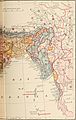
British India map of Northeast India by ethnicity, 1891 -
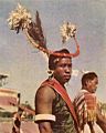
A Naga warrior in 1960 -
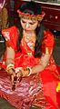
Bishnupuriya bride -
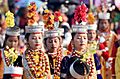
Shad suk Mynsiem, a Khasi festival -

Traditional Hajong Clothing -
Aka tribe, Arunachal Pradesh -

Mizo school girls -
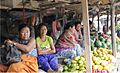
Women selling fruits in Senapati, Manipur -
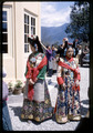
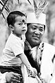
Princess of Sikkim in traditional royal dress -
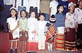
Tipra children in traditional attire grouping up for song presentation


Cuisines of Northeast India
The food in Northeast India is very diverse and delicious! Each state has its own unique dishes.
| State | Staple diet | Popular dishes | Related article |
|---|---|---|---|
| Arunachal Pradesh | Rice, fish, meat, leaf vegetables | Thukpa, momo, apong (rice beer) | Cuisine of Arunachal Pradesh |
| Assam | Rice, fish, meat, leaf vegetable | Assam tea, khar, tenga, pura, pitha, tamul (betel nut) – paan, rice beer | Assamese cuisine |
| Manipur | Rice, fish, local vegetables | Eromba, u-morok, singju, ngari (fermented fish), kangshoi | Cuisine of Manipur |
| Meghalaya | Rice, spiced meat, fish | Jadoh, ki kpu, minil, nakham (dried fish), momo, bamboo shoot | Cuisine of Meghalaya |
| Mizoram | Rice, fish, meat | Bai, bekang (fermented soya beans), sa-um (fermented pork), sawhchiar | |
| Nagaland | Rice, meat, stewed or steamed vegetables | fermented bamboo shoot, smoked pork and beef, axone, bhut jolokia | Naga cuisine |
| Sikkim | Rice, meat, dairy products | Thukpa, momo, sha Phaley, gundruk, sinki, sel roti | Sikkimese cuisine |
| Tripura | Rice, fish, meat | Fish stew, bamboo shoot, fermented fish | Bengali Cuisine, Tripuri cuisine |
-
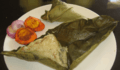
Bhangui - ethnic food of Tripura -
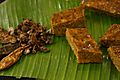
Paknam (Manipur) -
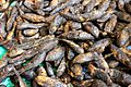
Smoked freshwater fish (Manipur) -

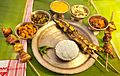
Thukpa - a popular Northeast India cuisine -
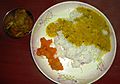
North Sikkim meal -
Assamese thali -
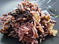
Red rice with pork (Arunachal Pradesh)


Arts and Crafts
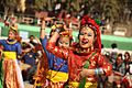
Sattriya (from Assam) and Manipuri dance (from Manipur) are recognized as classical dances of India. Besides these, all tribes in Northeast India have their own folk dances. These dances are often part of their religious ceremonies and festivals. The region has a rich tribal heritage, including hunting, farming, and traditional crafts. The vibrant culture is clearly seen in the traditional clothes of each community.
All states in Northeast India share common handicrafts. These include items made from bamboo and cane, wood carving, and making traditional weapons and musical instruments. Pottery and handloom weaving are also very important. Traditional tribal clothes are made from thick fabrics, usually cotton. Assam silk is a famous industry in the region.
| State | Traditional Performing Arts | Traditional Visual Arts | Traditional Crafts |
|---|---|---|---|
| Arunachal Pradesh | Wancho dances, Idu Mishmi dance, Digaru Mishmi Buiya dance, Khampti dance, Ponung dance, Sadinuktso | Cane and bamboo, cotton and wool weaving, wood carving, blacksmithy (hand tools, weapons, ornaments, dishes, sacred bells and smoking pipes) | |
| Assam | Sattriya, Bagurumba, Bihu dance, Bhaona (For more see Music of Assam) | Hastividyarnava (For more see Fine Arts of Assam) | Cane and bamboo, bell metal and brass, silk, toy and mask making, pottery and terracotta, jewellery, musical instruments making, boat making, paints |
| Manipur | Manipuri dance (Ras Lila), Kartal Cholam, Manjira Cholom, Khuba Kishei, Pung Cholam, Lai-Haraoba | Cotton textile, bamboo crafts (hats, baskets), pottery | |
| Meghalaya | Nongkrem, Shad suk, Behdienkhlam, Wangala, Lahoo dance (For more see Music of Meghalaya) | Making hand tools and weapons, musical instruments (drums), cane and bamboo work, weaving traditional attires, jewellery making (gold, coral, glass), wall engravings, wood carving | |
| Mizoram | Cheraw, Khuallam, Chheih-Lam, Chai, Rallu-Lam, Solakia, Sarlamkai, Par-lam, Sakei Lu Lam (For more see Music of Mizoram) | Traditional hand tools, weapons and textile work, bamboo and cane handicrafts | |
| Nagaland | Zeliang dance, war dance, Nruirolians (cock dance) (For more see Music of Nagaland) | Cane and bamboo crafts, traditional hand tools, weapons and textile work, wood carving, pottery, ornaments for traditional attire, musical instruments (drum and trumpet) | |
| Sikkim | Chu Faat dance, Lu Khangthamo, Gha To Kito, Rechungma, Maruni, Tamang Selo, Singhi Chaam, Yak Chaam, Khukuri dance, Rumtek Chaam (mask dance) (See also Music of Sikkim) | Thangka (showcasing Buddhist teachings on cotton canvas using vegetable dyes) | Handmade paper, carpet making, woollen textile, wood carving |
| Tripura | Goria dance, Jhum dance, Lebang dance, Mamita dance, Mosak sulmani dance, Hojagiri dance, Bizhu dance, Wangala, Hai-hak dance, Sangrai dance, Owa dance | Cane and bamboo, weaving and handloom, sitalpati (mat making), wood carving, string and wind musical instruments |
-

Sattriya dance (Assam) -
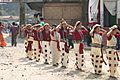
Nyokum festival of Nyishi tribe (Arunachal Pradesh) -
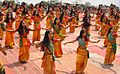
Bagurumba dance of Bodo tribe (Assam) -
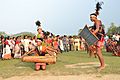
Wangala dance of Garo tribe (Assam, Meghalaya) -
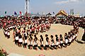
Dance of Angami tribe (Nagaland) -
Students performing traditional dance at Jorethang (Sikkim)


Economy and Tourism
The Ministry for Development of North Eastern Region (MDoNER) is a government body in India. Its job is to help with the social and economic development of Northeast India.
Industries and Agriculture
The economy of Northeast India is mostly based on farming. There isn't much land available for settled agriculture. Some local groups still practice jhum (slash-and-burn) cultivation. The difficult terrain and local issues have made it hard for industries to grow quickly in the region.


.jpg)

Tourism and Living Root Bridges

Northeast India is famous for its many Living root bridges. In Meghalaya, you can find these unique bridges in the southern Khasi and Jaintia Hills. While they are still common, some have been lost to floods or replaced by modern bridges. Living root bridges have also been seen in Nagaland, near the border with Myanmar.
Transportation
Air Travel


The states in Northeast India are well connected by air. There are regular flights to all major cities in India. The states also have smaller airstrips for military and private use. You can use Pawan Hans helicopter services to reach these. The region has two international airports: Lokapriya Gopinath Bordoloi International Airport and Bir Tikendrajit International Airport. These airports have flights to Thailand, Myanmar, Nepal, and Bhutan. While the airport in Sikkim is still being built, Bagdogra Airport is the closest domestic airport for that state.
Railway Network

The railway system in Northeast India is part of the Northeast Frontier Railway zone of Indian Railways. The train network in the region is still developing. States like Manipur, Meghalaya, Mizoram, Nagaland, and Sikkim were mostly disconnected by rail until recently (as of June 2017). However, projects are underway to expand the network and connect all the capital cities in the region.
Images for kids
-

Mizo girls in Mizo traditional dress
-
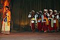
Lahoo Dance of Meghalaya
-
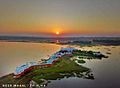
Neer Mahal of Tripura -

An Ao Naga girl in her traditional attire in Nagaland
-

Tripuri woman in traditional attire -

Asamiya youth in Bihu attire.
-

Basic Tripuri lunch thali -
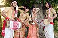
Assamese youths performing Bihu dance.


See also
 In Spanish: Noreste de India para niños
