
Shillong facts for kids
Quick facts for kids
Shillong
|
|
|---|---|
|
City
|
|
|
Clockwise from top left to right:
Elephant Falls, Laitlum Canyon, Ward's Lake, Panorama of Police Bazar in Shillong, The Cathedral of Mary Help of Christians, A view of Shillong |
|
| Nickname(s):
Scotland of the East
|
|

Shillong
Location in Meghalaya

Shillong
Location in India
|
|
| Country | |
| State | |
| District | East Khasi Hills |
| Named for | Lei Shyllong (Deity) |
| Government | |
| • Body | Shillong Municipal Board |
| Area | |
| • City | 64.36 km2 (24.85 sq mi) |
| Elevation | 1,495-1,965 m (4,908-6,449 ft) |
| Population
(2011)
|
|
| • City | 143,229 |
| • Density | 234/km2 (610/sq mi) |
| • Metro | 354,759 |
| Demonym(s) | Shillongite and Nongsor |
| Language | |
| • Official | English |
| • Associate official | Khasi, Garo |
| Time zone | UTC+5:30 (IST) |
| PIN |
793 001 – 793 102
|
| Telephone code | 0364 |
| Vehicle registration | ML-05 |
| Climate | Cwb |


.jpg)
.jpg)


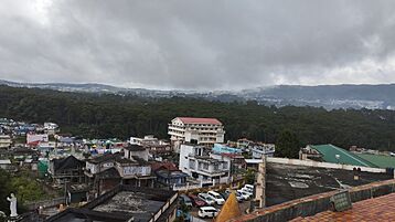
Shillong is a beautiful city located in the hills of Meghalaya, a state in northeastern India. It is the capital city of Meghalaya and the main town of the East Khasi Hills district. In 2011, about 143,229 people lived here.
The British, who ruled India for a long time, thought the rolling hills around Shillong looked like Scotland. Because of this, they often called it the "Scotland of the East."
Shillong started growing in 1864 when the British made it an important center for the Khasi and Jaintia Hills. In 1874, when Assam became a Chief Commissioner's Province, Shillong was chosen as its capital. This was because it was in a good spot between the Brahmaputra and Surma valleys. Also, its climate was much cooler than other parts of tropical India. Shillong remained the capital of Assam until 1972. On January 21, 1972, Meghalaya became a new state, and Shillong became its capital. Assam then moved its capital to Dispur in Guwahati.
Contents
- What's in a Name? The Meaning of Shillong
- A Look Back: Shillong's History
- Shillong's Location: Geography
- Getting Around: Transport in Shillong
- Who Lives Here? Demographics
- Fun Places to Visit: Places of Interest
- Sports in Shillong
- Learning in Shillong: Education
- News and Entertainment: Media
- Areas of Shillong: Neighbourhoods
- See also
What's in a Name? The Meaning of Shillong
Shillong gets its name from "U Blei Shyllong," who is a god of the Khasi people. Another popular story says that Shillong was named after a boy called "Aahlad." He was born to a virgin mother near a place called Bisi.
A Look Back: Shillong's History
Shillong was the capital of the larger state of Assam when the British ruled India. It stayed the capital even after India became independent, until the separate state of Meghalaya was formed.
In the early 1800s, a British officer named David Scott needed a road to connect Sylhet and Assam. This road had to go through the Khasi and Jaintia Hills. David Scott faced challenges from the local Khasi chiefs and their people. But he was very impressed by the cool weather in the Khasi Hills. In 1829, the British made a deal with the chief of Sohra to build a health resort for British people. This was the start of British influence in the Khasi-Jaintia Hills.
In 1829, the Khasi people started a big uprising against the British. Their leader, Tirot Sing, gave up in January 1833 and was taken to Dacca (now Dhaka). The British then placed a political officer in Sohra, also known as Cherrapunjee.
However, the British didn't like the weather or facilities in Sohra. So, they moved to Shillong. The biggest market in Shillong is called "Ïewduh." The name "Shillong" was chosen because the new town was built below the Shillong Peak.
In 1874, Shillong became the main administrative center for a new region. This region included Sylhet (now in Bangladesh), the Naga Hills (now Nagaland), and the Lushai Hills (now Mizoram), along with the Khasi, Jaintia, and Garo Hills. Shillong remained the capital of Assam until 1969. That's when Meghalaya became an independent state. In January 1972, Meghalaya became a full-fledged state.
The Shillong Municipal Board, which manages the city, started in 1878. It was set up to manage Shillong and its nearby villages.
A very strong earthquake happened on June 12, 1897. It had a magnitude of 8.1. This earthquake killed 27 people in Shillong and destroyed most of the town.
Shillong's Location: Geography

Shillong is located at 25°34′N 91°53′E / 25.57°N 91.88°E. It sits on the Shillong Plateau, which is a unique raised area in northern India. The city is in the middle of this plateau. It is surrounded by hills, and three of these hills are very important in Khasi traditions: Lum Sohpetbneng, Lum Diengiei, and Lum Shyllong.
Shillong is only about 100 km (62 mi) from Guwahati. You can reach it by road using NH 40. The journey takes about 2 hours and 30 minutes. You will see beautiful green hills and the Umiam lake along the way.
Shillong's Smart City Plan
Shillong was chosen as the 100th city to get money for the "Smart Cities Mission." This is a big government plan to make cities better. The plan aims to improve things like transport, water, and digital services. Each city chosen for this plan will get ₹ 5000 million from the government. This money helps them carry out different projects to become "smart cities."
Shillong's Weather: Climate
| Weather chart for Shillong | |||||||||||||||||||||||||||||||||||||||||||||||
|---|---|---|---|---|---|---|---|---|---|---|---|---|---|---|---|---|---|---|---|---|---|---|---|---|---|---|---|---|---|---|---|---|---|---|---|---|---|---|---|---|---|---|---|---|---|---|---|
| J | F | M | A | M | J | J | A | S | O | N | D | ||||||||||||||||||||||||||||||||||||
|
14
15
4
|
23
17
6
|
54
21
11
|
130
23
14
|
274
24
15
|
469
24
17
|
395
24
18
|
318
24
18
|
294
23
17
|
192
22
13
|
37
19
9
|
9.3
16
5
|
||||||||||||||||||||||||||||||||||||
| temperatures in °C precipitation totals in mm source: World Weather Information Service |
|||||||||||||||||||||||||||||||||||||||||||||||
|
Imperial conversion
|
|||||||||||||||||||||||||||||||||||||||||||||||
The weather in Shillong is usually very nice and clean. In summer, the temperature is around 23 °C (73 °F). In winter, it can get cooler, with temperatures around 4 °C (39 °F).
Shillong has a subtropical highland climate. This means its summers are cool and very rainy. Its winters are cool but dry. Shillong gets a lot of rain during the monsoon season. The monsoons usually start in June and continue to rain almost until the end of October.
| Climate data for Shillong (C.S.O) 1981–2010, extremes 1902–present | |||||||||||||
|---|---|---|---|---|---|---|---|---|---|---|---|---|---|
| Month | Jan | Feb | Mar | Apr | May | Jun | Jul | Aug | Sep | Oct | Nov | Dec | Year |
| Record high °C (°F) | 24.9 (76.8) |
26.1 (79.0) |
28.1 (82.6) |
30.2 (86.4) |
29.5 (85.1) |
29.5 (85.1) |
28.2 (82.8) |
28.4 (83.1) |
29.9 (85.8) |
27.8 (82.0) |
24.5 (76.1) |
22.5 (72.5) |
30.2 (86.4) |
| Mean daily maximum °C (°F) | 14.9 (58.8) |
17.0 (62.6) |
21.0 (69.8) |
23.2 (73.8) |
23.4 (74.1) |
24.0 (75.2) |
23.9 (75.0) |
24.1 (75.4) |
23.3 (73.9) |
21.6 (70.9) |
19.1 (66.4) |
16.0 (60.8) |
21.0 (69.8) |
| Mean daily minimum °C (°F) | 5.9 (42.6) |
7.5 (45.5) |
11.1 (52.0) |
13.8 (56.8) |
15.5 (59.9) |
17.4 (63.3) |
17.9 (64.2) |
17.7 (63.9) |
16.7 (62.1) |
14.3 (57.7) |
10.5 (50.9) |
7.2 (45.0) |
13.0 (55.4) |
| Record low °C (°F) | −0.9 (30.4) |
−2.4 (27.7) |
2.7 (36.9) |
6.6 (43.9) |
8.5 (47.3) |
10.0 (50.0) |
12.3 (54.1) |
10.0 (50.0) |
10.7 (51.3) |
6.7 (44.1) |
−0.5 (31.1) |
−3.3 (26.1) |
−3.3 (26.1) |
| Average rainfall mm (inches) | 13.6 (0.54) |
19.3 (0.76) |
46.0 (1.81) |
129.0 (5.08) |
266.6 (10.50) |
428.7 (16.88) |
496.5 (19.55) |
310.5 (12.22) |
276.6 (10.89) |
211.8 (8.34) |
38.8 (1.53) |
12.8 (0.50) |
2,250.4 (88.60) |
| Average rainy days | 1.6 | 2.3 | 4.1 | 9.7 | 15.8 | 18.1 | 17.9 | 16.7 | 15.7 | 8.4 | 2.1 | 1.1 | 113.5 |
| Average relative humidity (%) (at 17:30 IST) | 87 | 76 | 68 | 72 | 81 | 86 | 87 | 88 | 90 | 90 | 88 | 89 | 84 |
| Mean monthly sunshine hours | 223.2 | 223.2 | 232.5 | 219.0 | 170.5 | 108.0 | 99.2 | 108.5 | 102.0 | 176.7 | 216.0 | 235.6 | 2,114.4 |
| Mean daily sunshine hours | 7.2 | 7.9 | 7.5 | 7.3 | 5.5 | 3.6 | 3.2 | 3.5 | 3.4 | 5.7 | 7.2 | 7.6 | 5.8 |
| Source: India Meteorological Department (sun 1971–2000) | |||||||||||||
Getting Around: Transport in Shillong
Shillong is well connected by roads. However, it does not have its own train station or a big airport. The Umroi Airport is about 30 kilometres (19 mi) from the city center. It only has a few flights.
Roads for Travel

Shillong has good road connections to all the main states in Northeast India. Three important National Highways pass through the city:
- National Highway 6 (India) – This road connects Shillong to Guwahati, Tripura, and Mizoram.
- National Highway 106 (India) – This road connects to Nongstoin.
- National Highway 206 (India) – This road connects to Dawki.
Many private and state buses travel to and from Shillong every day. You can also find taxi services to places like Guwahati, Agartala, Kohima, Dimapur, and Aizawl.
The Shillong Bypass is a two-lane road. It is about 47.06 kilometres (29.2 mi) long. It connects Umiam (on NH-40) to Jorabat (on NH-44). From Jorabat, you can reach other northeastern states like Mizoram and Tripura. This road cost about ₹220 crore (US$37 million) to build and was finished between 2011 and 2013.
Flying to Shillong: Airways

Shillong is served by the Shillong Airport. It is located about 30 km away in Umroi. The airport has daily flights to and from Kolkata. There are also flights to and from other cities like Lilabari, Delhi, Silchar, Agartala, Imphal, Dimapur, and Dibrugarh. Airlines like Indigo, Alliance Air, and SpiceJet offer regular flights from this airport.
Train Connections: Railways
A new train line, the Teteliya-Byrnihat line, is being built. It will be about 22 km (14 mi) long. This line will connect Tetelia, a suburb of Guwahati, to Byrnihat, which is near Shillong. It is expected to be finished by March 2026. In the future, this line will be extended further to Shillong.
Who Lives Here? Demographics
According to the 2011 Census of India, Shillong had a total population of 143,229 people. There were 70,135 males and 73,094 females.
In terms of languages, 67,154 people in Shillong speak Khasi as their first language. About 28,984 speak Bengali, and 15,559 speak Hindi. Other languages spoken include Nepali, Assamese, Punjabi, Garo, and Urdu.
About 14,317 children in Shillong were aged 0 to 6 years. The overall literacy rate (meaning people who can read and write) was 83.5%. This means 119,642 people could read and write. For males, the literacy rate was 84.8%, and for females, it was 82.3%.

In 2011, Christianity was the main religion in Shillong, followed by 46.49% of the people. Hinduism was followed by 41.95%. Islam was followed by 4.89%. Smaller numbers of people followed Sikhism, Buddhism, and Jainism. An old local religion of the Khasi and Jaintia tribes is still followed by 4.5% of the people.
The larger Shillong metropolitan area includes several towns like Laitumkhrah and Mawlai. This area had a population of 354,759 people. About 12% of them were under six years old. The literacy rate in this metro area was 91%.
Fun Places to Visit: Places of Interest
Shillong has many interesting places to visit, both in and around the city:
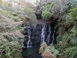
- Elephant Falls: This beautiful waterfall is about 12 km outside the city. The mountain stream flows down through three different falls. They are surrounded by rocks covered in ferns.
- Ka Phan Nonglait Park: This park is over a kilometer long. It also has a small zoo next to it.
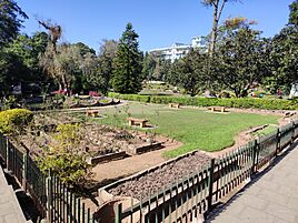
- Ward's Lake: Locals call this "Nan-Polok." It's a man-made lake with a lovely garden. You can also go boating here. It was built a long time ago when the British ruled.
- Shillong Golf Course: Shillong has one of Asia's largest natural golf courses. It's known as the "Gleneagles of the East." It's not just pretty, but also quite challenging! British officers started golf here in 1898 with a nine-hole course. The current 18-hole course opened in 1924. It's in a valley with pine and rhododendron trees.
- Motphran: This monument is called the "Monument of France." Locals know it as "Motphran." It was built to remember the 26th Khasi Labour Corps. These brave people served with the British in France during World War I. It has a Latin saying that means "It is sweet and honorable to die for one's country."
- Shillong Peak: This is a great spot for a picnic, about 10 km from the city. It's 1966 meters above sea level and offers amazing views of the countryside. It's the highest point in the state. Every spring, a religious priest honors U Shyllong at the peak's top.
- Capt. Williamson Sangma State Museum: If you're interested in tribal culture and traditions, this museum is for you. It shows how the local people live. It's located in the State Central Library complex.
- Don Bosco Centre for Indigenous Cultures: The Don Bosco Museum is part of this center. It's a place to learn about the cultures of Northeast India. It's located in Mawlai, Shillong.
- Wankhar Entomological Museum (Butterfly Museum): This is a private museum. It's the only known museum in India dedicated to moths and butterflies. It's about 2 km from Police Bazaar.
- Chrysalis the Gallery: This art gallery is in the Salonsar Mansion at Police Bazaar. Police Bazaar is a busy shopping area in Shillong. The gallery shows paintings, sculptures, photos, and handicrafts. It features artists from Northeast India and other parts of the country.
- State Museum: You can find this museum at the State Central Library complex.
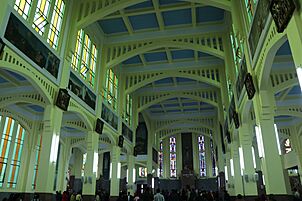
- Cathedral of Mary Help of Christians is located in Don Bosco Square.
- Bishop and Beadon Falls: These two waterfalls flow down the same steep cliff into a deep valley.
- Spread Eagle Falls: This waterfall is about 3 km from the polo grounds.
- Sweet Falls: Also called "Weitdem" by locals, this waterfall is about 5 km from Happy Valley. It is about 96 meters high.
- Crinoline Falls: This waterfall is near Phan Nonglait Park.
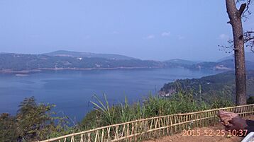
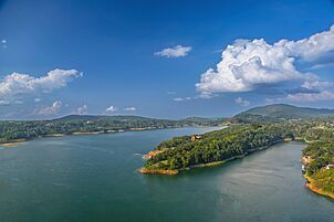
- Umiam Lake: You will see this beautiful lake on the way from Guwahati to Shillong.
-
Elephant Falls
-
Mary Help of Christians Cathedral
-

Umiam Lake
-
Lady Hydari Park
-
Shillong Barapani Lake
-
Shillong City view from Don Bosco Museum
-


Sports in Shillong

Shillong is one of the few capital cities in Northeast India that has three football clubs playing in the I-League. These clubs are Rangdajied United FC, Royal Wahingdoh FC, and Shillong Lajong FC. All three teams play their home games at the Jawaharlal Nehru Stadium, Shillong. Royal Wahingdoh FC finished second in the 2014–15 I-League season.
The Shillong Golf Course is one of the oldest golf courses in India. It is surrounded by beautiful pine and rhododendron trees.
Among the Khasi tribe of Meghalaya, archery has been a sport and a way to defend themselves for hundreds of years. It is also part of a local game called "teer." Shillong teer is a legal game that follows rules set by the Meghalaya government. The Khasi Hills Archery Sports Association manages this game.
Binningstar Lyngkhoi, from Shillong, is a national marathon runner. He represented India in the 2010 Commonwealth Games. He is one of the fastest marathon runners in India.
| Club | Sport | League | Stadium |
|---|---|---|---|
| Shillong Lajong FC | Football | I-League | Jawaharlal Nehru Stadium, Shillong |
| Rangdajied United F.C. | Football | I-League | Jawaharlal Nehru Stadium, Shillong |
| Ryntih FC | Football | I-League 2nd Division | Jawaharlal Nehru Stadium, Shillong |
Learning in Shillong: Education

Shillong has many important schools and colleges.
Specialized Institutions
- North Eastern Indira Gandhi Regional Institute of Health and Medical Sciences
- Indian Institute of Management Shillong
- National Institute of Technology Meghalaya
- National Institute of Fashion Technology Shillong
- North Eastern Institute of Ayurveda and Homeopathy
- Institute of Hotel Management
Colleges for Degrees
- Lady Keane College
- Raid Laban College
- St. Edmund's College
- Sankardev College
- Seng Khasi College
- Shillong College
- Shillong Commerce College
- Synod College
- Women's College, Shillong
Law Colleges
- Shillong Law College
- National Law University, Meghalaya
Universities
- English and Foreign Languages University
- North Eastern Hill University (NEHU)
- Indira Gandhi National Open University (IGNOU)
- Martin Luther Christian University
- William Carey University, Meghalaya
News and Entertainment: Media
Shillong has a lively media scene. There are many movie theaters, newspapers, magazines, and local radio and TV stations. Shillong is often called "India's Rock Capital" because people here love music so much. Many Western artists have performed concerts here.
Movies in Shillong: Cinema
You can watch movies at Bijou Cinema Hall, Gold Cinema, and Anjalee Cinema Hall (also known as Galleria Anjalee Cinema).
Reading the News: Print Media
Newspapers in Shillong are published in both Khasi and English. Some popular English newspapers are Shillong Times, Meghalaya Guardian, and Highland Post. Khasi newspapers include U Mawphor and U Nongsaiñ Hima. There are also magazines like "Iing Khristan" and "Youth Today."
TV and Radio: Electronic Media
The radio industry has grown a lot, with many private and government FM channels. The state-owned Doordarshan broadcasts TV channels. There are also local news channels like Peitngor Cable News (PCN) and Ri Khasi Channel, which are shown on local cable networks.
Staying Connected: Communication Services
You can get landline phones in Shillong. Internet services are available through both wired and wireless broadband. All the major mobile phone companies like Airtel, Vodafone Idea, BSNL, and Jio have good network coverage here.
Areas of Shillong: Neighbourhoods
Some of the well-known neighborhoods in Shillong include Mawkhar, Jaiaw, Riatsamthiah, Umsohsun, Wahingdoh, Khyndailad (Police Bazar), Mawlai, Laitumkhrah, Laban, Malki, Nongthymmai, and Polo.
See also
 In Spanish: Shillong para niños
