
Tripura facts for kids
Quick facts for kids
Tripura
|
||
|---|---|---|
    (clockwise from top) Clouded Leopard National Park; Rock-cut sculptures at Unakoti; Ujjayanta Palace; Neermahal palace
|
||
|
||
.svg) |
||

Map of Tripura
|
||
| Country | ||
| Union territory | 1 November 1956 | |
| State | 21 January 1972 | |
| Capital | Agartala | |
| Most populous city | Agartala | |
| Districts | 8 | |
| Government | ||
| Area | ||
| • Total | 10,491.65 km2 (4,050.85 sq mi) | |
| Area rank | 27th (2014) | |
| Population
(2011)
|
||
| • Total | 3,671,032 | |
| • Rank | 22nd (2014) | |
| • Density | 349.90035/km2 (906.2377/sq mi) | |
| Time zone | UTC+05:30 (IST) | |
| ISO 3166 code | IN-TR | |
| Vehicle registration | TR- | |
| HDI | ||
| HDI rank | 6th (2014) | |
| Literacy | 87.75 % (2011) | |
| Official languages | ||
| It was elevated from the status of Union-Territories by the North-Eastern Areas (Reorganisation) Act 1971 | ||

Tripura (Bengali: ত্রিপুরা) is a state located in Northeast India. It covers an area of about 10,491 square kilometers (4,036 square miles). This makes it the third smallest state in India. Tripura is bigger than the country of Lebanon but smaller than Kosovo. The capital city of Tripura is Agartala.
Contents
Tripura's Past
Tripura was once an independent kingdom. It was never directly ruled by the British in India. After its last king passed away, the kingdom joined the Republic of India. Some groups in Bangladesh have historically claimed parts of Tripura, saying it should be part of their territory. However, Tripura is now a state of India. It became a Union Territory on November 1, 1956, and then a full state on January 21, 1972.
Symbols of Tripura
Every state has special symbols that represent it. Tripura has its own unique provincial symbols:
-
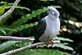
The Green Imperial Pigeon is the provincial bird of Tripura.
-
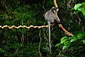
The Phayre's leaf monkey is the provincial animal of Tripura.
-
Agar is the provincial tree of Tripura.
-
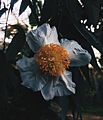
Cobra saffron, also called Nageshwar, is the provincial flower of Tripura.
-
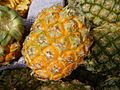
The Natal Queen pineapple is the provincial fruit of Tripura.

.jpg)


Life in Tripura
Tripura is known for its beautiful landscapes and rich culture. Many people in Tripura grow rice, which is the main crop. Rice fields cover about 91% of the land used for farming. The state has many narrow valleys called lungas, especially in the western parts, where rice grows well.
People and Culture
About 30% of Tripura's population are from the Tripuri ethnic group. They are a Tibeto-Burman group. They have a rich culture, including traditional dances. The main languages spoken in Tripura are Bengali, English, and Kokborok.
Festivals are an important part of life here. Durga Puja is a major festival celebrated in Tripura. You can also find beautiful temples like the Tripura Sundari Temple in Udaipur.
Education and Transport
Education is important in Tripura. In 2010–11, there were over 4,400 schools run by the government or private groups. Most teaching is done in English or Bengali.
Tripura has good transport links. Agartala airport connects the state by air. The Agartala Railway Station provides train services. There are also border posts, like the one in Akhaura, which connect Tripura with Bangladesh.
Images for kids
-
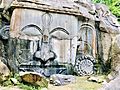
Rock-cut sculpture of Shiva at Unakoti.
-
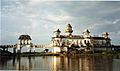
Neermahal Palace is a royal palace built by Bir Bikram Kishore Debbarman of the Kingdom of Tripura.
-
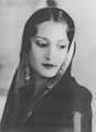
Queen Kanchan Prabha Devi signed the agreement for Tripura to join India.
-
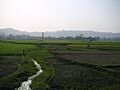
Rice is grown on Tripura's alluvial plains, including lungas (narrow valleys).
-
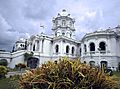
Ujjayanta Palace was built in the 19th century. It was used as the meeting place for Tripura's State Legislative Assembly until 2011.
-

Rice is the major crop in Tripura.
-
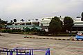
Agartala airport.
-
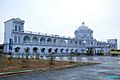
Agartala Railway Station.
-
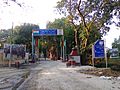
The border post between Bangladesh and India in Akhaura.
-
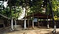
Classrooms built of bamboo in a school.
-
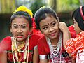
Tripuri children preparing for a dance performance.
-
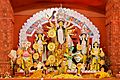
Durga Puja is the major festival of Tripura.
-
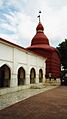
Tripura Sundari Temple in Udaipur.
-
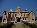
Universal Prayer Hall of Ramakrishna Mission in Agartala.


.JPG)

.JPG)


See also
 In Spanish: Tripura para niños
