
Kohima facts for kids
Quick facts for kids
Kohima
Kewhira
|
|
|---|---|
| City of Kohima | |
|
From top (left to right):
Kohima skyline with Kohima Village on top; Kohima street; PHQ Junction; Aradurah Hill |
|
| Motto(s):
"Work is Pride"
|
|

Kohima
Location in Nagaland

Kohima
Location in India
|
|
| Country | |
| Region | Northeast India |
| State | |
| District | Kohima District |
| Divisions | 19 municipal wards |
| Government | |
| • Type | Municipality |
| • Body | Kohima Municipal Council |
| Area | |
| • Total | 20 km2 (8 sq mi) |
| Elevation | 1,444 m (4,738 ft) |
| Population
(2011)
|
|
| • Total | 115,283 |
| • Density | 5,800/km2 (15,000/sq mi) |
| Demonym(s) | Kohimian kewhi–mia |
| Languages | |
| • Official | English |
| • Major languages | Angami • Ao • Chakhesang • Lotha • Sümi |
| Time zone | UTC+5:30 (IST) |
| PIN |
797001
|
| Telephone code | 91 (0)370 |
| Vehicle registration | NL-01 |
| Sex ratio | 927 ♂/♀ |
| Climate | Temperate (Köppen) |


Kohima is the capital city of Nagaland, a state in North East India. It is the second largest city in Nagaland, with nearly 100,000 people living there. Kohima is both a district and a municipality, covering about 20 square kilometers. The city is located at the foot of the Japfü section of the Barail Range and sits at an average height of 1,261 meters (4,137 feet) above sea level.
Originally, Kohima was known as Kewhira, a village of the Angami Naga people. It became an important town in 1878 when the British Empire set up its headquarters there. In 1963, when Nagaland became a state, Kohima was officially named its capital. Kohima was also the site of one of the most intense battles of World War II. This battle is sometimes called the Stalingrad of the East because of how fierce it was. In 2013, the British National Army Museum even called the Battle of Kohima Britain's Greatest Battle.
Contents
- Understanding the Name of Kohima
- A Look Back: Kohima's History
- Where is Kohima? (Geography)
- City Management and Services
- People of Kohima (Demographics)
- Kohima's Economy and Tourism
- Places to See in Kohima
- Culture and Events in Kohima
- Media and News
- Getting Around Kohima (Transportation)
- Learning in Kohima (Education)
- Sports and Fun
- Images for kids
- See also
Understanding the Name of Kohima
Kohima was first called Kewhi–ra. This name comes from the Angami word kephfükewhi, which means "to meet and assemble together." The word ra means "village." So, Kewhira means "the village where people meet." The people who originally lived in Kewhira are called Kewhimia, where mia means "people." They are the native owners of the land.
A Look Back: Kohima's History
Early Days of Kewhira Village
Stories passed down through generations say that a person named Tsiera (meaning "stone defender") founded Kewhira Village. The village is believed to be over 700 years old. It is also thought to be the second largest village in Asia. The village is divided into four main groups or clans: Tsütuonuomia, Lhisemia, Dapfhütsumia, and Pfüchatsumia.
British Influence in Kohima
The East India Company started to expand its control into the Kohima area in the 1840s. This was part of the British rule in India.
The Important Battle of Kohima

In 1944, during World War II, the Battle of Kohima was a major turning point in the Burma Campaign. At the same time, the Battle of Imphal was also happening. For the first time in Southeast Asia, the Japanese army lost its advantage to the Allied forces. This intense battle, fought hand-to-hand, stopped the Japanese Army from moving into the plains of India.
.jpeg)
Kohima has a large cemetery called the Kohima War Cemetery. It is a special place for Allied soldiers who died in the war. The Commonwealth War Graves Commission takes care of it. The cemetery is on Garrison Hill, where the Deputy Commissioner's tennis court used to be. This tennis court was a place of very heavy fighting, known as the Battle of the Tennis Court. A famous poem is carved on the memorial for the 2nd British Division in the cemetery:
When You Go Home, Tell Them of Us and Say,
For Your Tomorrow, We Gave Our Today.
This verse is believed to be by John Maxwell Edmonds. It was inspired by an old Greek poem honoring soldiers who died in the Battle of Thermopylae in 480 BC.
Kohima as State Capital (1963-Present)
On December 1, 1963, Nagaland became a full state of India. Kohima was chosen as its capital city.
Recent Events in Kohima
- 2017 Nagaland Protests: In February 2017, the office building of the Kohima Municipal Council was burned down by a crowd during protests against local elections. This fire also damaged nearby buildings.
- 2023 Kohima Fire: On February 27, 2023, a large fire broke out in Mao Market and NN Market. These were big shopping areas in Kohima, and the fire caused a lot of damage.
Where is Kohima? (Geography)
City Location and Landscape
Kohima is located in the southern part of Nagaland. It sits at 25°67' North latitude and 94°10' East longitude. The city is nestled between the Japfü–Barail mountains, with Pulie Badze hill to the southwest looking over the city.
Kohima's Climate
Kohima has a subtropical highland climate. This means it has mild temperatures, even though it's quite high up. The city experiences monsoons, which bring a lot of rain from June to September.
| Climate data for Kohima (1961–1990, extremes 1952–2012) | |||||||||||||
|---|---|---|---|---|---|---|---|---|---|---|---|---|---|
| Month | Jan | Feb | Mar | Apr | May | Jun | Jul | Aug | Sep | Oct | Nov | Dec | Year |
| Record high °C (°F) | 24.5 (76.1) |
25.0 (77.0) |
29.1 (84.4) |
32.2 (90.0) |
33.9 (93.0) |
30.5 (86.9) |
33.1 (91.6) |
31.1 (88.0) |
31.0 (87.8) |
31.5 (88.7) |
29.5 (85.1) |
26.0 (78.8) |
33.9 (93.0) |
| Mean daily maximum °C (°F) | 15.5 (59.9) |
17.7 (63.9) |
21.7 (71.1) |
23.8 (74.8) |
23.8 (74.8) |
24.7 (76.5) |
25.1 (77.2) |
25.3 (77.5) |
24.8 (76.6) |
23.7 (74.7) |
20.7 (69.3) |
17.9 (64.2) |
22.1 (71.8) |
| Daily mean °C (°F) | 11.6 (52.9) |
13.4 (56.1) |
17.3 (63.1) |
19.6 (67.3) |
20.4 (68.7) |
21.6 (70.9) |
21.5 (70.7) |
21.6 (70.9) |
21.3 (70.3) |
20.1 (68.2) |
16.6 (61.9) |
13.4 (56.1) |
18.2 (64.8) |
| Mean daily minimum °C (°F) | 8.0 (46.4) |
9.3 (48.7) |
11.2 (52.2) |
15.0 (59.0) |
16.6 (61.9) |
17.8 (64.0) |
18.7 (65.7) |
18.9 (66.0) |
17.9 (64.2) |
16.7 (62.1) |
13.1 (55.6) |
9.2 (48.6) |
14.5 (58.1) |
| Record low °C (°F) | 0.6 (33.1) |
2.3 (36.1) |
4.0 (39.2) |
5.0 (41.0) |
8.3 (46.9) |
9.4 (48.9) |
7.8 (46.0) |
8.3 (46.9) |
8.9 (48.0) |
5.0 (41.0) |
3.1 (37.6) |
2.2 (36.0) |
0.6 (33.1) |
| Average rainfall mm (inches) | 9.6 (0.38) |
24.0 (0.94) |
48.4 (1.91) |
92.2 (3.63) |
133.4 (5.25) |
323.6 (12.74) |
363.3 (14.30) |
360.7 (14.20) |
228.6 (9.00) |
134.8 (5.31) |
32.5 (1.28) |
5.8 (0.23) |
1,756.9 (69.17) |
| Average rainy days | 1.2 | 2.5 | 4.5 | 8.3 | 12.2 | 19.0 | 22.1 | 19.3 | 16.4 | 9.1 | 2.3 | 0.6 | 117.5 |
| Average relative humidity (%) | 74 | 67 | 65 | 70 | 77 | 85 | 88 | 88 | 86 | 83 | 76 | 71 | 78 |
| Source: India Meteorological Department | |||||||||||||
Kohima was ranked 36th among "National Clean Air Cities" in India for cities with populations under 300,000.
City Management and Services
Water Supply in Kohima
Many parts of Kohima face water shortages, especially during dry seasons. The current water sources, like the Zarü River and streams from Pulie Badze, are not enough for the city's growing population. New projects are planned to bring more water from places like Dzüko Valley.
How Kohima is Governed
The Kohima Municipal Council (KMC) was set up in 2005. It is responsible for things like managing waste, drainage, and issuing trade licenses. Other government departments also help manage the city. For example, the state's Urban Development Department created the "City Development Plan" for Kohima.
City Wards
Kohima is divided into nineteen main areas, which have a total of thirty-three smaller administrative wards. These wards are managed by the Kohima Municipal Council and cover about 35 square kilometers. Each ward has its own local council that handles many community services.
Keeping Kohima Safe
Police and Law Enforcement
The Kohima Police force is part of the Nagaland Police. Their job is to keep the peace and maintain order in the Kohima area. A Superintendent of Police (SP) leads the force. In 2020, the Kohima North Police Station became the first government facility in North East India to receive an International Organization for Standardization (ISO) 9001 Certification for its quality management system.
People of Kohima (Demographics)
Population Details
| Historical population | ||
|---|---|---|
| Year | Pop. | ±% |
| 1910 | 2,423 | — |
| 1920 | 2,790 | +15.1% |
| 1930 | 2,759 | −1.1% |
| 1940 | 3,507 | +27.1% |
| 1950 | 4,125 | +17.6% |
| 1960 | 7,246 | +75.7% |
| 1970 | 21,545 | +197.3% |
| 1980 | 34,340 | +59.4% |
| 1990 | 51,418 | +49.7% |
| 2000 | 77,030 | +49.8% |
| 2010 | 99,039 | +28.6% |
| Kohima Decadal Growth: | ||
In 2011, Kohima had a population of 99,039 people. There were more males (51,626) than females (47,413). The city has a high literacy rate of 90.76%, which is much higher than India's national average.
Religions in Kohima
The main religion in Kohima is Christianity, practiced by over 80% of the people. Other religions include Hinduism (16.09%), Islam (3.06%), and Buddhism (0.45%).
Kohima's Economy and Tourism

Tourism in Kohima
Tourism is a very important part of Kohima's economy. The number of visitors coming to the city has been growing a lot each year.
Places to See in Kohima
Historical Sites

- Kohima War Cemetery
The Kohima War Cemetery is a special memorial. It honors the soldiers of the 2nd British Division and other Allied forces who died in Kohima during World War II in April 1944. There are 1,420 graves of Commonwealth soldiers from the Second World War here.
Parks and Gardens
- Sakhrie Park
Sakhrie Park is a fun park located in the Middle Tsiepfü Tsiepfhe Ward. It is situated between Asian Highway 1 and Tsiepfü Tsiepfhe Road.
- Sokhriezie Park
Sokhriezie Park is a lake located in the center of the city, just below the PHQ Junction.
- Kohima Botanical Garden
The Kohima Botanical Garden is in New Ministers' Hill Ward. The Nagaland Forest Department takes care of this garden.
Culture and Events in Kohima
Cultural Centers
The Kohima Capital Cultural Center is a place with a large hall that offers many facilities for the city's residents. The Regional Centre of Excellence for Music & Performing Arts (RCEMPA) is a modern music and arts center located in Jotsoma, about 6 kilometers (3.7 miles) west of the city center.
Fun Events and Festivals

- NAJ Cosfest
The NAJ Cosfest is a cosplay festival for fans of Japanese pop culture (Otaku). It happens every July and started in 2013. It's one of the biggest cosplay festivals in North East India.
- Hornbill Festival
The Hornbill Festival is the largest annual festival in North East India. It takes place every year from December 1st to 10th. Its goal is to celebrate the rich heritage and traditions of the Naga people. The main events are held at the Kisama Heritage Village, which is about 12 kilometers (7.5 miles) south of the city center.
Fashion in Kohima
People in Kohima have always been known for being "fashion-conscious." There are many fashion stores throughout the city, and several fashion events are held every year. The southern parts of Kohima, starting from Main Town, are especially known for being trendy.
Museums to Visit
The Nagaland State Museum is located in Bayavü Hill. It has a wide collection of old sculptures, traditional clothes, and writings from the Naga people.
Religious Places

The Kohima Jain Temple was built in 1920. It is the oldest Jain temple in North East India.
Media and News
The most popular newspapers in Kohima are The Morung Express, Nagaland Post, Eastern Mirror, Nagaland Page, and the local newspaper Capi. Kohima was also home to Kewhira Dielie, which was the first modern newspaper published in Nagaland, but it is no longer in print.
The state-owned All India Radio has a local station in Kohima. It broadcasts various programs, including AIR FM Tragopan.
Getting Around Kohima (Transportation)
The main ways to get around Kohima are by bus and taxi.
Train Travel
Kohima does not have its own train station yet. The closest railway stations are the Chümoukedima Shokhüvi Railway Station and the Dimapur Railway Station. There are plans to extend the railway line from Dimapur to Kohima, and this project is expected to be finished by 2026.
Cycling in Kohima
Even though Kohima is very hilly, cycling has become a popular way to travel in and around the city. A system where people can share bicycles was started in September 2020.
Learning in Kohima (Education)
Sports and Fun
Naga Wrestling
Naga wrestling is very popular in Kohima. People from all over Nagaland come to watch the Naga Wrestling Championship, which happens every two years at the Khuochiezhie Local Ground in the heart of Kohima. The first Naga Wrestling Tournament was held in Kohima in 1971.
Images for kids
-
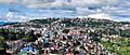
Kohima skyline with Kohima Village on top
-
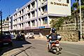
Kohima street
-
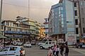
PHQ Junction
-
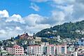
Aradurah Hill
See also
 In Spanish: Kohima para niños
