
Guwahati facts for kids
Quick facts for kids
Guwahati
Gauhati
|
|
|---|---|
| Guwahati City | |
|
Guwahati Aerial View
Guwahati Planetarium
Guwahati Ropeway Car
Guwahati Club Area
IIT Guwahati
Kamakhya Temple
|
|
| Nicknames:
Gateway to Northeast India, City of Temples, Light of the East
|
|

Guwahati
Location in Assam

Guwahati
Location in India

Guwahati
Location in Asia
|
|
| Country | |
| State | Assam |
| Region | Lower Assam |
| District | Kamrup Metropolitan district |
| Government | |
| • Type | Municipal Corporation |
| • Body | Guwahati Municipal Corporation |
| Area | |
| • Metropolis | 216 km2 (83 sq mi) |
| • Metro | 1,528 km2 (590 sq mi) |
| Elevation | 50-680 m (164-2,231 ft) |
| Population
(2011)
|
|
| • Metropolis | 957,352 |
| • Rank | 47th |
| • Density | 4,432/km2 (11,479/sq mi) |
| Demonym(s) | Guwahatian |
| Time zone | UTC+5:30 (IST) |
| PIN |
781 0xx
|
| Telephone code | +91 - (0) 361 |
| ISO 3166 code | IN-AS |
| Vehicle registration | AS-01 (Kamrup Metro) / AS-25 (Kamrup Rural and Dispur) |
| HDI | |
| Sex ratio | 940 ♀/ 1000 ♂ |
| City animal | Gangetic river Dolphin |
| GDP (2020–21) | ₹0.48 lakh crore (US$8.2 billion) |
| GDP per capita (2020–21) | ₹487,572 (US$8,300) |
| Climate | Cwa |
| Precipitation | 2,054 millimetres (80.9 in) |
| Official language | Assamese |
| Literacy | 91.47% |


Guwahati (Assamese: [ɡua.ɦa.ti]) is the largest city in the Indian state of Assam. It is also the biggest city in Northeast India. Dispur, the capital of Assam, is located within Guwahati. It is where the Government of Assam operates.
The Lokpriya Gopinath Bordoloi International Airport in Guwahati is one of the busiest airports in India. It is the busiest in the Northeast. Guwahati is a major river port city with hills. It is also one of the fastest-growing cities in India. The city sits on the south bank of the Brahmaputra River. People call Guwahati the "gateway to North East India."
Ancient cities like Pragjyotishpura and Durjaya (North Guwahati) were once capitals of the old state of Kamarupa. Many old Hindu temples are in the city. These include the Kamakhya Temple, Ugratara Temple, and Basistha Temple. This is why Guwahati is known as "The City of Temples." The famous Madan Kamdev temple is about 30 kilometres (19 miles) from Guwahati.
Guwahati is located between the Brahmaputra River and the foothills of the Shillong plateau. The LGB International Airport is to the west. The town of Narengi is to the east. The North Guwahati area, on the Brahmaputra's northern bank, is becoming part of the city. The Guwahati Municipal Corporation manages an area of 216 square kilometres (83 sq mi). The Guwahati Metropolitan Development Authority (GMDA) plans for the larger Guwahati Metropolitan Area. Guwahati is the largest city in Northeast India.
The Guwahati region is home to many different animals. These include rare ones like Asian elephants, pythons, tigers, rhinoceros, gaurs, and various types of monkeys. It also has endangered birds.
| Top - 0-9 A B C D E F G H I J K L M N O P Q R S T U V W X Y Z |
What's in a Name?
Guwahati gets its name from two Assamese words. "Guwa" (Assamese: গুৱা) comes from the Sanskrit word Guvaka. It means areca nut or its plant. "Hati" (Assamese: হাটী) means rows. So, Guwahati means "rows of areca nut trees."
A Look Back in Time
Ancient History of Guwahati
Old texts like the 10th-12th century Kalika Purana say that the Kamrup was home to strong people called Kirata. Legends from the Yogini Tantra tell us that the Dighalipukhuri lake in the city was dug by King Bhagadatta. He did this for his daughter Bhanumati's wedding to Duryodhan.
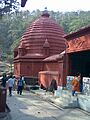
Guwahati has the Kamakhya Temple on Nilachal hill. This is an important place for certain spiritual practices. The ancient Navagraha Temple is on Chitrachal Hill. There are also old ruins in Basistha and other places important in myths.
Digs at Ambari show that Guwahati existed between 200 BCE and 100 CE. This was during the Shunga-Kushana period. Writings by Xuanzang (Hiuen Tsang) show that in the 7th century CE, during King Bhaskaravarman's rule, the city was about 15 km or 9.3 mi long. Finds at Ambari and during construction at Cotton College suggest the city was important for trade and strategy until the 9th-11th century CE.
Medieval History of Guwahati
Guwahati was the main office for the Borphukan. This was the Ahom governor of Lower Assam until 1824. The Borphukan lived in the area now called Fancy Bazaar. His meeting hall, called Dopdar, was about 270 meters west of the Bharalu stream. The Majindar Baruah, who was the Borphukan's personal secretary, lived where the deputy commissioner's residence is today.
During the Ahom kingdom, Guwahati was strongly protected. Many roads connected it to the rest of the country. The Dighalipukhuri lake was used for boats. From the time of King Gadadhar Singha, Ahom rulers built many temples in Guwahati.
Colonial History of Guwahati
When the British took over Assam in 1826, Guwahati became the center of British rule. It stayed this way until 1874. Then, the main office moved to Shillong in the Khasi hills.
Modern History of Guwahati
The Gauhati High Court started on March 1, 1948. It was set up by the Governor General of India, Lord Mountbatten. R.F. Lodge was the first Chief Justice.
The Saraighat Bridge connects Northeast India with the rest of the country. It was built between 1959 and 1962. The bridge was finished in September 1962. The first train crossed it on September 23, 1962.
In 1972, Meghalaya became a separate state from Assam. Because of this, Assam's capital moved from Shillong to Dispur. Dispur is a neighborhood in Guwahati. The first meeting of the Assam Legislative Assembly in Dispur was on March 16, 1973. Dispur is home to the Assam Government Secretariat and the Assam Assembly House.
Geography of Guwahati

The Brahmaputra river flows north of the city. The Shillong plateau foothills are to the south. The Amchang Wildlife Sanctuary is to the east. The Bharalu River, a branch of the Brahmaputra, flows through the city center.
To the southwest is Dipor Bil. This is a natural freshwater lake. It gets water from monsoon rains from the hills. The lake drains into the Brahmaputra, 5 km (3.1 mi) north. It helps store rainwater for the city. There are also many hills within the city limits.
How Guwahati is Built

Guwahati's city shape spreads out from its center. It grows towards the south, east, and west. In recent years, southern areas like Ganeshguri and Beltola have become new city centers. The old city center includes areas like Pan Bazaar and Fancy Bazaar. Each area has its own special activities.
The most important growth area is along the Guwahati-Shillong (GS) Road to the south. This road is about 15 km [9.3 mi] from the city center. The GS Road is a key business area with shops and offices. It also has many homes. The capital of Assam, Dispur, is in this area.
Another important area extends west. It is about 30 km [19 mi] from the city center. This area has a rail line that connects Guwahati to western Assam and the rest of India. It links important places like Nilachal Hill (Kamakhya) and Maligaon. There are also many river ports along this area.
The third main area extends east. It is about 15 km [9.3 mi] from the city center. This area connects Noonmati (Guwahati Refinery) and Narengi. It has seen a lot of housing growth. Highway NH-37 goes around the city's southern parts. It connects the southern and western areas. This highway is helping fast development.
Guwahati is one of 98 Indian cities chosen to become a Smart City. This is a project by the Indian government.
Climate of Guwahati
Guwahati has a humid subtropical climate. This means it has hot, humid summers and mild winters.
- Highest temperature ever: 40.6 °C (105.1 °F) on April 24, 2014.
- Lowest temperature ever: 3.0 °C (37.4 °F) on January 30, 1964.
| Climate data for Guwahati (Lokpriya Gopinath Bordoloi International Airport) (1991–2020, extremes 1951–present) | |||||||||||||
|---|---|---|---|---|---|---|---|---|---|---|---|---|---|
| Month | Jan | Feb | Mar | Apr | May | Jun | Jul | Aug | Sep | Oct | Nov | Dec | Year |
| Record high °C (°F) | 29.8 (85.6) |
35.7 (96.3) |
38.6 (101.5) |
40.6 (105.1) |
40.3 (104.5) |
39.0 (102.2) |
38.4 (101.1) |
39.2 (102.6) |
38.0 (100.4) |
37.0 (98.6) |
33.4 (92.1) |
30.9 (87.6) |
40.6 (105.1) |
| Mean daily maximum °C (°F) | 23.9 (75.0) |
27.0 (80.6) |
30.5 (86.9) |
31.2 (88.2) |
31.8 (89.2) |
32.6 (90.7) |
32.8 (91.0) |
33.2 (91.8) |
32.5 (90.5) |
31.3 (88.3) |
28.5 (83.3) |
25.4 (77.7) |
30.0 (86.0) |
| Daily mean °C (°F) | 17.4 (63.3) |
20.0 (68.0) |
23.5 (74.3) |
25.7 (78.3) |
27.3 (81.1) |
28.7 (83.7) |
29.3 (84.7) |
29.5 (85.1) |
28.6 (83.5) |
26.7 (80.1) |
22.8 (73.0) |
19.0 (66.2) |
24.9 (76.8) |
| Mean daily minimum °C (°F) | 10.8 (51.4) |
13.0 (55.4) |
16.5 (61.7) |
20.3 (68.5) |
22.9 (73.2) |
25.2 (77.4) |
25.9 (78.6) |
25.8 (78.4) |
24.9 (76.8) |
22.3 (72.1) |
17.2 (63.0) |
12.6 (54.7) |
19.7 (67.5) |
| Record low °C (°F) | 3.0 (37.4) |
5.3 (41.5) |
8.5 (47.3) |
10.3 (50.5) |
16.4 (61.5) |
20.4 (68.7) |
20.6 (69.1) |
20.8 (69.4) |
19.9 (67.8) |
13.8 (56.8) |
10.0 (50.0) |
4.9 (40.8) |
3.0 (37.4) |
| Average rainfall mm (inches) | 11.5 (0.45) |
18.0 (0.71) |
52.5 (2.07) |
182.1 (7.17) |
253.0 (9.96) |
314.0 (12.36) |
283.4 (11.16) |
264.3 (10.41) |
184.5 (7.26) |
117.9 (4.64) |
9.6 (0.38) |
4.6 (0.18) |
1,695.3 (66.74) |
| Average precipitation days (≥ 0.3 mm) | 2.1 | 3.2 | 5.7 | 15.2 | 18.7 | 20 | 21.2 | 18.2 | 14.4 | 7.4 | 1.8 | 1.2 | 129.1 |
| Average rainy days | 1.1 | 1.9 | 4.4 | 10.6 | 14.2 | 14.6 | 15.2 | 12.3 | 9.7 | 4.8 | 0.7 | 0.5 | 90.0 |
| Average relative humidity (%) | 72 | 59 | 51 | 62 | 71 | 78 | 80 | 81 | 82 | 79 | 77 | 76 | 72 |
| Mean monthly sunshine hours | 225.5 | 213.8 | 220.1 | 200.6 | 191.1 | 133.1 | 123.7 | 161.6 | 139.0 | 205.8 | 230.9 | 231.7 | 2,276.9 |
| Source 1: India Meteorological Department (1991-2020) | |||||||||||||
| Source 2: NOAA (sun 1971–1990, precipitation days) Tokyo Climate Center (mean temperatures 1991–2020) | |||||||||||||
Guwahati was ranked 36th best "National Clean Air City" in India in 2023. This was for cities with 3-10 lakh people.
City Life and Services

Guwahati offers a good quality of life. A 2006 survey ranked it 17th among large and medium Indian cities. The city has nice landscapes, a pleasant climate, and modern shopping areas. It also has modern homes and good community services. A four-lane East-West Corridor is being built. It will pass through Guwahati and connect all state capitals in Northeast India. This project is expected to help the whole region grow.

The city is working to improve its services. The Asian Development Bank is helping to improve Guwahati's transport. The Jawaharlal Nehru National Urban Renewal Mission (JNNURM) also provides funds for development.
How Guwahati is Governed

Dispur, the capital of Assam, is in Guwahati. In 1972, the Government of Assam decided to move its capital to Dispur. This happened after Meghalaya became a separate state. Dispur is home to the Assam Government Secretariat and the Assam Assembly House. It also has important offices like the National Bank for Agriculture and Rural Development (NABARD).
The Guwahati Municipal Corporation is in charge of managing the city. It is divided into 60 areas called municipal wards. The Guwahati Metropolitan Development Authority (GMDA) plans for the larger Guwahati area. It aims to cover 3,214 square kilometres (1,241 sq mi) by 2025.
Guwahati has four assembly areas: Jalukbari, Dispur, Gauhati East, and Gauhati West. All of these are part of the Gauhati Lok Sabha area.
Police in Guwahati
Guwahati is the main office for the Assam Police. The city's police force is led by the Commissioner of Police. It is split into three police districts: East, Central, and West. Each district has a Deputy Commissioner of Police.
Courts in Guwahati

Guwahati is where the main Gauhati High Court is located. This court serves Assam, Nagaland, Mizoram, and Arunachal Pradesh. The Gauhati High Court started on April 5, 1948. It moved to Guwahati on August 14, 1948.
Guwahati also has the Court of the District and Sessions Judge, Kamrup. This court was set up in 1920. It handles cases for the greater Guwahati area.
Challenges Facing Guwahati
Growing Population
Guwahati's population has grown quickly in recent years. Many people move here for school and jobs. This growth has caused the city to expand. It has also led to problems like more slum areas. Experts think Guwahati's population will reach 1.5 million by 2035. It was about 1.1 million in 2020.
Rising Prices
People in Guwahati face rising prices for many basic goods. This includes vegetables, chicken, and fish. Prices often go up very fast. Vegetables come from other states like West Bengal and Bihar. Truckers pay fees at check posts, which adds to the cost. Local vegetables also become more expensive due to transport costs.
The price of chicken from places like Chaygaon has also gone up. Fish prices have increased too. The COVID-19 pandemic made these price increases even worse.
Flooding Issues
Experts believe that city flooding in Guwahati will get worse. Some areas might even become unlivable. Since the early 2000s, changes to drainage systems and wetlands have made flooding worse. This is due to fast city growth.
Professor Abani Kumar Bhagawati of Gauhati University explained that in the past, wetlands absorbed rainwater. Channels carried extra water to the Brahmaputra. But human activity has changed the natural landscape. Now, "just half an hour of rain" can cause floods. Buildings and paved areas reduce open spaces where water can soak in. This is a main cause of floods.
Pollution Concerns
In a 2023 report by IQAir, Guwahati was ranked the second most polluted city in the world. It was behind Begusarai and ahead of Delhi. This shows that India has high levels of pollution.
People of Guwahati
| Historical Guwahati city population | ||
|---|---|---|
| Year | Pop. | ±% |
| 1951 | 45,000 | — |
| 1961 | 138,000 | +206.7% |
| 1971 | 203,000 | +47.1% |
| 1981 | 348,000 | +71.4% |
| 1991 | 591,000 | +69.8% |
| 2001 | 818,809 | +38.5% |
| 2011 | 962,334 | +17.5% |
| 2021 | 1,135,000 | +17.9% |
| Source: Guwahati city historical demography | ||
| Religions in Guwahati (2011) | ||||
|---|---|---|---|---|
| Religion | Percent | |||
| Hinduism | 84.74% | |||
| Islam | 12.45% | |||
| Jainism | 0.96% | |||
| Christianity | 0.93% | |||
| Other or not stated | 0.92% | |||
Population Growth
Guwahati is one of the fastest-growing cities in India. In 2011, Guwahati had a population of 962,334. The population in 2021 was estimated to be around 1.1 million. It is thought that the Guwahati metro area will have 2.8 million residents by 2025.
Education and Gender Balance
In 2011, children aged 0-14 made up 9.40% of Guwahati's population. The average literacy rate was 91.47%. This means most people can read and write. For males, it was 94.24%, and for females, it was 88.50%. The sex ratio was 933 females for every 1,000 males. For children, it was 940 girls for every 1,000 boys.
Languages Spoken
According to the 2011 census, about 57.80% of people in Guwahati spoke Assamese. About 20.40% spoke Bengali. Other languages included Hindi (12.29%), Nepali (1.92%), and Boro (1.69%).
Education in Guwahati


Guwahati is a major education center in Northeast India. One important school is the Indian Institute of Technology Guwahati (IIT). It is a top school for technical studies. Cotton University, which used to be Cotton College, is another old and respected school for Science and Arts.
Major Educational Institutions
- Gauhati University
- Cotton University
- Srimanta Sankaradeva University of Health Sciences
- Assam Science and Technology University
- Indian Institute of Technology, Guwahati
- Indian Institute of Information Technology, Guwahati
- Gauhati Medical College and Hospital
- Assam Engineering College
- Assam Don Bosco University
- Royal Global University
- Tata Institute of Social Sciences (Guwahati Campus)
- National Institute of Pharmaceutical Education and Research, Guwahati
Private Schools
- Don Bosco School
- Delhi Public School
- Sanskriti the Gurukul
- Holy Child School
- St. Mary's English High School
Economy and Business
Pandu is an old area on the Brahmaputra River. It was once a military base for the Ahoms. Because it was well-protected, it became a natural river port. Pandu port is part of the Dhubri-Sadiya National Waterway-2. It is an important place for moving goods, cargo, and people. New docks have been built to handle container ships. This has helped the city's income.

Making things is a big part of Guwahati's economy. Oil refining is a very important industry. The Guwahati Refinery is the most important factory in the city. It is located at Noonmati. This refinery was the first public sector refinery in India. It started in 1962. It makes products like cooking gas (LPG), kerosene, and jet fuel. These products are sent to other Northeast states and beyond. There is also an LPG bottling plant in the city.
Tea making and processing is another key activity. Assam is one of the world's largest tea producers. It makes 80% of India's tea for export. The Guwahati Tea Auction Centre (GTAC) is near Dispur. It is the world's largest auction center for CTC tea. The first sale happened on September 25, 1970. In August 2019, a kilogram of special tea sold for a record ₹ 70,501 at the GTAC.
Many banks, both government and private, have branches in Guwahati. The Reserve Bank of India also has an office here.
Getting Around Guwahati

By Air
Guwahati is served by the Lokpriya Gopinath Bordoloi International Airport. It is in Borjhar, about 20 kilometres (12 mi) west of the city center. This airport is the tenth busiest in India for passenger traffic. Many airlines fly to and from Guwahati. You can find daily and weekly flights to major Indian cities and international places like Bangkok. A new airport building is being built and is expected to be finished by 2025.
By Train

The city of Guwahati is part of the Northeast Frontier Railway (NFR) Zone. Its main office is in Maligaon. The Guwahati railway station is in Paltan Bazaar. It is the busiest train station in the city.
There are four other train stations in Guwahati. These include Kamakhya Junction for passengers and cargo. New Guwahati railway station is only for cargo. There are also Narangi railway station and Azara railway station. Regular trains connect Guwahati to other big cities in India. Some important trains are Rajdhani Express and Vande Bharat. The Vivek Express, India's longest train route, passes through Guwahati.
By Road


Guwahati has 218 km (135 mi) of paved roads. National Highway 27 connects Guwahati to states like West Bengal and the rest of India. This highway also links Guwahati to Silchar in Assam and other Northeast states. National Highway 17 connects Guwahati with cities like Dhubri. National Highway 15 runs along the Brahmaputra River. It connects Guwahati to cities in Upper Assam and states like Arunachal Pradesh.
Public transport is well developed. Buses are the main way to get around. The state-owned Assam State Urban Transport Corporation and private companies offer bus services. The Rupnath Brahma Inter State Bus Terminus (ISBT) is a major bus station. It has regular bus services to other parts of Assam and Northeast India.
A metro rail project is also planned. This will help reduce traffic on the roads. Cycling has also become more popular in the city. Guwahati is one of the few Indian cities with a Bicycle Mayor. The Guwahati-Panchgram Expressway, the first expressway in Northeast India, was announced in February 2025. It will cut travel time between Guwahati and Panchgram by 5 hours.
By Water
The Inland Water Transport Department has its main office at Pandu Port in Guwahati. This is the largest river port in Assam. Water transport services in Guwahati are used for moving large amounts of goods and cargo. They also carry passengers and tourists. Ferry services are available to transport people from different ports along the Brahmaputra to Pandu port.
Sports in Guwahati


Guwahati has the multi-purpose Nehru Stadium. It hosts mostly football and cricket games. It is part of the R.G. Baruah Sports Complex, one of the oldest in the city. This complex also has an indoor stadium for badminton, a swimming pool, and tennis courts. Other important sports places include the North-East Frontier Railway Stadium and the Judges Field.
New sports facilities were built for the 33rd National Games in 2007. These include the Indira Gandhi Athletic Stadium at Sarusajai Sports Complex. This stadium was also the main venue for the 2016 South Asian Games and the Himalayan Region Games in 2017.
Guwahati is home to NorthEast United FC, a professional football club in the Indian Super League (ISL). They play their home games at the Indira Gandhi Athletic Stadium. This stadium also hosted matches for the 2017 FIFA U-17 World Cup in 2017.
The international cricket stadium, Assam Cricket Association Stadium at Barsapara, is home to the Assam cricket team. It is the largest cricket stadium in Northeast India. It can hold 40,000 people. It hosted an India vs Australia T20I match in 2017. The first One Day International (ODI) match there was in 2018.
| Club | Sport | League | Stadium | Established |
|---|---|---|---|---|
| NorthEast United FC | Football | Indian Super League | Indira Gandhi Athletic Stadium | 2014 |
| Northeastern Warriors | Badminton | Premier Badminton League | Karmabir Nabin Chandra Bordoloi Indoor Stadium | 2017 |
| Assam Titans Futsal Club | Futsal | North East Futsal League | Karmabir Nabin Chandra Bordoloi Indoor Stadium | N.A. |
Media and Communication

Many daily newspapers are published in Guwahati. Assamese newspapers include Dainik Agradoot and Asomiya Pratidin. English newspapers are The Assam Tribune and The Sentinel. Eclectic Northeast is a monthly magazine from Guwahati. G Plus is the only English weekly newspaper.
The state-owned TV channel DD Assam offers free satellite TV. Guwahati also has 24-hour regional news channels like News Live and Pratidin Time.
The Guwahati Radio Station of All India Radio started on July 1, 1948. It moved to Guwahati in 1953. It has three channels. Other FM radio stations include 92.7 BIG FM and Red FM 93.5. Phone services are provided by companies like BSNL, Airtel, and Jio.
Famous Places of Worship
- Temples in Guwahati
-
Basistha Temple, rebuilt by Ahom King Rajeswar Singha in 1764 CE.
-

Doul Govinda Temple.
-
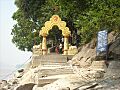
Umananda Temple, built by King Gadadhar Singha in 1694 CE on the world's smallest river island.
-
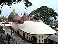
Kamakhya Temple, the oldest among the Shakti pethas, located on Nilachal hills.


- Kamakhya Temple
- Rudreswar Temple
- Doul Govinda Temple
- Ugratara Devalaya
- Basistha Temple
- Sukreswar Temple
- Lankeshwar Temple
- Dirgheshwari temple
- Umananda Temple
- Navagraha temples
Famous People from Guwahati
- Nabakanta Barua, a poet and teacher
- Dipankar Bhattacharjee, an Indian badminton player
- Barsha Rani Bishaya, an Assamese film actor
- Zubeen Garg, a singer and actor
- Arnab Goswami, a journalist
- Mamoni Raisom Goswami, a novelist and teacher
- Bhupen Hazarika, a famous singer
- Himanta Biswa Sarma, the current Chief Minister of Assam
- Shiva Thapa, a boxer
See also
 In Spanish: Guwahati para niños
- Assam State Museum
- Saraighat Bridge
- List of colleges affiliated to Gauhati University
- List of people from Western Assam
- Silchar
- Jorhat
- Tezpur
- Dibrugarh
- Bongaigaon
