
Aizawl facts for kids
Quick facts for kids
Aizawl
Aijal
|
|
|---|---|
|
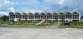
Clockwise from top: aerial view of Aizawl at night, Solomon's Temple, AR Ground Stadium, terminal of Lengpui Airport, Aizawl Theological College, Aizawl at day
|
|
| Nickname(s): | |

Aizawl
Location in Mizoram

Aizawl
Location in India

Aizawl
Location in Asia
|
|
| Country | |
| State | Mizoram |
| District | Aizawl |
| Government | |
| • Body | Aizawl Municipal Corporation |
| Area | |
| • Total | 129.91 km2 (50.16 sq mi) |
| Elevation | 1,132 m (3,714 ft) |
| Population
(2024)
|
|
| • Total | 405,000 |
| • Rank | 1st in Mizoram |
| • Density | 2,253/km2 (5,840/sq mi) |
| Languages | |
| • Official | Mizo and English |
| • Additional Spoken | other Kukish languages, Nepali. |
| Time zone | UTC+5:30 (IST) |
| PIN |
796001
|
| Telephone code | 0389 |
| Vehicle registration | MZ-01 |
| Sex ratio | 1025 females per 1000 males ♂/♀ |
| Climate | Cwa |
| Literacy | 98.36% |


Aizawl (pronounced like "eye-zole"), also known as Aijal in the past, is the capital city of Mizoram, India. It is the biggest city in Mizoram and one of the largest in northeast India. Aizawl sits on top of several ridges, about 1,132 meters (3,714 feet) above sea level. In 2024, about 405,000 people live here.
Contents
What does "Aizawl" mean?
The name Aizawl comes from two Mizo words: "ai" which means "cardamom" (a spice) and "zawl" which means "flatland" or "plain." So, "Aizawl" can be thought of as "the field of cardamom." This name might tell us something about what the area was like before it became a city.
Aizawl's Story
Early Days (before 1889)
In 1871–72, a Mizo Chief named Kalkhama caused some trouble. This led the British to set up a small outpost. This outpost grew into what we now know as Aizawl village. It was a good spot because it was close to a stream and easy to reach by boat.
British Rule (1889-1948)
In 1889, a British officer named Dally came to Aizawl with 400 men to help with a military operation. Dally suggested that Aizawl would be a good place for a strong military post. So, Colonel Skinner built a fort there. This fort, called Fort Aijal, was officially opened on February 25, 1890. It became the main center for British rule in the North Lushai Hills.
Aizawl quickly became important for the Mizo people, not just for government but also for religion, after the Welsh Mission Society set up its main office there. More people moved to Aizawl, and its market became the biggest trading spot in the Lushai Hills.
Modern Aizawl (1948-today)
Capital of Mizo District (1948-1972)
Aizawl, which was once a small village on a flat hilltop, started to grow very fast. In the late 1950s, many people moved to Aizawl because of a severe famine called Mautam. They were looking for food and jobs. Soon, nearby villages like Chaltlang and Durtlang became part of the growing city. By the early 1960s, Aizawl had become a modern city.
The 1966 Uprising
In the mid-1960s, Aizawl's growth slowed down because of a conflict called the Mizo Independence Movement. This movement was led by the Mizo National Front (MNF), which was fighting against the Government of India.
A very sad event happened in Aizawl in March 1966. To stop the MNF, the Government of India used airplanes to bomb Aizawl and nearby areas. Many people had already left the city and gone into the jungle to be safe. This was the first time the Indian government used airstrikes in its own urban areas.
Capital of Mizoram Union Territory (1972-1987)
Aizawl remained the capital when Mizoram became a Union Territory. This new status helped Aizawl grow economically. The city became a major place for business and trade. Many Burmese Chin immigrants also came to Aizawl looking for better jobs.
Capital of Mizoram State (1987-today)

When Mizoram became a full state, Aizawl got more help and money from the central government. This allowed the city to build new things like Lengpui Airport. It also helped improve schools, hospitals, and programs to help people, making life better for everyone in Aizawl.
Where is Aizawl?
Aizawl is located north of the Tropic of Cancer in the northern part of Mizoram. It sits on a ridge that is 1,132 meters (3,715 feet) above sea level. To its west is the Tlawng river valley, and to its east is the Tuirial river valley.
How Aizawl is Governed

The Aizawl Municipal Corporation (AMC) is in charge of running Aizawl city. It was started in 2010 and has 19 members. These members are elected from 19 different areas (wards) of the city. The AMC also has a chairman, a vice-chairman, and three executive members. About one-third of the seats are saved for women, and these seats change every five years. The AMC council serves for five years. Each ward also has a committee with an elected councilor as chairman and two members from each local council in that ward. There are 78 local councils, and they also serve for five years.
People of Aizawl
| Religion in Aizawl City (2011) | ||||
|---|---|---|---|---|
| Religion | Percentage | |||
| Christianity | 93.63% | |||
| Hinduism | 4.14% | |||
| Islam | 1.52% | |||
| Buddhism | 0.45% | |||
| Not Stated | 0.11% | |||
| Others | 0.09% | |||
| Sikhism | 0.03% | |||
| Jainism | 0.02% | |||
In 1910, there were 777 army personnel in Aizawl from different parts of North India and Nepal. Some of the Gurkha soldiers eventually made Aizawl their home.
According to the 2011 Census of India, Aizawl had a population of 293,416 people. Slightly more than half (50.61%) were females, and the rest (49.39%) were males. Most of the people in Aizawl are Mizos from different tribes. The main religion in the city is Christianity, with about 93.63% of the people being Christian. Other religions include Hinduism (4.14%), Islam (1.52%), and Buddhism (0.45%).
Aizawl's Weather
Aizawl has a mild, sub-tropical climate because of where it is located and its high elevation. This means it has a humid subtropical climate (Cwa). In summer, temperatures are warm, usually between 20 and 30 degrees Celsius. In winter, daytime temperatures are cooler, usually between 11 and 21 degrees Celsius.
| Climate data for Aizawl, elevation 950 m (3,120 ft), (1991–2020, extremes 1973–2010) | |||||||||||||
|---|---|---|---|---|---|---|---|---|---|---|---|---|---|
| Month | Jan | Feb | Mar | Apr | May | Jun | Jul | Aug | Sep | Oct | Nov | Dec | Year |
| Record high °C (°F) | 29.5 (85.1) |
33.8 (92.8) |
34.6 (94.3) |
35.5 (95.9) |
34.2 (93.6) |
33.6 (92.5) |
33.2 (91.8) |
32.2 (90.0) |
32.7 (90.9) |
33.1 (91.6) |
32.8 (91.0) |
28.5 (83.3) |
35.5 (95.9) |
| Mean daily maximum °C (°F) | 23.3 (73.9) |
24.8 (76.6) |
28.1 (82.6) |
28.8 (83.8) |
28.0 (82.4) |
27.2 (81.0) |
27.0 (80.6) |
27.5 (81.5) |
27.3 (81.1) |
27.2 (81.0) |
26.0 (78.8) |
23.8 (74.8) |
26.6 (79.9) |
| Mean daily minimum °C (°F) | 11.3 (52.3) |
13.0 (55.4) |
16.4 (61.5) |
17.5 (63.5) |
18.7 (65.7) |
19.5 (67.1) |
20.2 (68.4) |
20.1 (68.2) |
19.6 (67.3) |
19.1 (66.4) |
15.9 (60.6) |
12.6 (54.7) |
16.9 (62.4) |
| Record low °C (°F) | 6.1 (43.0) |
7.3 (45.1) |
9.6 (49.3) |
11.7 (53.1) |
12.2 (54.0) |
15.2 (59.4) |
12.0 (53.6) |
16.2 (61.2) |
16.7 (62.1) |
13.5 (56.3) |
10.0 (50.0) |
8.0 (46.4) |
6.1 (43.0) |
| Average rainfall mm (inches) | 9.1 (0.36) |
19.4 (0.76) |
71.5 (2.81) |
134.2 (5.28) |
322.5 (12.70) |
311.0 (12.24) |
326.6 (12.86) |
342.2 (13.47) |
337.9 (13.30) |
173.0 (6.81) |
42.5 (1.67) |
10.6 (0.42) |
2,100.5 (82.70) |
| Average rainy days | 0.8 | 1.7 | 3.9 | 7.9 | 14.1 | 17.3 | 18.9 | 18.7 | 15.3 | 10.0 | 2.2 | 0.7 | 111.5 |
| Source: India Meteorological Department | |||||||||||||
| Weather chart for Aizawl | |||||||||||||||||||||||||||||||||||||||||||||||
|---|---|---|---|---|---|---|---|---|---|---|---|---|---|---|---|---|---|---|---|---|---|---|---|---|---|---|---|---|---|---|---|---|---|---|---|---|---|---|---|---|---|---|---|---|---|---|---|
| J | F | M | A | M | J | J | A | S | O | N | D | ||||||||||||||||||||||||||||||||||||
|
13
20
11
|
23
22
13
|
73
25
16
|
168
27
18
|
289
26
18
|
406
26
19
|
320
25
19
|
321
26
19
|
305
26
19
|
184
25
18
|
43
23
15
|
15
21
12
|
||||||||||||||||||||||||||||||||||||
| temperatures in °C precipitation totals in mm source: WMO |
|||||||||||||||||||||||||||||||||||||||||||||||
|
Imperial conversion
|
|||||||||||||||||||||||||||||||||||||||||||||||
Getting Around Aizawl
By Air
Aizawl has an airport called Lengpui Airport, which is close to the city. You can fly from here to cities like Kolkata, Delhi, Guwahati, Agartala, Shillong, and Imphal. Different airlines like Air India, Go First, and IndiGo fly these routes. There's also a helicopter service that started in 2012, connecting Aizawl to other towns in Mizoram.
By Rail
Mizoram is connected to India's railway network up to a place called Bairabi. The government is also building a new, wider railway line called the Bairabi Sairang Railway to make it easier to travel within the state.
There was a plan for an Aizawl Monorail system in 2011, but it's still not clear if it will be built.
News and Media
Newspapers: You can find many newspapers in Aizawl, published in both Mizo and English languages. Some popular ones are:
- Vanglaini
- The Zozam Times
- The Aizawl Post
- India Today NE
- Khawpui Aw
- Virthli
- The Mizoram Post
- Zoram Tlangau
- Mizo Arsi
- Zalen
- Zawlaidi
- Zozam Weekly
- Zoram Thlirtu
- Sakeibaknei
- Entlang
Radio: All India Radio has a studio in Aizawl that broadcasts programs. FM Zoawi is also a popular radio station in the city.
Learning in Aizawl

Colleges and Universities
Pachhunga University College was one of the first colleges, started in 1958. Aizawl College is the second oldest, founded in 1975. Hrangbana College, established in 1980, has many students studying business and arts.
Mizoram University, started in 2001, is a big university that all colleges in Mizoram are connected to. It offers advanced degrees and engineering courses. Other colleges like ICFAI University, Mizoram, Aizawl West College, Government Aizawl North College, and J. Thankima College also offer undergraduate courses. If you want to study law, there's Mizoram Law College. New institutions like the Indian Institute of Mass Communication and National Institute of Technology Mizoram have also opened. Zoram Medical College was opened on August 7, 2018.
Sports in Aizawl

Football is the most loved sport in Mizoram. Many footballers from here play in national leagues across India. Aizawl has its own professional football club, Aizawl F.C., which plays in the I-League. Here are some important sports places in Aizawl:
- Rajiv Gandhi Stadium can hold 20,000 people and is in Mualpui.
- Hawla Indoor Stadium is the biggest indoor stadium. It has facilities for basketball, badminton, and boxing.
- Lammual stadium is a single-level stadium that will soon be able to seat about 5,000 people.
Here are some of the sports teams from Aizawl:
| Team | Sport | League | Venue |
|---|---|---|---|
| Mizoram football team | Football | Santosh Trophy | Rajiv Gandhi Stadium |
| Aizawl F.C. | Football | I-League | Rajiv Gandhi Stadium |
| Chanmari F.C. | Football | Mizoram Premier League | Lammual |
| Chawnpui F.C. | Football | Mizoram Premier League | Lammual/Vaivakawn field |
Aizawl also hosted a big event for youth groups called the Xchange North East Youth NGO summit from October 3 to 5, 2018.
See also
In Spanish: Aizawl para niños
Images for kids
-
Lengpui Airport
