
Pabna District facts for kids
Quick facts for kids
Pabna
পাবনা
|
|
|---|---|
| Motto(s):
"২১ এর চেতনায়,আলোকিত পাবনা!"
|
|

Location of Pabna in Bangladesh
|
|
| Country | |
| Division | Rajshahi Division |
| Pubna District,Bengal Presidency,British India | 1828 |
| Area | |
| • Total | 2,371.50 km2 (915.64 sq mi) |
| flood plain and marsh land | |
| Elevation | 8 m (26 ft) |
| Population
(2019 census)
|
|
| • Total | 3,011,180 |
| • Density | 1,269.736/km2 (3,288.602/sq mi) |
| Literacy rate | |
| • Total | 85% |
| Time zone | UTC+06:00 (BST) |
| Postal code |
6600–6682
|
Pabna District (Bengali: পাবনা জেলা Pabna Zila) is a district in central Bangladesh. It is a very important district in the country. The main town and administrative center is also called Pabna.
History of Pabna
Some experts, like the archeologist Cunningham, thought the name Pabna might come from an old civilization called Pundra. Their capital, Mahasthangarh, was the oldest city in Bangladesh. However, not everyone agrees with this idea.
Between 1859 and 1861, Pabna was a key area during the Indigo revolt. This was a protest by farmers against British indigo planters.
Later, around 1873, farmers in the Yusufshahi area started to resist. They were unhappy because their landlords, called zamindars, were demanding too much rent. These farmers formed a group called the Agrarian League. This movement was mostly peaceful.
The Lieutenant-Governor of Bengal, George Campbell, supported the farmers. He was against the landlords who lived far away. These protests are often called the Pabna disturbances.
The next year, a severe famine hit the district. Finally, in 1885, a new law called the Rent Law Act was passed. This law helped meet some of the farmers' demands.
In 1875, an area called Raaygonj was moved back to Pabna from Bogra. Then, in 1879, a special court system was created for both Pabna and Bogra districts. The history of Pabna was written by a lawyer named Chowdhury Mohammad Badruduzza.
Geography of Pabna
Pabna is located in the southeast part of the Rajshahi Division. To its northeast is Sirajganj District. The Padma River, which is the main part of the holy Ganges river, forms its southern border. This river separates Pabna from Rajbari District and Kushtia District.
The Jamuna River runs along Pabna's eastern side, separating it from Manikganj District. To the northwest, Pabna shares a border with Natore District.
The average highest temperature in Pabna is about 36.8 °C, and the lowest is around 9.6 °C. The area gets about 1872 mm of rain each year.
The soil in Pabna is mainly of four types. These include the flood plains of the Ganges, Karatoya, and Jamuna rivers, as well as the Barind Tract. The main rivers flowing through Pabna are the Ganges, Ichamati, Gumani, Baral, and Hurasagar.
Images for kids
-
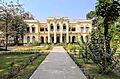
Tarash Palace
-
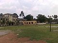
Pabna Zilla School


See also
 In Spanish: Pabna (zila) para niños
