Rajbari District facts for kids
Quick facts for kids
Rajbari
রাজবাড়ি জেলা
|
|
|---|---|

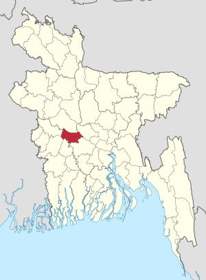
Location of Rajbari in Bangladesh
|
|
| Country | |
| Division | Dhaka Division |
| Area | |
| • Total | 1,118.8 km2 (432.0 sq mi) |
| Population
(2011 census)
|
|
| • Total | 1,049,778 |
| • Density | 938.31/km2 (2,430.20/sq mi) |
| Literacy rate | |
| • Total | 39.81% |
| Time zone | UTC+6 (BST) |
| • Summer (DST) | UTC+7 (BDST) |
Rajbari (Bengali: রাজবাড়ি জেলা, Rajbari Jela or Rajbari Zila) is a district in central Bangladesh. It is a part of the Dhaka Division. A district is like a large area or region within a country. Rajbari was created as a district in 1984.
Contents
About Rajbari District
Rajbari District is located in the middle part of Bangladesh. It is known for its important position in the country. The district is part of the larger Dhaka Division. This division is one of the main administrative areas of Bangladesh.
Where is Rajbari Located?
Rajbari is found in the central region of Bangladesh. It is situated at about 23.70 degrees North latitude and 89.50 degrees East longitude. This location places it in a key area for travel and trade. The district covers an area of about 1,118.8 square kilometers.
What is a District?
In Bangladesh, a district is an important administrative unit. It helps to organize the country into smaller, manageable parts. Each district has its own local government. This government helps to manage services for the people living there. Rajbari is one of these important districts.
Quick Facts About Rajbari
According to the 2011 census, Rajbari District has a population of over 1 million people. To be exact, there were 1,049,778 residents. The people of Rajbari are known as Rajbari people. The literacy rate in the district is about 39.81%. This means that almost 40 out of every 100 people can read and write.
See also

- In Spanish: Rajbari (zila) para niños
 | Shirley Ann Jackson |
 | Garett Morgan |
 | J. Ernest Wilkins Jr. |
 | Elijah McCoy |

