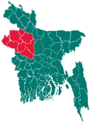
Rajshahi Division facts for kids
Quick facts for kids
Rajshahi Division
রাজশাহী বিভাগ
|
|
|---|---|

Map of Rajshahi Division
|
|
| Country | |
| Area | |
| • Total | 18,174.4 km2 (7,017.2 sq mi) |
| Population
(2011 census)
|
|
| • Total | 18,329,000 |
| • Density | 1,008.506/km2 (2,612.02/sq mi) |
| Time zone | UTC+6 (BST) |
Rajshahi Division is one of the eight main administrative areas in Bangladesh. It is like a big region or state within the country. In 2011, about 18.3 million people lived here.
This division covers an area of about 18,174 square kilometers. It has many smaller parts, including 16 districts and 128 Upazilas. Upazilas are like sub-districts. It also has 1,092 Unions, which are the smallest local government units.
The main city in this division is Rajshahi. It is a busy place and an important center for the region. You can travel from Rajshahi city to Dhaka, the capital of Bangladesh, in about four hours by road. Rajshahi Division has good roads and railway lines, making it easy to travel around.
Where is Rajshahi Division?
Rajshahi Division is located in the northwest part of Bangladesh. It shares its borders with other important places.
- To the south, the famous Padma River flows, forming a natural boundary.
- On its eastern side, another well-known river, the Jamuna, runs.
- To the north and west, Rajshahi Division shares a border with India. This means it's close to another country.
Being located near these rivers and borders makes Rajshahi Division an important area for trade and travel.
Want to Learn More?
- In Spanish: División de Rajshahi para niños
 | Ernest Everett Just |
 | Mary Jackson |
 | Emmett Chappelle |
 | Marie Maynard Daly |

