
Sundarbans facts for kids
Quick facts for kids Sundarbans |
|
|---|---|

Sundarbans
Location in South Asia
|
|
| Location | |
| Nearest city | |
| Area | 10,277 km2 (3,968 sq mi)10,277 km2 (3,968 sq mi) |
| Governing body | |
The Sundarbans is a huge mangrove forest area. It is found where the Ganges, Brahmaputra, and Meghna Rivers meet the Bay of Bengal. This special forest stretches from the Hooghly River in India to the Baleswar River in Bangladesh. It has many types of mangrove forests, mudflats, and open lands. Many tidal streams and channels cut through it.
The Sundarbans is the world's largest mangrove forest, covering about 10,277 square kilometers. A big part of it (over 6,017 square kilometers) is in Bangladesh. The rest (about 4,260 square kilometers) is in India.
Four parts of the Sundarbans are recognized as UNESCO World Heritage Sites. These include Sundarbans West, Sundarbans South, and Sundarbans East in Bangladesh, and Sundarbans National Park in India. This amazing forest is home to 453 types of wildlife. This includes 290 kinds of birds, 120 fish, 42 mammals, 35 reptiles, and 8 amphibians.
However, the Sundarbans faces many threats. Strong storms like Cyclone Sidr in 2007 and Cyclone Aila in 2009 have caused a lot of damage. Rising sea levels and less fresh water also make the water saltier, which harms the trees. Experts are working to restore mangroves and help people adapt to these changes.
Contents
- What's in a Name? The Sundarbans' Meaning
- A Look Back: The History of Sundarbans
- Where in the World? The Geography of Sundarbans
- How the Land is Formed: The Sundarbans' Unique Landscape
- Different Worlds Within: Sundarbans Ecoregions
- Amazing Plants: The Flora of Sundarbans
- Incredible Animals: The Fauna and Life Cycle in Sundarbans
- Endangered and Extinct Species in Sundarbans
- Climate Change Impact on Sundarbans
- Hazards to the Sundarbans
- Economy and Life in Sundarbans
- Administration of Sundarbans
- Protected Areas of Sundarbans
- Images for kids
- See also
What's in a Name? The Sundarbans' Meaning
The name Sundarbans (pronounced Soon-dar-bons) means "beautiful forest" in Bengali. Some people think the name might come from "Sea Forest" (Samudraban) or from a tribe called Chandra-bandhe. But most likely, it comes from the Sundari tree (Heritiera fomes). This tree is very common in the area.
A Look Back: The History of Sundarbans
People have lived in the Sundarbans area for a very long time, even since the Maurya Empire (around 4th to 2nd century BCE). Old city ruins have been found here. During the Mughal Empire, local rulers allowed people to settle in parts of the forest.
In 1757, the British East India Company took control of the Sundarbans. They mapped the area in 1764. But serious efforts to manage and protect the forest began much later. The first group to manage the Sundarbans forests was set up in 1869. By 1875, a large part of the mangrove forests became protected areas under a special law. This helped to keep the forest safe.
Where in the World? The Geography of Sundarbans
The Sundarbans forest is located in a huge delta on the Bay of Bengal. This delta is formed by the Hooghly, Padma (parts of the Ganges), Brahmaputra, and Meghna rivers in southern Bangladesh. The forest covers about 10,277 square kilometers. About 6,517 square kilometers are in Bangladesh, and 4,260 square kilometers are in India. A large part of the Indian Sundarbans (about 1,700 square kilometers) is made up of rivers, canals, and creeks.
This area has many tidal waterways, mudflats, and small islands. These islands are covered with salt-tolerant mangrove forests. The network of waterways means you can reach almost any part of the forest by boat.
The Sundarbans is famous for the Bengal tiger. It is also home to many other animals like birds, chital deer, crocodiles, and snakes. The fertile soil here has been used by humans for centuries. Many areas have been turned into farms. However, the remaining forests, especially the mangroves, are very important for the endangered tiger.
Mangrove trees also act like a natural shield. They protect millions of people in cities like Kolkata and Khulna from floods caused by cyclones. They also help prevent tsunamis and soil erosion along the coast.
How the Land is Formed: The Sundarbans' Unique Landscape
The mangrove-dominated Ganges Delta – the Sundarbans – is a complex ecosystem. It is one of the three largest mangrove forests in the world. Most of it is in Bangladesh, with a smaller part in India. To the south, it meets the Bay of Bengal. To the east, it borders the Baleswar River. To the north, it meets farmlands.
The Sundarbans was much larger about 200 years ago, covering around 16,700 square kilometers. Today, it is about one-third of its original size. The land area is now about 4,143 square kilometers, including sandbars. The remaining 1,874 square kilometers are rivers, streams, and canals. The rivers here mix salt water from the Bay of Bengal with fresh water from the Ganges. This creates a special environment.
The land in the Sundarbans has been shaped over thousands of years by river sediments and tides. It has many drainage lines, tidal flats, and small islands. The ground level is usually between 0.9 and 2.11 meters above sea level.
The mangrove plants and animals play a big role in shaping the coast. They create different habitats like beaches, estuaries, swamps, and tidal flats. The mangrove trees help create new land. Their roots trap sediments, which helps new mangrove seeds grow. The mudflats are exposed during low tide and covered during high tide. This means the landscape changes every day! The inner parts of the mudflats are perfect for mangroves to grow.
Different Worlds Within: Sundarbans Ecoregions
The Sundarbans features two main ecoregions. These are the "Sundarbans freshwater swamp forests" and the "Sundarbans mangroves." Each has its own special features.
Sundarbans Freshwater Swamp Forests
These are tropical moist broadleaf forests found in Bangladesh and India. They are located behind the main mangrove areas. Here, the water is only slightly salty. It becomes very fresh during the rainy season. This happens when fresh water from the Ganges and Brahmaputra rivers pushes out the salt water. These forests cover about 14,600 square kilometers.
Sadly, these forests are greatly threatened. Many areas have been cleared for farming and human settlements. This has caused a big loss of habitats and different kinds of plants and animals. Only a few protected areas remain. Some important trees here include Heritiera minor and Excoecaria agallocha.
Sundarbans Mangroves

The Sundarbans Mangroves are found along the coast. They form the largest mangrove ecosystem in the world, covering about 20,400 square kilometers. The most common mangrove tree here is Heritiera fomes, known locally as sundri or sundari.
Mangrove forests do not have a huge variety of plants. They have a thick canopy, and the ground mostly has young mangrove trees. Besides the sundari, other trees include Avicennia, Xylocarpus mekongensis, and Nypa fruticans palms.
The Sundarbans is home to 26 of the 50 main mangrove species found globally. These forests are different from other coastal mangroves. They have unique types of salt water mixed forests, mangrove scrub, and brackish water forests.
How New Land Grows: Ecological Succession in Sundarbans
Ecological succession is like nature's way of building new land. It describes how different plant communities grow in an area over time. In the Sundarbans, when new mudflats are formed by river deposits, certain plants are the first to grow. These "pioneer" plants are often Sonneratia, followed by Avicennia and Nypa palms.
As more soil is deposited, the land gets higher. Then, other trees start to appear. Excoecaria is a common tree that shows up later. When the land gets even higher and is only flooded by tides sometimes, the Heritiera fomes tree begins to grow. This process shows how the Sundarbans constantly changes and grows.
Amazing Plants: The Flora of Sundarbans


In 1903, a scientist named David Prain recorded 334 plant species in the Sundarbans. Unlike many other mangrove areas, the Sundarbans has a lot of plants from the Malvaceae and Euphorbiaceae families.
The most common plants here are sundari (Heritiera fomes), gewa (Excoecaria agallocha), goran (Ceriops decandra), and keora (Sonneratia apetala). The sundari tree is so important that the forest might even be named after it! Its hard wood is used for building houses, boats, and furniture.
Keora trees often grow on newly formed mudbanks. They are also a very important food source for wildlife, especially spotted deer. You can also find dhundul (Xylocarpus granatum) and kankra (Bruguiera gymnorhiza) trees. Among palms, golpata (Nypa fruticans) is common. Grasses like spear grass and khagra also grow here.
The Sundarbans has many types of forests. These include mangrove scrub, littoral forest, saltwater mixed forest, and swamp forest. There are also large areas of marshes, intertidal mudflats, and sandy areas with special plants. The types of plants found here depends on how salty the water is and how much fresh water flows in.
Incredible Animals: The Fauna and Life Cycle in Sundarbans
The Sundarbans is a special place for many animals. It is a rich wildlife habitat.
According to recent counts (2015 in Bangladesh and 2011 in India), there are about 180 Bengal tigers in the Sundarbans. This includes 106 in Bangladesh and 74 in India. These counts use special camera traps to get accurate numbers. Tigers are powerful predators and can be dangerous to humans who enter their habitat.
Mangroves are a bridge between the ocean, fresh water, and land. They provide a vital home for many small fish, crabs, shrimps, and other creatures. These animals adapt to live, feed, and reproduce among the tangled roots of the mangroves. These roots, called pneumatophores, grow upwards from the mud to get oxygen.
A study in 1991 showed that the Indian Sundarbans alone supports many animals. This includes at least 150 types of important fish, 270 bird species, 42 mammal species, 35 reptile species, and 8 amphibian species. Many of these species are now rare or gone from other parts of the country. Some endangered species include two amphibians, 14 reptiles, 25 birds, and five mammals. The Sundarbans is also a key place for migratory birds in winter.
Protecting wildlife here means stopping poaching (illegal hunting) and creating wildlife sanctuaries. In these sanctuaries, animals can live with fewer disturbances. Even though wildlife numbers have decreased over time, the mangrove forest still has many important habitats and animals. The tiger and dolphin are key animals for wildlife management and tourism. Their health shows how well the overall wildlife is doing. Some species are protected by law.
Mammals of the Sundarbans


The Sundarbans is a very important home for the Bengal tiger (Panthera tigris). It also provides a home for smaller wild cats. These include the jungle cat (Felis chaus), fishing cat (Prionailurus viverrinus), and leopard cat (P. bengalensis).
Many predators live in the maze of channels and roots. The Bengal tiger is the largest land predator in this region. Unlike tigers in other places, these tigers live and swim among the mangrove islands. They hunt animals like chital deer (Axis axis), Indian muntjacs, wild boar, and Rhesus macaque monkeys. It is thought that there are about 180 Bengal tigers and 30,000 spotted deer in the area.
Endangered and Extinct Species in Sundarbans


Studies of the forest show that the numbers of two main mangrove trees, sundari (Heritiera spp.) and gewa (Excoecaria agallocha), decreased by 40% and 45% between 1959 and 1983. Even with a ban on hunting most wildlife, many animal and plant species have become fewer in number or have disappeared in the 20th century. This means the natural health of the forest is declining.
Endangered species living in the Sundarbans today include the Bengal tiger, estuarine crocodile, northern river terrapin, olive ridley sea turtle, Gangetic dolphin, ground turtles, hawksbill sea turtles, and king crabs. The Sundarbans is also very important for the critically endangered masked finfoot. It is a key winter home for the spoon-billed sandpiper and the Indian skimmer.
Some animals that used to live here are now gone. These include the Indian hog deer, water buffalos, barasingha (swamp deer), Javan rhinoceros, Indian rhinoceros, and the mugger crocodile. These animals disappeared by the mid-20th century due to past hunting activities. Other threatened mammals include the capped langur, smooth-coated otter, Asian small-clawed otter, and large Indian civet.
Climate Change Impact on Sundarbans


The coast of the Sundarbans is constantly changing due to waves, tides, and currents. These forces cause erosion and new land to form. The mangrove plants help keep the whole system stable. During the monsoon season, almost all of the Bengal Delta is flooded, often for half the year.
One of the biggest challenges for people living in the Ganges Delta is the threat of rising sea levels. This is partly due to climate change. In many mangrove wetlands in Bangladesh, the amount of fresh water reaching the mangroves has decreased since the 1970s. This is because of water being used upstream by India. This makes the water saltier in some areas.
A 2007 report by UNESCO warned that a 45-centimeter rise in sea level, combined with other human impacts, could destroy 75% of the Sundarbans mangroves. Already, some islands like Lohachara Island and New Moore Island have disappeared under the sea. Ghoramara Island is now half submerged.
A 2012 study found that the Sundarbans coast was shrinking by up to 200 meters each year. Farming activities destroyed about 17,179 hectares of mangroves between 1975 and 2010. Shrimp farming destroyed another 7,554 hectares.
Researchers in 2010 estimated that the sea level was rising by 8 millimeters each year. This was double the rate recorded in 2000. Rising sea levels have also submerged about 7,500 hectares of forest. Along with warmer water temperatures and increased saltiness, this threatens the plants and animals. The Sundari trees, for example, are very sensitive to salt and are at risk.
Mangroves help protect coastal areas from cyclones and tsunamis. So, keeping them healthy is very important. The worsening storms and tidal surges linked to climate change have caused people to move away from the coast. About 13% of residents relocated between 2000 and 2010.
Hazards to the Sundarbans
Natural Hazards
A report by UNESCO stated that Cyclone Sidr in 2007 damaged about 40% of the Sundarbans.
Human-Made Hazards
In August 2010, an agreement was made to build the Rampal power station, a coal-fired plant. This project was planned for an area over 1,834 acres, about 14 kilometers north of the Sundarbans. Environmental groups raised concerns that this project could harm the unique mangrove forest.
On December 9, 2014, an oil tanker carrying 358,000 liters of furnace oil sank in the Sela river in the Sundarbans after hitting another vessel. The oil spread over 350 square kilometers, affecting a second river and many canals. This event was very dangerous for trees, tiny organisms, fish, and dolphins. It happened in a protected mangrove area, home to rare Irrawaddy and Ganges dolphins. Local residents and authorities worked to clean up the oil. Some reports indicated that wildlife was harmed, including a dead Irrawaddy dolphin found floating in the river.
Economy and Life in Sundarbans


The Sundarbans forest is very important for protection and providing resources. It makes up 51% of Bangladesh's total reserve forest. It also provides about 41% of the country's forest income and about 45% of all timber and firewood.
Agriculture in Sundarbans

Some parts of the Sundarbans are protected from tidal floods. Here, you can find villages and farms. During the monsoon season, the low-lying farmlands are flooded. So, farmers mainly grow deepwater rice. In the dry winter, the land is often used for grazing cattle. Near villages, ponds filled during the monsoon are used to water vegetable crops. Some farms and mangrove areas are also being cleared for aquaculture (fish and shrimp farming).
Human Habitation
The Sundarbans area has a population of over 4 million people.
Administration of Sundarbans

The West Bengal government has approved a new district in South 24 Parganas, which was named Sundarban.
Protected Areas of Sundarbans

The Bangladesh part of the forest is managed by two forest divisions and four administrative ranges. These include Chandpai, Sarankhola, and Burigoalini. It has sixteen forest stations. There are also three wildlife sanctuaries, created in 1977. The West Bengal part of the forest is in the South and North 24 Parganas districts.
Protected areas cover 15% of the Sundarbans mangroves. These include Sundarbans National Park and Sajnakhali Wildlife Sanctuary in West Bengal. In Bangladesh, there are Sundarbans East, Sundarbans South, and Sundarbans West Wildlife Sanctuaries.
In May 2019, local authorities in Bangladesh stopped 4 tiger poachers in the Sundarbans. At that time, about 114 tigers lived there.
Sundarban National Park
The Sundarban National Park is a National Park, Tiger Reserve, and a Biosphere Reserve in West Bengal, India. It is part of the Sundarbans delta and is next to the Sundarbans Reserve Forest in Bangladesh. The delta is covered with dense mangrove forests. It is one of the largest homes for the Bengal tiger. It also has many birds, reptiles, and invertebrates, including the salt-water crocodile. The current Sundarbans National Park became the main area of the Sundarbans Tiger Reserve in 1973 and a wildlife sanctuary in 1977. It was declared a National Park on May 4, 1984.
Sundarbans West Wildlife Sanctuary
Sundarbans West Wildlife Sanctuary is a UNESCO World Heritage Site in Bangladesh. This area has mangroves, including scattered Gewa (Excoecaria agallocha) and dense Goran (Ceriops tagal). You can also find patches of Hantal palm (Phoenix paludosa) on drier ground and river banks. The sanctuary has many different animals, with about 40 mammal species, 260 bird species, and 35 reptile species. The most famous is the Bengal tiger, with an estimated 350 living in the Bangladesh Sundarbans. Other large mammals include wild boar, chital deer, Indian otter, and macaque monkey. Five types of sea turtles visit the coast. Two endangered reptiles here are the estuarine crocodile and the Indian python.
Sundarbans East Wildlife Sanctuary
Sundarbans East Wildlife Sanctuary covers an area of 31,227 hectares in Bangladesh. Sundari trees (Heritiera fomes) are the most common plants. They are mixed with Gewa (Excoecaria agallocha) and Passur (Xylocarpus mekongensis). Kankra (Bruguiera gymnorhiza) grows in areas that flood more often. There are also smaller plants like Shingra (Cynometra ramiflora) in drier soils and Amur (Aglaia cucullata) in wetter areas. Goran (Ceriops decandra) grows in saltier places. Nypa palm (Nypa fruticans) is common along the water channels.
Sundarbans South Wildlife Sanctuary
Sundarbans South Wildlife Sanctuary covers an area of 36,970 hectares in Bangladesh. This area has the biggest changes in saltiness throughout the year. It likely has moderate salt levels for longer periods. Here, Gewa (Excoecaria agallocha) is the main woody plant. It is often mixed with Sundri trees. It is also frequently found with a dense layer of Goran (Ceriops tagal) and sometimes Passur.
Sajnakhali Wildlife Sanctuary
Sajnakhali Wildlife Sanctuary is a 362 square kilometer area in the northern part of the Sundarbans delta in West Bengal, India. It mainly consists of mangrove scrub, forest, and swamp. It was set up as a sanctuary in 1976. It is home to many different kinds of wildlife. These include water fowl, herons, pelicans, spotted deer, rhesus macaques, wild boar, tigers, water monitor lizards, fishing cats, otters, olive ridley turtles, crocodiles, batagur terrapins, and migratory birds.
Images for kids
-
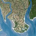
SPOT satellite image of Sundarbans, released by CNES
-

Landsat 7 image of Sundarbans, released by NASA Earth Observatory
-
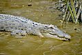
A saltwater crocodile on a river bank in the Sundarbans


See also
 In Spanish: Sundarbans para niños
- Sundarbans Tiger Project
- Mangroves in India
- Indian Council of Forestry Research and Education
- Sangu Wildlife Sanctuary
- Environmental impact of development in the Sundarbans
- Tiger attacks in the Sundarbans
