
Barisal Division facts for kids
Quick facts for kids
Barisal Division
বরিশাল বিভাগ
Bakerganj
|
|
|---|---|

Barisal Division in Bangladesh
|
|
| Country | |
| Established | 1797 (as Bakerganj District) |
| Capital | Barisal city |
| Area | |
| • Total | 13,225.20 km2 (5,106.28 sq mi) |
| Population
(2011 census)
|
|
| • Total | 8,325,666 |
| • Density | 629.53044/km2 (1,630.4764/sq mi) |
| Time zone | UTC+6 (BST) |
| ISO 3166 code | BD-A |
| Districts | 6 |
| Sub-Districts | 41 |
| Union Councils | 352 |
| Website | barisaldiv.gov.bd |
Barisal (also spelled Barisāl) is a large area in south-central Bangladesh. Think of a division like a big region or state within a country. It's one of six main divisions in Bangladesh today. Long ago, this area was known as Bakerganj. Before Bangladesh became an independent country, Barisal was a district in a place called East Pakistan. The main town of Barisal was once managed by the Roychoudhury family. They later moved to Calcutta.
Contents
History
How Barisal Became a Division
Barisal has an interesting past! A long time ago, in 1797, this area was first set up as a district. It was called Bakerganj District. Later, its name was changed to Barisal District. This happened during the time when the British ruled the area.
Fun Places to Visit
Barisal Division has some cool spots to explore!
- Kuakata beach is the most popular place for tourists. It's one of only two beaches in South Asia where you can see both the sunrise and the sunset over the sea. How cool is that?
- Durga Sagor is another beautiful dighi (which means a large pond or lake). Many birds fly here from far away to spend the winter. It's a great place for birdwatching!
- Barisal Division has 42 upazilas in total. An upazila is like a sub-district, a smaller area within a district. The newest ones are Rangabali in Patuakhali and Taltoli in Barguna.
How Barisal is Organized
Barisal Division is divided into smaller parts to help manage everything. It has six main areas called districts (or zilas). These districts are then split into 39 even smaller areas called sub-districts (or upazilas).
Even smaller than that, there are:
- 353 union parishads (which are like local councils)
- 3,159 mouzas (which are groups of villages)
- 12 municipalities (towns with their own local government)
- 25 wards (smaller parts of a municipality)
- 4,163 villages
Here's a quick look at the districts in Barisal Division:
| Name | Capital | Area (km²) | Population
(2011) |
|---|---|---|---|
| Barisal District | Barisal | 2,784.52 | 2,324,310 |
| Barguna District | Barguna | 1,831.31 | 892,781 |
| Bhola District | Bhola | 3,403.48 | 1,776,795 |
| Jhalokati District | Jhalokati | 706.76 | 682,669 |
| Patuakhali District | Patuakhali | 3,221.31 | 1,535,854 |
| Pirojpur District | Pirojpur | 1,277.80 | 1,113,257 |
| Total Division | Barisal | 13,255.20 | 8,325,666 |
Images for kids
-
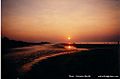
Sunrise at Kuakata sea beach, Barisal
-
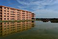
Academic buildings of the University of Barisal
-
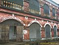
Brojomohun College, established in 1889


See also
 In Spanish: División de Barisal para niños
