
Bhola District facts for kids
Quick facts for kids
Bhola
|
|
|---|---|

Location of Bhola in Bangladesh
|
|
| Country | |
| Division | Barisal Division |
| Area | |
| • Total | 3,403.48 km2 (1,314.09 sq mi) |
| Population
(2011 Census)
|
|
| • Total | 2,037,201 |
| • Density | 598.5641/km2 (1,550.2739/sq mi) |
| Literacy rate | |
| • Total | 43.2% |
| Time zone | UTC+06:00 (BST) |
| Postal code |
8300
|
| HDI (2018) | 0.586 medium · 16th of 21 |
| Website | www.bhola.gov.bd |
Bhola (Bengali: ভোলা) is a district located in the southwestern part of Bangladesh. It is part of the Barisal Division. Bhola is special because it is the largest island region in Bangladesh. It covers a large area of about 3403.48 square kilometers.
Bhola is surrounded by water and other districts. To the north, you'll find Lakshmipur and Barisal districts. The big Bay of Bengal is to its south. To the east, it borders Lakshmipur and Noakhali districts, along with the lower Meghna River and Shahbazpur Channel. On the west side, you'll see Patuakhali district and the Tentulia River.
Contents
What is Bhola District?
Bhola became a district in 1984. A district is like a big region or area within a country. It has its own local government and is important for managing the area. The main city or town in a district is often called its "seat."
Parts of Bhola District
Bhola district is divided into smaller areas called upazilas. Think of upazilas as smaller towns or subdistricts that make up the larger district. Each upazila has its own local administration.
Here are the upazilas that are part of Bhola district:
- Bhola Sadar Upazila
- Burhanuddin Upazila
- Char Fasson Upazila
- Daulatkhan Upazila
- Lalmohan Upazila
- Manpura Upazila
- Tazumuddin Upazila
Fun Places to Visit
Bhola has some interesting spots you might like to explore:
- Bhola Shishu Park: A park for children to play and have fun.
- Charfashion College: An important educational place in the district.
More About Bangladesh
If you want to learn more about places like Bhola, you can check out these pages:
- Districts of Bangladesh: This page tells you about all the different districts in Bangladesh.
- Barisal Division: This page gives you information about the larger region where Bhola is located.
Images for kids
-
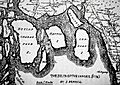
South Shahbajpur Island ( marked as DECCAN SHABAZPOUR l.) which is now Bhola in a 1778 map by James Rennell
-
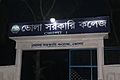
Bhola Government College main gate


See also
 In Spanish: Bhola (zila) para niños
