Patuakhali District facts for kids
Quick facts for kids
Patuakhali
পটুয়াখালী
|
|
|---|---|
| Patuakhali District | |
| Nickname(s):
সাগরকন্যা (Daughter of the Sea)
|
|

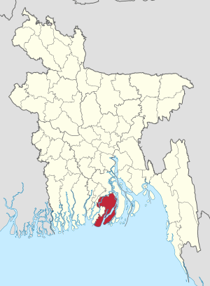
Location of Patuakhali in Bangladesh
|
|
| Country | |
| Division | Barisal Division |
| Patuakhali | 1969 |
| Area | |
| • Total | 3,220.15 km2 (1,243.31 sq mi) |
| Population
(2011 census)
|
|
| • Total | 1,535,854 |
| • Density | 476.9511/km2 (1,235.2976/sq mi) |
| Time zone | UTC+06:00 (BST) |
| Postal code |
8600
|
| HDI (2018) | 0.586 medium · 16th of 21 |
Patuakhali is a district located in the southwestern part of Bangladesh. It is part of the Barisal Division. People often call this district "SagorKonna," which means "Daughter of the Sea." This is because the Bay of Bengal is very close to it.
Contents
Exploring Patuakhali District
Patuakhali became a district in 1969. It covers an area of about 3,220 square kilometers. The district is home to over 1.5 million people, based on the 2011 census.
How Patuakhali is Divided
The Patuakhali District is split into smaller areas called Upazilas or Thanas. There are seven of these subdivisions:
- Bauphal Upazila
- Dasmina Upazila
- Dumki Upazila
- Galachipa Upazila
- Kalapara Upazila
- Mirzaganj Upazila
- Patuakhali Sadar Upazila
Patuakhali's Economy
The main way people in Patuakhali earn a living is through farming. Many people also work in fishing.
Farming in Patuakhali
Farmers in Patuakhali grow many important crops. The main crops are paddy (rice), jute, and various kinds of vegetables. These crops are very important for the local food supply.
Fishing Industry
Fishing is a big part of the economy here. Thousands of boats go out into the deep sea every day. They come back with huge amounts of fish, which are then sold. This helps support many families in the district.
See also
 In Spanish: Patuakhali (zila) para niños
 | Valerie Thomas |
 | Frederick McKinley Jones |
 | George Edward Alcorn Jr. |
 | Thomas Mensah |

