
Llanquihue Lake facts for kids
Quick facts for kids Llanquihue Lake |
|
|---|---|

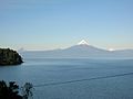
The lake as seen from Osorno volcano with Calbuco visible on the left
|
|

Llanquihue Lake
Location in Chile
|
|
| Coordinates | 41°08′S 72°47′W / 41.133°S 72.783°W |
| Primary outflows | Maullín River |
| Catchment area | 1,435 km2 (554 sq mi) |
| Basin countries | Chile |
| Surface area | 860 km2 (330 sq mi) |
| Average depth | 183.7 m (603 ft) |
| Max. depth | 317 m (1,040 ft) |
| Water volume | 158 km3 (38 cu mi) |
| Shore length1 | 197 km (122 mi) |
| Surface elevation | 70 m (230 ft) |
| Frozen | never |
| Settlements | Puerto Varas, Llanquihue, Frutillar, Puerto Octay |
| 1 Shore length is not a well-defined measure. | |
Llanquihue Lake is the second-largest lake in Chile. It covers an area of about 860 square kilometers (332 square miles). Only Lake General Carrera, which Chile shares with Argentina, is larger. Llanquihue Lake is located in the southern Los Lagos Region of Chile. It is found in the Llanquihue and Osorno areas.
The lake is famous for its amazing views of Volcán Osorno. This makes nearby cities like Puerto Varas very popular places for tourists to visit.
How Llanquihue Lake Was Formed
Llanquihue Lake has a unique fan-like shape. This shape was created by huge sheets of ice, called piedmont glaciers, during past Ice Ages. These Ice Ages are known as Quaternary glaciations.
The most recent Ice Age in this area is even named after the lake. It's called the Llanquihue glaciation. During this time, the moving glaciers left behind piles of rocks and dirt. These piles are called moraines, and they helped form the lake's edges.
Early Inhabitants of the Lake Area
Some historians believe that the ancient Chono people lived around Llanquihue Lake. The Chono people were nomads, meaning they moved from place to place. They likely traveled through this area a long time ago.
Gallery
-
A view of the Osorno volcano from across the lake

See also
 In Spanish: Lago Llanquihue para niños
