
General Carrera Lake facts for kids
Quick facts for kids General Carrera Lake |
|
|---|---|
| Buenos Aires Lake Lake Buenos Aires |
|
 |
|
|
General Carrera Lake in the Aysén Region
|
|

General Carrera Lake
Location in Chile
|
|
| Location | Lago Buenos Aires Department, Santa Cruz Province, Argentina / General Carrera Province, Aysén del General Carlos Ibáñez del Campo Region, Chile, in Patagonia |
| Coordinates | 46°26′15″S 71°42′54″W / 46.43750°S 71.71500°W |
| Type | Moraine dammed |
| Primary inflows | Soler, Los Antiguos, Jeinemeni, Ibáñez, San Martín, Delta |
| Primary outflows | Bertrand Lake and then Baker River (Pacific Ocean) Deseado River (Atlantic Ocean) |
| Catchment area | 14,861 km2 (5,738 sq mi) |
| Basin countries | Argentina, Chile |
| Surface area | 1,850 km2 (710 sq mi) |
| Average depth | 400 m (1,300 ft) |
| Max. depth | 586 m (1,923 ft) |
| Water volume | 740 km3 (180 cu mi) |
| Shore length1 | 707 km (439 mi) |
| Surface elevation | 217 m (712 ft) |
| Frozen | never |
| Settlements | Chile Chico, Puerto Ingeniero Ibáñez, Puerto Guadal, Los Antiguos |
| 1 Shore length is not a well-defined measure. | |
.png)
General Carrera Lake (in Chile) or Lake Buenos Aires (in Argentina) is a very deep lake. It is located in a region called Patagonia. This lake is shared by two countries: Argentina and Chile. Both names for the lake are accepted around the world.
The local people have their own name for the lake. In the Aonikenk language, it is called Chelenko. This name means "stormy waters," which tells you a bit about the lake's nature! Another old name for the lake was Coluguape, from the Mapuche people.
This lake was formed by glaciers long ago. It is surrounded by the tall Andes mountains. Water from the lake flows west into the Pacific Ocean through the Baker River. In the past, during the last ice age, the lake's water flowed east to the Atlantic Ocean through the Deseado River.
The weather around the lake is usually cold and wet. However, the lake itself has a special sunny microclimate. This means it often has better weather than the surrounding areas. Many small towns are located along the lake. These include Chile Chico and Puerto Ingeniero Ibáñez in Chile, and Los Antiguos in Argentina.
People first started living near the lake between 1900 and 1925. These were mostly local people and immigrants from Europe. In 1971 and 1991, eruptions from the Hudson Volcano caused problems for the local economy. This especially affected sheep farming. Today, a car ferry helps people travel across the lake. It goes between Puerto Ingeniero Ibáñez and Chile Chico. The lake is also a popular spot for fishing trout and salmon.
How Big is General Carrera Lake?
This lake covers a huge area of about 1,850 square kilometers (714 square miles). Most of it, about 970 square kilometers (375 square miles), is in Chile. The rest, about 880 square kilometers (340 square miles), is in Argentina. This makes it the largest lake in Chile. It is also the fourth largest lake in Argentina. The deepest part of the lake is about 586 meters (1,923 feet) deep.
What is the Geology of the Lake?
The lake sits in a large sunken area of land. This area formed because of movements deep within the Earth. These movements caused the land to drop down. This created a deep channel. Ancient glaciers then flowed through this channel. They helped shape the lake into what it looks like today.
One of the most amazing natural features of the lake are the Marble Caves. These are also known as the Marble Chapel and Marble Cathedral. They are unique rock formations found along the lake's shore. These are a group of caves, columns, and tunnels. They are made from solid marble. The lake's waves have slowly carved these beautiful shapes over thousands of years.
Gallery
-
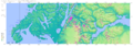
SRTM-Topography of the Chilean zone
-
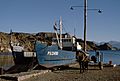
Boat near Chile Chico in Chile
-
Map of the Chilean zone


See also
 In Spanish: Lago Buenos Aires/General Carrera para niños
