
Venezuelan Andes facts for kids
Quick facts for kids Venezuelan Andes |
|
|---|---|
| Andes venezolanos | |
.jpg)
A view of Collado of Condor Peak in Venezuelan Andes
|
|
| Highest point | |
| Geography | |

Geographic map of the Andean Venezuelan natural region.
|
|
| Location | Táchira, Mérida and Trujillo states, the southern area of Lara, and portions of higher areas on the western side of Barinas, Apure, Portuguesa and Zulia states |
| Parent range | Andes |
| Geology | |
| Age of rock | Eocene |
| Type of rock | Igneous and metamorphic rocks |
The Venezuelan Andes (in Spanish: Andes Venezolanos) are a large mountain system in Venezuela. They are the northernmost part of the famous Andes mountain range. In Venezuela, people often just call them "the Andes."
These mountains are special because of how they were formed. Their rocks and shape clearly show they are part of the larger Andes. The Venezuelan Andes are like the end branches of the Eastern Mountain Range of Colombia.
In Venezuela, they split into two main parts:
- The Sierra de Perijá: This is a smaller range. It covers about 7,500 square kilometers in Venezuela.
- The Cordillera de Mérida: This is the larger part. It stretches over 40,000 square kilometers. This is what most people mean when they say "Venezuelan Andes."
The highest point in all of Venezuela is found in this mountain region. The Venezuelan Andes cover about 5.2% of Venezuela's land. This makes them the fourth largest natural region in the country.
Contents
Exploring the Venezuelan Andes
The Venezuelan Andes can be divided into two main areas. Each area has its own unique features.
Cordillera de Mérida
This part of the Andes covers most of the states of Táchira, Mérida, and Trujillo. It also reaches into southern Lara and parts of Barinas, Apure, and Portuguesa.
The Cordillera de Mérida can be split into three smaller sections:
- Western Venezuelan Andes: This includes areas like Macizo del Tamá and the high plains of Páramos Batallón y La Negra.
- Central Venezuelan Andes: Here you'll find the Macizo del Sur, Sierra Nevada de Mérida, Sierra de la Culata, and Sierra de Santo Domingo.
- North-Eastern Venezuelan Andes: This section includes the Sierra de Trujillo, Sierra de Portuguesa, and the Lara Andes.
Sierra de Perijá
This mountain range is located in the far west of Venezuela. It is in Zulia state and forms part of the border with Colombia.
How the Andes Were Formed
The Venezuelan Andes have a shared geological past. They started forming around 40 to 50 million years ago. This was during the Eocene period, which is part of the early Tertiary era.
At that time, three huge pieces of the Earth's crust, called tectonic plates, began to push against each other. These plates were the Nazca, Caribbean, and South American plates. Their collision caused the land to slowly rise, creating the mountains we see today.
Before these current Andes, there were "primitive Andes." These older mountains formed between the Cambrian and Silurian periods. However, by the Triassic period (in the Mesozoic era), they had almost completely worn away due to erosion.
Earth's Movements Today
Even today, the Earth's plates are still moving. This movement causes the ground to deform both up and down, and side to side. This creates faults, which are cracks in the Earth's crust. One important fault is the Boconó Fault Zone. It moves a few millimeters each year. You can see signs of this movement in the landscape, like long trenches or small ponds.
Ice Ages in the Mountains
Like many high tropical mountains, the Venezuelan Andes were covered by glaciers during the Ice Ages. This happened when the Earth was much colder.
Ancient Glaciers
Scientists have found signs of two main glacier periods in the Cordillera de Mérida. One set of glacier marks is found between 2,600 and 2,800 meters high. Another set is between 2,900 and 3,500 meters high. These show how far the ice reached. During the last major Ice Age, about 600 square kilometers of the Cordillera de Mérida were covered in ice.
In the Sierra de Perijá, there are also signs of glaciers between 2,700 and 3,100 meters high.
Recent Ice Periods
There is also evidence of a colder period more recently, between the 15th and mid-19th centuries. This time is known as the Little Ice Age. Glaciers grew again during this period. The marks from these glaciers are found around 4,700 meters high, just below where glaciers are found today.
Gallery
-
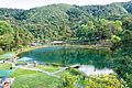
Los Cedros Lagoon, Trujillo State
-
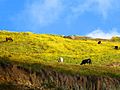
Fauna of the Venezuelan Andes
-
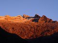
Humboldt Peak
-
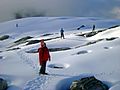
Snow in the Humboldt Peak
-
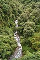
Butare River
.jpg)


See also
 In Spanish: Andes venezolanos para niños
