
Geoid facts for kids

The geoid is a special shape that describes the Earth's surface. Imagine if the entire Earth were covered by oceans, and there were no winds or tides. The surface of these oceans would form the geoid. It's like the true physical shape of our planet, shaped only by Earth's gravity and its rotation.
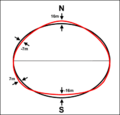
The geoid is not a perfect sphere. It's more like a slightly flattened ball, wider around the middle (the equator) and flatter at the poles. This shape is called an oblate spheroid. Many spinning objects in space, like planets and stars, have a similar flattened shape because of their rotation.
Contents
What is the Geoid?
The geoid is a 3-D (three-dimensional) shape that helps scientists understand the Earth's exact form. It's the surface where the pull of gravity is the same everywhere. Think of it as the "mean sea level" extended all over the Earth, even under the continents.
This important concept was first described by a famous mathematician named Carl Friedrich Gauss in 1828. It's a key idea in geodesy, which is the science of measuring and understanding the Earth's shape, size, and gravity field.
Why is the Earth Not a Perfect Sphere?
The Earth spins very fast, completing one rotation every 24 hours. This spinning motion causes the Earth to bulge out at the equator and flatten at the poles. It's similar to how a spinning ball of dough might flatten out.
Because of this bulge, the distance from the Earth's center to the equator is slightly greater than the distance from the center to the poles. This is why the Earth is described as an oblate spheroid, rather than a perfect sphere.
Geoid vs. Reference Ellipsoid
For many everyday uses and simpler calculations, scientists often use a simpler shape called a reference ellipsoid. This is a smooth, mathematical shape that is a good approximation of the Earth's overall form. It's much easier to work with in maps and navigation systems.
However, the geoid is more complex because it shows the small bumps and dips caused by variations in Earth's gravity. These variations happen because the Earth's mass (and therefore its gravity) isn't perfectly uniform. Some areas have more dense rock, pulling gravity stronger, while others have less. The geoid captures these tiny differences, making it the most accurate model of Earth's true physical surface.
Images for kids
-
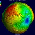
Geoid undulation in pseudocolor, shaded relief and vertical exaggeration (10000 scale factor).
-
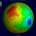
Geoid undulation in pseudocolor, to scale.
-
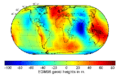
Map of the undulation of the geoid in meters (based on the EGM96 gravity model and the WGS84 reference ellipsoid).
-
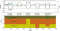
Gravity and Geoid anomalies caused by various crustal and lithospheric thickness changes relative to a reference configuration. All settings are under local isostatic compensation.
-

Three-dimensional visualization of gravity anomalies in units of Gal., using pseudo color and shaded relief.
-
Geoid undulation (red) relative to the reference ellipsoid (black), greatly exaggerated; see also: Earth's pear shape.


See also
 In Spanish: Geoide para niños
