
Carancahua Bay facts for kids
Quick facts for kids Carancahua Bay |
|
|---|---|

View of northern Carancahua Bay
|
|

Carancahua Bay
Location in Texas
|
|
| Location | Texas Gulf Coast |
| Coordinates | 28°41′28″N 96°24′08″W / 28.691039°N 96.402283°W |
| River sources | East Carancahua Creek, West Carancahua Creek |
| Ocean/sea sources | Gulf of Mexico |
| Basin countries | United States |
Carancahua Bay is a long, narrow body of water in Texas, United States. It stretches north from the larger Matagorda Bay. You can find it in Jackson and Matagorda counties. The bay is usually about 1 mile (1.6 km) wide, except near its wider mouth.
This bay is very important for nature. It acts as a special "nursery" for baby shrimp to grow. Many different kinds of birds and fish also live here. Because the areas near the shore can sometimes flood, and there are many mosquitoes, big towns haven't been built right on the bay. However, smaller communities like Port Alto and Carancahua are located along its western and eastern sides.
Contents
History of Carancahua Bay

The name Carancahua comes from the Karankawa Indians. This Native American group used to live along the bay's shores.
Early European Exploration
The first European known to visit the bay was Martín de Alarcón. He was a Spanish Royal Governor of Texas. In 1718, he explored Matagorda Bay with guides from the Tejas tribe. During his trip, he saw two Karankawa Indians near the bay. They were scared and quickly swam across the water.
The next day, the Karankawa people came ashore in a large canoe. They told the Tejas guide that they wanted Alarcón and his men to leave. As a sign of peace, Alarcón gave them tobacco and clothes. The Karankawa accepted these gifts. In return, they offered Alarcón dried fish. They also pointed him toward an old French fort, thinking he wanted to build a new settlement. Alarcón claimed the bay for Spain, but he didn't build a permanent town there.
Life on the Bay Shores
Only a few small communities have ever been built on Carancahua Bay. The town of Carancahua started in the 1880s. It was a small collection of cabins used as a mail stop between Texana and Matagorda. However, the bay often flooded, and there were many mosquitoes that carried diseases like malaria. This made it hard for the town to grow.
People living there often talked about the huge swarms of mosquitoes. One rancher from the late 1800s described them: "A strong easterly wind had been blowing for three days. On the third evening, the mosquitoes arrived. They flew high, about fifty feet, looking like a cloud of mist over Carancahua Bay. At the ranch, they attacked everything that had blood in it. All work stopped for nearly five days. After that, the main group passed, but plenty remained to make things uncomfortable for about two weeks."
Around 50 people lived in Carancahua in 1915. But the population dropped to 25 in the next ten years. Today, it's still a community, but we don't know exactly how many people live there.
Across the bay, another settlement called Persimmon Point was renamed Port Alto in 1939. This town grew, attracting people who were retired and those on vacation. In 1961, its summer population reached 205 people. However, Hurricane Carla destroyed the town in September 1961. It was rebuilt five years later. By 1970, a beach was built along the shore, and the population was 170. In 2000, 45 people lived in Port Alto.
Schicke Point, near the mouth of the bay, was once a small ranch and farm. It was named after Clarence Schicke, who came from Illinois to hunt and fish. After Hurricane Carla, he started commercial fishing and building cabins. Schicke Point is now popular with sports fishermen. It has about 90 residents, including famous anglers like Roy Cross and Otto Mendel. Cape Carancahua is a private community on the bay's northern shore.
Features of Carancahua Bay

Carancahua Bay has two smaller parts near its mouth with Matagorda Bay. These are Redfish Lake and Salt Lake. On the eastern side of the bay's mouth is Schicke Point. From there, the shore curves north to the Schicke Point Community, which has many private docks. Further north, you'll find the El Campo Club community with homes along the coast and docks reaching into the water.
The bay then turns sharply west, passing a swampy area. It becomes narrower as it goes north from Calhoun into Jackson County. The shoreline continues north, passing several oil wells, until it reaches the town of Carancahua. North of the town, a small inlet forms, surrounded by swamps. The bay then winds west to a large swamp. After the swamp, the bay gets even narrower and continues south along the Cape Carancahua community, which is almost surrounded by water.
Past the cape, the bay turns north and is crossed by Texas State Highway 35. It then heads west and north again, getting narrower until it reaches the marsh where Carancahua Creek flows in. The East and West Carancahua Creeks join together before they enter the bay. West Carancahua Creek flows 28 miles (45 km) south from White Hall. East Carancahua Creek flows 32 miles (51 km) southwest from Wharton County. Both creeks sometimes dry up in their upper parts.
The western shore of the bay looks similar to the east. South of the Carancahua Creek mouth is Weedhaven. Further south, the shore mirrors Cape Carancahua and heads northeast past oil wells to a sharp point. The shoreline continues directly south to a large swamp. After the swamp is the town of Port Alto, which has many docks and piers.
Ecosystem of Carancahua Bay

Carancahua Bay is a protected area in Texas. A group of 300 members, called the Carancahua Bay Protection Association, also helps protect it. As mentioned, it's a nursery for shrimp. It's also home to shellfish like oysters. Fishermen often catch finfish such as redfish and black drum here.
Many different birds live around the bay. These include the wood ibis, roseate spoonbill, snowy egret, great-tailed grackle, Louisiana heron, willet, black-necked stilt, crested caracara, and the black vulture.
In 2004, the Texas Commission on Environmental Quality checked Texas waterways. They found slightly higher than normal levels of bacteria at the mouth of Carancahua Creek. They also found high pH levels, which can happen when too many algae grow. These issues were common in the waterways they studied, and they planned to address them.
Industries Around the Bay
Because Carancahua Bay is a nursery for shrimp, regular shrimping is not allowed in its waters. However, shrimp farms have been built on land along its shores. Harvesting shellfish, especially oysters, is carefully controlled. It's only allowed at certain times and in specific places.
The main Matagorda Bay is approved for shellfish production. But Carancahua Bay has different rules. Some areas are restricted, and others are conditionally approved. The Texas Department of State Health Services describes the conditionally approved areas as being from the bay's mouth up to a "beige house" on the eastern shore and across to a "grey barn" on the western shore. A small part near Port Alto is restricted. All areas north of this line are also restricted.
You can also find several oil and natural gas wells along the shoreline and even in the waters of Carancahua Bay. One important area is the Appling Field segment, about a mile offshore from Port Alto. It's believed to contain a lot of natural gas. This field was first found in the 1950s but was later left alone. Now, companies are working to develop new gas reserves in the area.
Images for kids
-
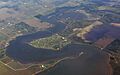
View of northern Carancahua Bay
-
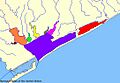
Carancahua Bay (yellow) is part of the larger Matagorda Bay system.
-
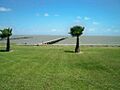
The bayfront of Carancahua Bay seen from Port Alto.
-
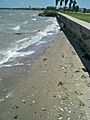
A beach made of sand and shells on the shore of Carancahua Bay.
