
Magnet, Texas facts for kids
Quick facts for kids
Magnet, Texas
|
|
|---|---|

Magnet, Texas
Location in Texas

Magnet, Texas
Location in the United States
|
|
| Country | United States |
| State | Texas |
| County | Wharton |
| Elevation | 72 ft (22 m) |
| Time zone | UTC-6 (Central (CST)) |
| • Summer (DST) | UTC-5 (CDT) |
| ZIP code |
77488
|
| Area code(s) | 979 |
Magnet is a small, rural community in southeastern Wharton County, Texas, United States. It's called an unincorporated community because it doesn't have its own local government like a city or town.
You can find Magnet where State Highway 60 meets County Road 102. It's not far from the border of Matagorda County. You'll know you're there by the road signs on Highway 60 and a very tall broadcasting tower. In 2000, about 42 people lived in Magnet. It's also part of the larger Greater Houston area.
Contents
History of Magnet
How Magnet Started
Around 1907, a company from Oklahoma called Taylor-Fowler Land Company started planning a town in this area. They built it along the Gulf, Colorado and Santa Fe Railway line. In 1911, two brothers, Frank D. and Fred Fowler, began selling a huge amount of land, about 12,000 acres. They told people the soil was very rich and good for farming.
A post office opened in Magnet the same year. There are two stories about how the town got its name. One story says it was called Magnet because the good soil would "attract" or draw in new farmers. Another story claims it was because the saloons (places to drink) in Magnet would attract people from nearby Bay City, which didn't allow alcohol.
Early Growth and Oil Discovery
By 1912, Magnet was growing! It had a few grocery stores, a drugstore, a mill for grinding grain, a hotel, and a lumberyard. Just two years later, about 40 people lived there. The community also had a blacksmith shop, a factory for canning food, a cotton gin, a garage, two general stores, and a group for rice farmers.
In 1925, something big happened nearby: the first oil well in Wharton County started producing oil. This was in the Boling Field, close to Iago. This discovery led to an oil drilling boom in the 1920s, and the Magnet Withers oil field was first used during this time.
Later Years and Changes
By the 1930s, Magnet had about 50 residents. Even when more oil was found nearby in 1937, the population didn't really grow. By 1943, the post office was the only business left in the community.
By 1949, only 20 people lived in Magnet, and the post office closed in 1954. From 1968 to 2000, the population stayed at 42 people. In 2000, there were no businesses reported in Magnet. In 2004, the BNSF Railway wanted to stop using a part of the railway line that went through Magnet because no trains had used it for two years. However, in 2012, an oil company successfully drilled three new wells in the Magnet Withers oil field.
Geography
Magnet is located on the east side of State Highway 60. It's about 11.8 miles (19.0 km) north of Bay City and 13.4 miles (21.6 km) southeast of Wharton.
Another road, Old Lane City Magnet Road, runs next to Highway 60 on the east side. It goes about 5.0 miles (8.0 km) northwest to Lane City. There are about two dozen homes grouped together in Magnet and along Mauldin Road, which goes northeast. The Magnet Baptist Church is also in the community, located on County Road 102. The area's oil field is named the Magnet Withers oil field after the community.
Education
Magnet had its own school by 1912. In 1926, the Magnet school had three teachers. They taught 130 white students and five black students. A map from 1936 shows that there were two schools in the area. In 1947, these schools became part of the Wharton Independent School District.
Images for kids
-
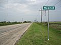
Magnet sign and broadcasting tower are on Highway 60.
-
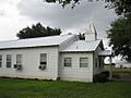
Magnet Baptist Church is on County Road 102.
-
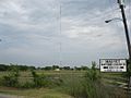
The broadcasting tower is a prominent landmark.


