Colorado County, Texas facts for kids
Quick facts for kids
Colorado County
|
|
|---|---|

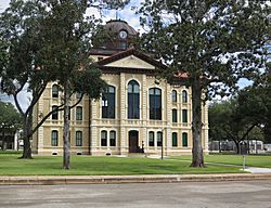
Colorado County Courthouse in Columbus. Built 1890-1891: this 2014 photo shows restoration to original color scheme made in 2013
|
|

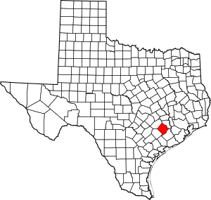
Location within the U.S. state of Texas
|
|
 Texas's location within the U.S. |
|
| Country | |
| State | |
| Founded | 1837 |
| Named for | Colorado River |
| Seat | Columbus |
| Largest city | Columbus |
| Area | |
| • Total | 974 sq mi (2,520 km2) |
| • Land | 960 sq mi (2,500 km2) |
| • Water | 13 sq mi (30 km2) 1.4% |
| Population
(2020)
|
|
| • Total | 20,557 |
| • Density | 21.106/sq mi (8.149/km2) |
| Time zone | UTC−6 (Central) |
| • Summer (DST) | UTC−5 (CDT) |
| Congressional district | 10th |
Colorado County is a county in the state of Texas. In 2020, about 20,557 people lived there. The main town and county seat is Columbus. The county gets its name from the Colorado River in Texas. It was started in 1836 and officially organized in 1837.
Contents
History of Colorado County
The land that is now Colorado County has been home to people for at least 12,000 years. Native American groups like the Coco branch of the Karaknawa and the Tonkawa lived or traveled through this area.

The first European to visit this area was René-Robert Cavelier, Sieur de La Salle on January 20, 1687. He camped near Skull Creek. Later, in 1689, Alonso De León might have also passed through while looking for a French fort.
Anglo settlers, who were part of Stephen F. Austin's "Old Three Hundred" group, began moving here in 1821. Some families settled near Beeson's Ford, which was close to where Columbus is today. This area was very active during the Texas Revolution. A person named Dilue Rose Harris wrote about her experiences during the "Runaway Scrape" while she was in Colorado County.
Colorado County was one of the first counties created when the Republic of Texas formed in 1836. After the American Civil War, many African Americans who had been freed from slavery lived here. A special office called the Freedmen's Bureau was set up in Columbus to help them.
Many European settlers, especially Germans, and people from what is now Czechoslovakia (like Moravians and Bohemians), moved to the county after the Civil War. Some Germans had already settled in the area as early as 1830.
Geography of Colorado County
Colorado County covers about 974 square miles. Most of this is land, with about 13 square miles covered by water.
Main Roads
 Interstate 10
 U.S. Highway 90
 U.S. Highway 90 Alternate
 State Highway 71
Neighboring Counties
- Austin County (to the northeast)
- Wharton County (to the southeast)
- Jackson County (to the south)
- Lavaca County (to the southwest)
- Fayette County (to the northwest)
Protected Areas
Population of Colorado County
| Historical population | |||
|---|---|---|---|
| Census | Pop. | %± | |
| 1850 | 2,257 | — | |
| 1860 | 7,885 | 249.4% | |
| 1870 | 8,326 | 5.6% | |
| 1880 | 16,673 | 100.3% | |
| 1890 | 19,512 | 17.0% | |
| 1900 | 22,203 | 13.8% | |
| 1910 | 18,897 | −14.9% | |
| 1920 | 19,013 | 0.6% | |
| 1930 | 19,129 | 0.6% | |
| 1940 | 17,812 | −6.9% | |
| 1950 | 17,576 | −1.3% | |
| 1960 | 18,463 | 5.0% | |
| 1970 | 17,638 | −4.5% | |
| 1980 | 18,823 | 6.7% | |
| 1990 | 18,383 | −2.3% | |
| 2000 | 20,390 | 10.9% | |
| 2010 | 20,874 | 2.4% | |
| 2020 | 20,557 | −1.5% | |
| U.S. Decennial Census 1850–2010 2010 2020 |
|||
In 2020, the population of Colorado County was 20,557 people. Most people identified as White (57.21%), followed by Hispanic or Latino (29.14%), and Black or African American (10.81%).
Towns and Communities
Cities
Census-Designated Places
These are areas that are like towns but are not officially incorporated as cities.
Other Communities
These are smaller, unincorporated places.
Ghost Towns
These are places that used to be communities but are now mostly abandoned.
- Lakeside
- Matthews
- New Bielau
- Osage
- Pisek
- Provident City
- Ramsey
See also
 In Spanish: Condado de Colorado para niños
 | Emma Amos |
 | Edward Mitchell Bannister |
 | Larry D. Alexander |
 | Ernie Barnes |

