
Sheridan, Texas facts for kids
Quick facts for kids
Sheridan, Texas
|
|
|---|---|

Sheridan, Texas
Location in Texas

Sheridan, Texas
Location in the United States
|
|
| Country | United States |
| State | Texas |
| County | Colorado |
| Time zone | UTC-6 (Central (CST)) |
| • Summer (DST) | UTC-5 (CDT) |
Sheridan is a small community in Colorado County, Texas, in the United States. It is known as an unincorporated community and a census designated place. This means it is a recognized area where people live, but it does not have its own city government like a big city would.
Contents
The Story of Sheridan
Sheridan got its start in 1908. A man named Hugh Sheridan sold a lot of land to a company called San Antonio Loan and Securities. This company then worked with a railway company to create and sell plots of land and small farms. This is how the town got its name!
Early Days and Farming
In September 1908, Sheridan got its own post office. The town was officially mapped out in 1909. To help people who wanted to buy land, a hotel was built in March 1909. Sheridan was advertised a lot in the Midwest, and the town grew quickly.
At first, the main crop grown here was figs. The Sheridan Fig Preserving Company shipped crates of figs by train all over the United States. Other popular crops included cucumbers, melons, potatoes, and strawberries.
Growth and Changes
The post office moved briefly in 1912 but came back to Sheridan a few months later. By 1914, about 150 people lived in Sheridan, and it had several businesses.
A big change happened in 1940 when the Shell Oil Company found natural gas in the area. This led to the creation of the Sheridan oil and gas field. Because of this, farming in the area became less common.
After World War II, train service stopped, but this did not hurt the town much. This was because U.S. Highway 90-A was improved, making it easier to travel by car. In 1986, Sheridan had 225 residents and seventeen businesses. It was known for raising cattle, its oil and gas field, and great deer hunting nearby. The population stayed at 225 through the year 2000.
Population Information
| Historical population | |||
|---|---|---|---|
| Census | Pop. | %± | |
| 2020 | 520 | — | |
| U.S. Decennial Census 1850–1900 1910 1920 1930 1940 1950 1960 1970 1980 1990 2000 2010 |
|||
Sheridan was first counted as a census designated place in the 2020 U.S. Census. This means it was officially recognized as a specific area for counting people.
2020 Census Details
The 2020 census showed that 520 people lived in Sheridan. The table below shows the different groups of people living there.
| Race / Ethnicity (NH = Non-Hispanic) | Pop 2020 | % 2020 |
|---|---|---|
| White alone (NH) | 342 | 65.77% |
| Black or African American alone (NH) | 7 | 1.35% |
| Native American or Alaska Native alone (NH) | 1 | 0.19% |
| Asian alone (NH) | 3 | 0.58% |
| Pacific Islander alone (NH) | 0 | 0.00% |
| Other race alone (NH) | 1 | 0.19% |
| Mixed race or Multiracial (NH) | 25 | 4.81% |
| Hispanic or Latino (any race) | 141 | 27.12% |
| Total | 520 | 100.00% |
Education
Students in Sheridan attend schools in the Rice Consolidated Independent School District. For higher education, the designated community college for this school district is Wharton County Junior College.
What Sheridan is Known For
Sheridan is known for several things. The most famous is probably the Splashway Waterpark and Campground. It is a large waterpark where families can enjoy slides and pools. It also has a campground for RVs and cabins.
The community is also known for its history with railway systems and for its cattle production.
Images for kids
-
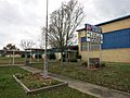
The Sheridan Elementary School is on FM 2437.
-
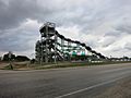
The Splashway Waterpark is on US 90A in Sheridan.
-
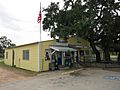
The US Post Office shares a building with a business.


