
Matthews, Texas facts for kids
Quick facts for kids
Matthews, Texas
|
|
|---|---|

Matthews, Texas
Location in Texas

Matthews, Texas
Location in the United States
|
|
| Country | United States |
| State | Texas |
| County | Colorado |
| Elevation | 167 ft (51 m) |
| Time zone | UTC-6 (Central (CST)) |
| • Summer (DST) | UTC-5 (CDT) |
| ZIP code |
77434
|
| Area code(s) | 979 |
| GNIS feature ID | 1380884 |
Matthews is a small, unincorporated community in Colorado County, Texas. It is located in the southeastern part of the county, south of the city of Eagle Lake. The community is found near where two roads, FM 102 and FM 950, meet.
Matthews was named after a man who owned a large farm (plantation) in the area before the American Civil War. By 2013, many things that were once part of Matthews, like its school, post office, businesses, and railroad, were gone. However, many silos in the area show that farming is still a very important activity there.
Contents
Where is Matthews?
Matthews is located in Texas, a state in the United States. You can find it in the southeastern part of Colorado County.
One way to find Matthews is near the intersection of FM 102 and Strickland Lane. Another spot is where Matthews Store Road crosses an old railroad path. The Texas State Historical Association also describes it as being where FM 102 and FM 950 meet.
Matthews is about 6.2 miles (10 km) south of Eagle Lake. It is also about 20.9 miles (34 km) northwest of Wharton if you travel on FM 102. If you take FM 950, it's about 6.4 miles (10 km) northeast of Garwood.
History of Matthews
Early Settlement and Plantations
The history of Matthews began in 1827. A man named John Matthews bought land from James Nelson. Nelson was one of the "Old Three Hundred" settlers who received land in Stephen F. Austin's early Texas colony.
John Matthews started a very successful farm, known as a plantation. By 1860, this plantation had 140 enslaved people working on it. The community that grew in this area served Matthews' plantation and other nearby farms. After the American Civil War ended, many of the formerly enslaved people chose to stay in the area.
Contributions of Freed Slaves
Many freed slaves and their families continued to live in and around Matthews. Some of them went on to achieve great things. For example, Rev. Daniel Whitley, who was enslaved on a nearby plantation, became a minister in both Columbus and Eagle Lake after he was freed.
His grandson, John Whitley, grew up in the area. He became a famous art restorer. He even restored all the paintings hanging in the Texas State Capitol.
Another important figure was Cicero Howard. He was Daniel Whitley's son-in-law. Cicero Howard was the second African American man to be elected to a county-level public office in Colorado County. He was also the first African American Colorado County Commissioner. This was a very important step for the community.
Growth and Decline of the Community
In 1880, the Matthews community had several businesses. These included a blacksmith shop, a cotton gin (a machine that separates cotton fibers from their seeds), and a general store.
The community got its own post office in 1895. Mary McRee was the first postmaster. In 1898, a railroad company called the Cane Belt Railroad was formed. By June 1899, this railroad line connected Eagle Lake to Wharton, passing through Matthews. The larger Atchison, Topeka and Santa Fe Railway bought the Cane Belt in 1904.
By 1900, Matthews had four businesses, a school, and about 100 residents. However, the post office closed in 1905, and mail started coming from Eagle Lake instead. The population stayed about the same until the 1960s. At that time, machines began to replace people for harvesting cotton. Farmers also started growing more rice and corn.
By the mid-1980s, only one local business remained in Matthews. The railroad line that ran through the area was closed in 1992, and the tracks were removed. You can still see where the old railroad used to be in satellite pictures, running next to FM 102.
Images for kids
-
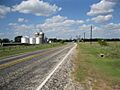
Silos along FM 950 as it approaches FM 102. Silos are used to store grain.
-
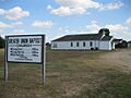
The Greater Union Baptist Church at FM 102 and Strickland Lane.
-

The sign marking the junction of FM 102 and FM 950 at Matthews.


