Mackay, Texas facts for kids
Quick facts for kids
Mackay, Texas
|
|
|---|---|

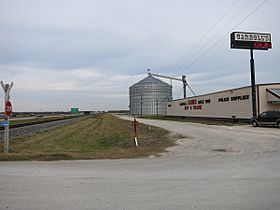
Silo and gun store on the east side of US 59
|
|
| Country | United States |
| State | Texas |
| County | Wharton |
| Elevation | 98 ft (30 m) |
| Time zone | UTC-6 (Central (CST)) |
| • Summer (DST) | UTC-5 (CDT) |
| ZIP code |
77488
|
| Area code(s) | 979 |
| GNIS feature ID | 1380124 |
Mackay is a small, unincorporated community in central Wharton County, Texas. An unincorporated community is a place where people live, but it doesn't have its own local government like a city. Mackay is located southwest of the city of Wharton along U.S. Route 59.
This community started as a stop for trains in 1881. Many new people moved there, especially after 1907. Mackay had its own post office for a while, from 1921 to 1937. By 1990, most of its original buildings were gone. Today, you might see a few businesses and a large grain silo in the area.
History of Mackay
Mackay began in 1881 as a station on the New York, Texas and Mexican Railroad. It was named after John William Mackay, a rich investor in the railroad. The train station was built on land owned by Abel Head "Shanghai" Pierce. His large ranch nearby was managed by his nephew, A. P. Borden.
A post office opened in Mackay for a few months in 1885, but then it closed. In 1907, the USDA started an experimental farm there. They grew tea and camphor plants. Workers from Russia and China came to work on this farm. A. P. Borden built homes for them near his company store.
In 1912, Borden built a school for the children of these immigrant workers. He later gave this school to the county. Borden also built a church in nearby Pierce because his wife wanted to teach Sunday School there. The post office reopened in Mackay in 1921, and Borden became the postmaster. By 1922, Borden stopped managing the Pierce Ranch. He started running his own large farm of about 5,000 acres (2,023 ha) from a big house in Mackay.
A. P. Borden passed away in 1934. His property was then sold to Johnny B. Ferguson, who was an oil wildcatter (someone who drills for oil in new places). Mail service stopped in Mackay in 1937. By 1940, only 20 people lived in the community.
Ferguson found oil on the ranch in 1949. He ran his oil company from Borden's old store. In 1953, Mackay's school became part of the Wharton Independent School District. Johnny B. Ferguson became well-known for owning famous racehorses like Top Deck and Go Man Go.
In 1967, the city of Wharton bought 89 acres (36 ha) from Ferguson to build an airport. Ferguson died in 1978. Two years later, the airport grew to 120 acres (49 ha). By 1990, most of the old buildings in Mackay had disappeared.
Where is Mackay?
Mackay is located on US 59. It is about 4.4 miles (7.1 km) southwest of Wharton. It sits at the intersection of US 59 and County Road 467. The entrance to Wharton Regional Airport is also on US 59, about 0.7 miles (1.1 km) southwest of Mackay.
In 2014, there were four main structures in the area. These included a gun store, a small house, a large grain silo, and a building that was both a gas station and a restaurant. Bosque Creek flows through the Mackay area. It then empties into the Colorado River south of Wharton.
 | Aurelia Browder |
 | Nannie Helen Burroughs |
 | Michelle Alexander |


