Nottawa, Texas facts for kids
Quick facts for kids
Nottawa, Texas
|
|
|---|---|

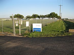
Tennessee Gas Pipeline Company compressor station on FM 1164
|
|
| Country | United States |
| State | Texas |
| County | Wharton |
| Elevation | 135 ft (41 m) |
| Time zone | UTC-6 (Central (CST)) |
| • Summer (DST) | UTC-5 (CDT) |
| ZIP code |
77435
|
| Area code(s) | 979 |
Nottawa is a ghost town located in Wharton County, Texas. A ghost town is a place that was once a community but is now mostly empty. Nottawa was situated in an area known for growing rice. It was found between the towns of East Bernard and Lissie. In 2016, a gas compressor station was still operating at the site.
Contents
The Story of Nottawa
Early Days and Cattle Ranches
The land where Nottawa was located had a railway line since 1859. This railway was called the Buffalo Bayou, Brazos and Colorado Railway. Back then, the land was mostly open space where cattle roamed freely.
Serious settlement in the area began in 1878. Many people from Czechia moved there to start new lives. Some English and Welsh settlers also came to the area. They were part of a project called New Philadelphia, which later became the town of Lissie.
New Farmers and Rice Production
After the first group of settlers, a new wave of people arrived. A promoter named John Linderholm bought a huge amount of land, about 60,000 acres. He encouraged farmers from the Midwest to move to Texas.
However, these farmers were disappointed. The crops they usually grew did not do well in the Texas soil. Luckily, in 1898, something important was discovered: the area was perfect for growing rice! This discovery saved the farming community. Soon, Wharton County became a major producer of rice.
Growth and Decline of the Community
Nottawa was founded in the late 1880s. It started with just one general store. In 1904, Nottawa got its own post office, and Frank C. Boyden became the first postmaster.
By 1914, the small community had a blacksmith shop and a general store called Darby and Reed. A few years later, in 1917, the Nottawa Common School No. 37 opened. It taught children from first to sixth grade.
Even though the 1920 census reported only 25 people living in Nottawa, more people were registered to vote. This shows that the community was a bit larger than the census count suggested.
Changes and Disappearance
Over time, things began to change for Nottawa. In 1930, the post office closed down. In 1945, the Nottawa school joined with the schools in East Bernard.
As roads improved, people found it easier to travel to East Bernard for shopping and church. This meant that the local store in Nottawa closed in the late 1940s.
In 1944, the Tennessee Gas Pipeline Company opened a booster plant nearby. They built homes and a community center for their employees. However, most of these homes were moved or sold in the 1970s.
In the late 1970s, a company called Occidental Petroleum started a research farm in the area. They tested new types of rice and soybeans for farmers in Asia. This research center closed in 1991. After that, the community of Nottawa officially ceased to exist, becoming a ghost town.
Where Nottawa Was Located
Nottawa was situated where U.S. Route 90 Alternate (US 90A) and Farm to Market Road 1164 (FM 1164) meet. East Bernard is about 4.8 kilometers (3 miles) to the east. Lissie is the same distance to the west.
US 90A runs south of and parallel to the Union Pacific Railroad tracks. There are still a few homes on County Road 270, which runs next to the railroad on its north side. The area is mostly covered by rice fields. Two creeks, Middle Bernard Creek and West Bernard Creek, are on either side of the former community.
 | John T. Biggers |
 | Thomas Blackshear |
 | Mark Bradford |
 | Beverly Buchanan |


